Listing Left
Suddenly, starting on March 4, 2010, there were a lot of reports indicating that the Earth was leaning
slightly to the left, leaning her N Pole away from Planet X approaching from the right. To avoid
confusion, let me explain that this perspective is as viewed from someone in the northern hemisphere
looking toward the Sun during the day. On the dark side of the Earth at this time, the lean would seem to
be to the right. But this process is referred to as a lean to the left for simplicity. The reports came in
from all over the world, and from many different message boards such as the Pole Shift ning and
GodlikeProduction. All these reports indicate a slight lean of the globe to the left.
- Saskatchewan, Canada
March 4, 2010
- Yes, During the summer we noticed instead of the sun being in the usual SW position it
seemed to steadily be in the NW position. I noticed it the other day with a clear sky. My
backyard fence faced directlly west, with a tree in the SW position and my garden gate in
the NW position. One day it seems the sun is in the correct SW position and the next
moment it's in the NW position. Hard to miss when observed. Noticing the sun should be in
a position at a particular time, but seems to have shifted more to the NW than ever at this
time. I've noticed it for many months.
-
- San Diego
March 4, 2010
- The Sun was way off today here in San Diego. I was shocked. Usually I see the sun set as I
get out of work around 5:30 pm PST. Yesterday I couldn't see anything because it was
setting to far south. The buildings were covering my view which has never the case! It has
always been due west! Now it is more south than I have ever seen it!
-
- San Diego
March 8, 2010
- The sun was out of place once again here in San Diego this morning. The sun is usually to
the right of one of the buildings that I work near. Today the sun was more to the left and
was directly behind the building.
-
- Los Angeles
March 4, 2010
- I always use Orion as center. In LA tonight it shifted horizontally to right of center from
last night. Way out of position from last night. Usually stars rise in east set in west, tonight
they seem to be going from south to north.
-
- South Carolina
March 4, 2010
- Today, I was struck with the very very obvious mislocation of the sun on my way home
from work. It was way too far to the NW for this time of year and it happened in only a
day's time. Yesterday it was in the standard SW position. I drive a 7 mile rural road to and
from work every day that has no curves and 2 medium to small size hills. Straight as an
arrow. On a clear winter day you can see the stop sign or tail lights at the top of the last
hill from the top of the first hill 6 miles away. Two times a year for a few weeks each, this
road will be torture to drive because the sun shines directly into your eyes going to work in
the morning, and coming home at night is the same way. The last few weeks, the sun has
bounced from one side of the road to the other. Consider the road to be pointing to 12:00
o'clock. Today the Sun was at the 1:30 position where yesterday it was at the 11:00
position.
-
- Ohio
March 6, 2010
- My patio has always been in the shade; a very cool spot in summer. The house is oriented
directly S (front) to N (rear of house). Patio is on North side of house. The Sun has moved
to the NW, thus allowing more sunlight to stream across the patio that used to be totally in
the shade, all year long. Sun used to set due West exposing just the Northern edge of the
patio to sunlight. I started noticing, especially this week when I let puppy out, my patio is
filled with sunlight. Seemed something not quite right. You know the feeling you are
looking at something, but not quite believing what you are seeing. Now, today, here is 4:48
pm EST, bright sunshine, like a summer day, and a pie slice of around 40° on the patio is in
sunlight.
It was not just the position of the Sun, the constellations also were dramatically out of place. Note for
the first report, if in cental Wisconsin, Polaris should be at Azimuth 359° and Altitude 43° while
Alderamin should be at Azimuth 344° and Altitude 19°. This is off by 16° for Azimuth combined 24° for
Altitude, too high in the dome with a severe offside to the right (which is a lean to the left on the dark
side of the Earth).
- March 6, 2010
- I use a telescope with a clock drive and a nearly perfect alignment. Polaris always falls in
the center of my finder's cross hairs. Since the last few weeks it is no longer the case. It is
as Alderamin has become closer to my cross hairs . Take a look yourselves tonight.
-
- March 7, 2010
- Seriously, I noticed Polaris seems out of alignment just last night! My son and I had out his
telescope. I thought I was imagining things.
And there were the reports about GPS suddenly malfunctioning. Seriously malfunctioning. This
malfunction was first noticed on February 25, 2010 a couple days ahead of the Chile quake.
- Pennsylvania
February 26, 2010
- I use a GPS device in my car in northeastern Pennsylvania, and I've done so for about 24
hours every weekend since October of last year. On Thursday night (Feb. 25) when we
received about 14 inches of snow, the Garman brand GPS worked flawlessly as usual.
However, on the following night (Feb 26), when we received just a dusting of snow, the
GPS was going nuts all night. It stopped working about two or three times per hour, and
when it was working it often showed me driving on the wrong street. Sometimes the street
locations just floated up and down on the screen, as if the satellites were being buffed
around in their orbits. I first noticed the GPS acting up around 5:30 pm eastern time on
Friday afternoon (Feb 26), getting knocked out of commission 6 or more times per hour.
The voice on the GPS would say "Satellite signal lost," or something to that effect. The
screen would say "weak satellite signal". Usually the GPS is accurate to within half of a
city block, or even better. It even tells me what alley or court I'm in when I'm between
blocks. When the screen did work last Friday (Feb 26) night, sometimes the streets would
float up and down the screen, and they would be several blocks away. The GPS has never
done that before, and I've used it almost 24 hours a week or more since October.
Sometimes the street grid would rotate inexplicably on the screen.
Then February 27, 2010 at the time of the quake, this GPS unit was again malfunctioning. Could a lurch
to the left have caused the Chile quake which occurred at 1:34 am on Saturday, February 27, 2010?
If I'm correct the quake occurred at 1:34 am eastern standard time, or 6:34 UTC
on Saturday morning. At 1:30 am I picked up a young man in the Pennsylvania
city of Scranton and drove him for 30 minutes south to the city of Wilkes-Barre.
He took it upon himself to program the GPS for his street, and I told him it would
probably lose the signal before we arrived. Interestingly, the signal held for the
entire ride, but then it started acting up again around 2:15 am or so, about 45
minutes after the quake. On Saturday night into early Sunday morning the GPS
worked perfectly again for 11 hours straight. My GPS has never acted up like this
in the past. It's a Garmin brand, and the clerk at Best Buy told me it's the best
brand to get because Garmin has the most satellites in the sky.
And other reports after the quake, showing that GPS was still malfunctioning.
- Los Angeles
February 27, 2010
- I was driving down the coast of California on Saturday afternoon [Feb 27] into the late
evening. I know the route well but I turn on my GPS just for the company. Just outside of
LA I stopped for gas and then continued on southbound I-5. The GPS was telling me to
"turn around when possible" and head in the opposite direction (north) to go to San Diego
from LA. It was several miles before it reoriented itself and started giving the right
directions.
-
- Los Angeles
March 4,2010
- GPS is about 1.75 miles off, notice when I get off highway GPS says I'm on a different
street then I'm actually on. 1.75 mile down range.
-
- Columbus, OH.
March 4, 2010
- Yesterday my granddaughter was in Columbus, Ohio taking her State Boards. She had
started her examinations at 8 o'clock in the morning. By 3:15 pm, EST, new license in
hand, she headed home. Being unfamiliar with the layout of the city, she was heavily
dependent upon her GPS system. She turned it on, but kept getting a message that the
signal was lost. This was the only problem she had had all day. Funny thing was, it was a
beautiful, clear, sunny day in Columbus. The weather was like Spring.
This confusing picture was presented to the Zetas, who confirmed that a slight lean to the left was in
place.
ZetaTalk Explanation 3/6/2010: Nancy has been documenting what she assumes to be either an
increased wobble or a slight lean to the left. It is both, but it is the slight lean to the left that has
garnered attention as this has skewed the constellations out of place significantly and placed the
Sun very noticeably out of position. This is due to the increased pressure on the Earth's
magnetosphere from the hose of magnetons from the N Pole of Planet X. Planet X is coming
from the right, so the N Pole or Earth is leaning to the left. This is not, however, the lean to the
left we have predicted, which is preceded by a severe wobble. This is also not the severe wobble,
which will occur along with the lean to the left and 3 days of darkness during the last weeks. This
slight lean to the left is a temporary adjustment, which may result in a sudden bounce back with
an overcompensation of a lean to the right. These types of temporary adjustments will occur on
occasion as the Earth pulls hard to the left, to evade Planet X. All this pushing and wobbling and
bouncing lurches the Earth plates, and thus they move, causing earthquakes. Where this may
come and go, the pace will only increase, and certainly not go away.
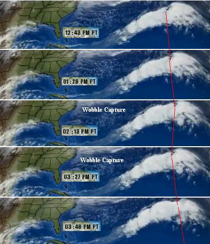
Satellite Evidence
The wobble is certainly also still with us, as this capture on IntelliWeather from the GOES-8 satellite for
March 5, 2010 shows. The video shows it best. Bear in mind that the map of the US is superimposed
beneath the cloud cover, as the satellite only clearly shows the clouds. Note how the clouds jump back
and then return to position, indicating the Earth wobbled under the satellite.
VIDEO: http://www.youtube.com/v/m9P8FW2dfpg
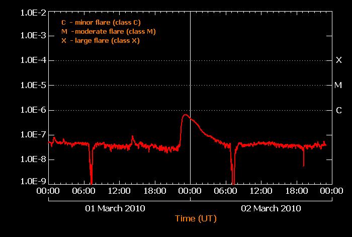
Another satellite, GOES-O, was displaying an odd daily dip in the x-rays received from the Sun, along
with a swell some hours later. Like clockwork, same time every day!
- http://www.nasa.gov/mission_pages/GOES-O/main/index.html
- GOES-O is the latest weather satellite developed by NASA to aid the nation's
meteorologists and climate scientists. The acronym stands for Geostationary Operational
Environmental Satellite. The spacecraft in the series provide the familiar weather pictures
seen on United States television newscasts every day. The satellites are equipped with a
formidable array of sensors and instruments
The dips were explained as a consequence of the satellite being eclipsed by the Earth, predicted to
happen during this period.
- http://www.swpc.noaa.gov/today.html
- Spring GOES-14 XRS Eclipse Season Feb 27 - Apr 14. During the spring and fall,
GOES-14 experiences eclipses in which the Earth blocks the X-ray instrument view to the
sun for short periods once each day. For spring 2010 this period will run from Feb. 27 to
Apr. 12, 2010. Eclipses ranging from minutes to just over an hour occur around 0700 UT.
At these times there will be a dip or gap in the XRS signal shown.
But the swell had no such explanation. And not related to solar flares at all. At most there was a minor
C2.2, no M or X class flares. The GOES system is geostationary, meaning a given satellite hugs the
Earth, is fixed over a certain location.
- http://en.wikipedia.org/wiki/Geostationary_Operational_Environmental_Satellite
- The Geostationary Operational Environmental Satellite (or GOES) system, supports
weather forecasting, severe storm tracking, and meteorology research.
What would cause the satellite to be flooded in x-rays, daily, at the same time? The Zetas, as always,
had an explanation. They have said, since the end of 2003 when the Earth was halted in its orbit around
the Sun, that the Earth was caught "in the cup" in front of the particle flows coming round from behind
Planet X. Well, here's proof!
ZetaTalk Explanation 3/13/2010: If this particular GOES satellite is in geostationary orbit such
that it experiences an eclipse by Earth at 7:00 UTC, then this point in time is when Greenwich is
experiencing a dawn. So the satellite in question is in the dark, over the Pacific or hours behind
Greenwich in time zones. Likewise when there seems to be a spike in x-rays around 0:00 UTC,
Greenwich is at midnight, behind the Earth on the dark side of the Earth. So the satellite hours
behind Greenwich presumably is at the dusk point. If there is a drop in X-ray receipt when
GOES-O is in eclipse behind the Earth, why would there be a spike when the satellite is at dusk?
The answer to this is in the particle flows roiling around the sides of Planet X.
Planet X is slightly to the right of the Sun in the line of view from the northern hemisphere. The
Earth is attempting to escape from the hosing of magnetic particles coming from the N Pole of
Planet X by pulling to the left, leaning its N Pole away to some extent. Thus, in the pincers that
hold the Earth in the eddy flow of particle flows, in the cup as we say, it is closer to the left hand
pincer than the right hand pincer. At dusk, the geostationary satellite is pushed into this stronger
flow, experiencing a spike.
Oarfish Omen
Giant oarfish, a deep water fish, have been appearing on the surface in such diverse places as England,
San Diego, and Japan. Known as the "Messenger from the Sea God's Palace", this is taken as an omen
of pending earthquakes.

- Oarfish Omen Spells Earthquake Disaster for Japan
March 4, 2010
http://www.telegraph.co.uk/news/worldnews/asia/japan/
- According to traditional Japanese lore, the fish rise to the surface and beach themselves to
warn of an impending earthquake - and there are scientific theories that bottom-dwelling
fish may very well be susceptible to movements in seismic fault lines and act in
uncharacteristic ways in advance of an earthquake - but experts here are placing more
faith in their constant high-tech monitoring of the tectonic plates beneath the surface.
-
- Mysterious Deep-Sea Fish Appears in Large Numbers
March 3, 2010
http://www.perkle.com/tag/giant-oarfish/
- Numerous specimens of large deep-sea fish about whose ecology little is known have been
found this winter in coastal areas along the Sea of Japan, such as Toyama and Ishikawa
prefectures, a rare phenomenon that has taken local residents by surprise. The fish, ryugu
no tsukai, or giant oarfish, is more than five meters long and is usually found at depths of
between 200 meters to 1,000 meters.
-
- Two More Giant Oar Fish Washed Up
February 25, 2010
http://www.onlinefishing.tv/news/two-more-giant-oar-fish-washed-up/
- Experts have been left flumoxed after two more deep water oarfish, also known as ribbon
fish, were washed up along the north east coast of England. The warm water species
should simply not be there!
-
- Navy Seal Training Camp off San Diego Captures Giant Oarfish
March 1, 2010
http://www.thejump.net/id/oarfish.htm
- The appearance of the fish follows Saturday's destructive 8.8 magnitude earthquake in
Chile and the January 12 tremors in Haiti. Concerns have been stoked by the unexplained
appearance of a fish that is known traditionally as the Messenger from the Sea God's
Palace. The giant oarfish can grow up to five metres in length and is usually to be found at
depths of 1,000 metres and very rarely above 200 metres from the surface. According to
traditional Japanese lore, the fish rise to the surface and beach themselves to warn of an
impending earthquake.
The Zetas concur.
ZetaTalk Comment 3/6/2010: These deep ocean fish as all surface or land based animals are
sensitive to stress the rock beneath them is enduring. Just as land animals flee the
electromagnetic screeches that rock under pressure release, sea life likewise attempt to flee. For
deep ocean fish, there is less of this screeching on the surface, because it is further away from the
rock.
New Video Clips
 The Zeta Report 38 - Earth changes predictions, what will sink and what will rise. The Zeta Report 38 - Earth changes predictions, what will sink and what will rise.
Added December 18. On YouTube.
 The Zeta Report 39 - Future Maps. Why the differences between the Toye, Scallion,
Pitre, Cannon, Snow, and Zeta maps? The Zeta Report 39 - Future Maps. Why the differences between the Toye, Scallion,
Pitre, Cannon, Snow, and Zeta maps?
Added December 18. On YouTube.
You received this Newsletter because you Subscribed to the ZetaTalk Newsletter service. If undesired, you can quickly
Unsubscribe.
|