Evidence of Wobble
Proof of the Earth wobble, a figure 8 formed daily around the Earth's magnetic N Pole, is never more
evident than when captured in global temperature maps. In Issue 112 of this newsletter, on December 28,
2008, a map showing snow-cover changes showed the wobble. This chart compared the year 2008 to the
composite for 1996-2005. The Earth wobble was dramatic, showing less snow cover in the US west and
above the Black Sea, on opposite sides of the globe from each other, and more snow cover below the
Great Lakes in the US and Mongolia, again on opposite sides of the globe from each other.
SOURCE: http://moe.met.fsu.edu/snow
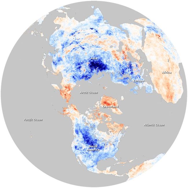
Now this pattern has been repeated in a global map showing temperature changes in the Northern
Hemisphere for the year 2009 when compared against a composite from the years 2000-2008. Here the
bands of warm and cold have shifted position slightly, but the pattern of two warm and two cool sites on
opposite sides of the globe from each other continued. The warmer spots are eastern Russia including
Kamchatka and Alaska - the entire region around and through the Bearing Straits - and northern Africa up
through the region of the Black Sea in eastern Europe. The cooler spots are the central US and Siberia
down through Mongolia.
- http://oko-planet.su/pogoda/pogodadiscussions/33742-xolodnaya-zima-2009-2010.html
- The average temperature last month of 2009 (December) compared with the average
December temperature for the period between the years 2000-2008. The blue color indicates
a lower temperature, red - higher. (Source photo: NASA) Meteorologists around the world
recorded record low temperatures: Nebraska (USA) -15 ° C; Beijing (China) -16 ° C; Florida
(USA) -15 ° C; Altnaharra (Scotland) -15 ° C; Amsterdam (Netherlands) -- 6 ° C; Hamburg
(Germany) -22,8 ° C; in some localities in Siberia thermometer dropped to -37 ° C.
Per the Zetas, the wobble has, if anything, increased in force.
ZetaTalk Explanation 11/14/2009: The magnetic N Pole of Earth is pushed away, forcefully, and
then allowed to bounce back into position later, forcefully. The Earth meanwhile is trying to
maintain its normal position, align with the Sun's magnetic posture. It is the force of the push that
is steadily changing.
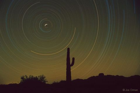
A Polaris wobble has also been documented via long-exposure photographs that show the movement of
background stars. This was covered in Issue 149 of this newsletter on September 6, 2009, showing that a
2007 long-exposure photo has a horizontal skew.
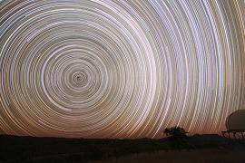
This issue, of long-exposure photos of Polaris showing a skew, came up again recently on the Pole Shift
ning. A photo taken on March 23, 2010 shows a decided oval shape, a horizontal skew, when compared
to what a normal long-exposure photo of the North Star is supposed to show. The skew has gotten
worse.
South Atlantic Cyclone
Up until the years following the arrival of Planet X into the inner solar system in 2003, certain parts of the
world were exempt from hurricane or cyclone activity. This included the South Atlantic along the coast of
South America. In the Pacific such storms are called cyclones, but in the Atlantic are typically called
hurricanes. These terms are both describing the same type of storm. The first ever hurricane/cyclone to hit
the east coast of South America occurred on March 28, 2004 off-shore from the southern Brazilian state
of Santa Catarina. A second such hurricane/cyclone has now occurred.
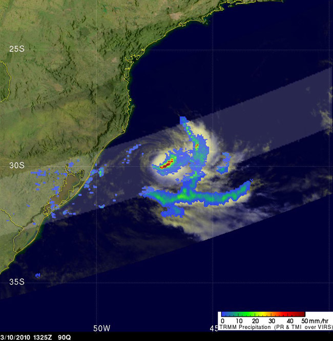
- Second Tropical Cyclone Ever Forms in South Atlantic
March 11,2010
http://www.livescience.com/environment/second-south-atlantic-cyclone-100311.html
-
The second ever tropical cyclone to form in the South Atlantic has been spotted about
180 miles off the coast of Brazil. Tropical cyclones typically don't form in the Southern
Atlantic because the waters are usually too cool. However, forecasters at the Naval
Research Laboratory noted that a low pressure system off the coast of Brazil appeared
to have tropical storm-force winds. The storm has been dubbed Tropical Storm 90Q.
The first known South Atlantic tropical cyclone (the collective name for tropical
storms, hurricanes and typhoons) was seen in 2004 and called "Catarina." A hurricane
called "Catarina" made landfall on March 28, 2004 near the town of Torres in the
southern Brazilian state of Santa Catarina (thus, the storm's name). It was the first
"hurricane" ever observed by satellite in the south Atlantic." While tropical cyclones in
the Northern Hemisphere spin counterclockwise, those in the Southern Hemisphere
spin clockwise.
Anticipating the Earth wobble, the Zetas predicted that hurricanes would occur in atypical places,
hinting at the South Atlantic.
ZetaTalk Prediction 9/15/1999: Hurricanes will be no more fierce than they are today, but
will occur in places not used to hurricanes force winds. Not just Japan and the East Coast of
the US and Bangladesh, but other places, perhaps the west coast of Africa, places that do not
expect hurricanes blasting inland.
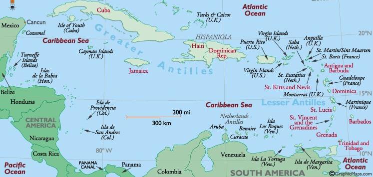
Caribbean Crunch
In anticipation that the S American Plate will roll, putting pressure on the Caribbean Plate and causing
some islands there to submerge, the Zetas were besieged with question on the live ZetaTalk chat. As noted
in the last newsletter, Issue 178, the spine of the Andes is experiencing numerous earthquakes and the
Caribbean is very restless. Such a strong combination of Earth changes is anticipated to move the
countdown to a 7 of 10, as noted in the last newsletter.
Question: There's been a suggestion that the Caribbean and Central America are
about to suffer a catastrophic tectonic disaster. Is this true?
ZetaTalk Response 3/27/2010: The holographic presentation that Nancy attended last November
included a rolling of the S American Plate with mountain building in the Andes and crushing of a
part of the Caribbean Plate during this roll. We are not allowed to state when such a process might
start, though there is much speculation because of the Chile quake and subsequent quakes that are
running up and down the Andes, and restlessness in the Caribbean. Beyond the fact that we have
confirmed this holographic presentation to be valid, in the steps it relayed, and beyond stating that
to move to a 7 of 10 one or more of these described catastrophe's must happen, we can say no
more.
Question: If the Caribbean 'event' were to occur, would you expect Trinidad to be
destroyed? Given the geography of the southern edge of the Caribbean plate, it
looks as though it might be ripped in two.
ZetaTalk Response 3/27/2010: For those wondering what islands will be at risk during any S
America plate roll, we suggest the following exercise. Establish the fault lines, the borders of the
two plates in question - S America Plate and Caribbean Plate. Pin the S America Plate at the tip,
but spread the Atlantic apart so the top part of S America must roll to the west. Clearly, this puts S
America pushing over the Nazca Plate to her west, which is occurring now and causing quakes all
up and down the Andes. For the Caribbean Plate, which includes Pamana and Central American
countries, there is pressure where the Caribbean Plate loses when encountering the larger and
more solid S American Plate. The damage to the Caribbean Plate is not just to those areas which
will be pushed under the gliding edge of the S American Plate, but also to those areas which will be
dragged along, and ground up as the plate border is rubbed like sandpaper, an abrasion. In
addition, the Caribbean Plate will react to pressure on one side by raising an edge on the opposite
side. And any associated fault line will likewise react. This is a complicated matter, but suffice it to
say that there will be no islands in the Caribbean which will not be affected, nor will the countries
in Central America find themselves exempt.
A number of people on the Pole Shift ning promptly set out to examine the Caribbean Plate, which proved
to be complicated indeed. In the first place, it is not clear just what land rides on just what plate. Panama in
some maps is considered part of the Caribbean Plate, and in others to be riding on its own plate, the
Panama Plate. Likewise, a portion of the S American Plate encompassing portions of Ecuador, Colombia,
and Venezuela is considered by most to be part of the S American Plate, but by other maps to be on what
is called the North Andes Plate.
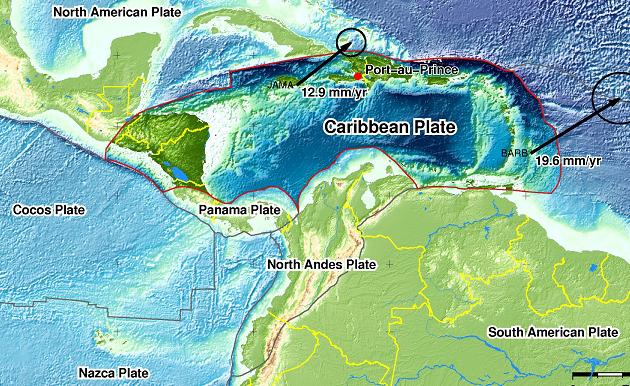
Notice in this map of the region how deep the waters of the Caribbean are. This is because the Caribbean
Plate has been sinking, over time. Here's a diagram of the presumed land masses some 10 million years
ago. A land bridge existed from the Florida region over to Venezuela, and the Caribbean offshore from
Honduras and Nicaragua was likewise land.
SOURCE: http://www.fiu.edu/orgs/caribgeol/Caribtect/Carib010.gif
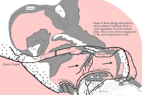
Looking at this complicated picture, just what portions of the Caribbean Plate will be pushed under as the
S American Plate rolls? It certainly appears that the hump just north of Colombia, what some consider the
North Andes Plate, would push over that portion of the Caribbean Plate just to the west of this hump.
After all, the portion of the Caribbean Plate just to the west of this hump is deep water, so it has clearly
been pushed down in the past. Presumably, also, the Caribbean Plate would hold together and move as
one. If the southern portion of the Caribbean Plate were pushed down by this action, then Trinidad,
Grenada, Barbados and the islands up toward Barbuda would likewise potentially be pushed down, with
islands offshore from Central America likewise vulnerable.
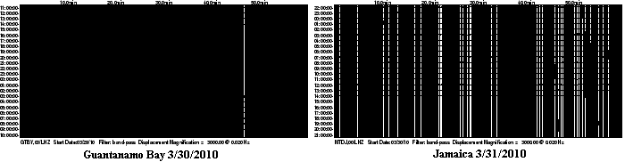
It was noted on last weeks newsletter, Issue 178 that a number of islands on the southern part of the
Caribbean Plate were jiggling, the live seismograph for this or that island turning black on occasion. This
past week the northern part of the Caribbean Plate is also starting to jiggle, Guantanamo Bay turning black
on March 30 and Jamaica on March 31. The Caribbean plate is vibrating!
You received this Newsletter because you Subscribed to the ZetaTalk Newsletter service. If undesired, you can quickly
Unsubscribe. You can always access prior Newsletters from the Archives.
|