Coral Sea Rising
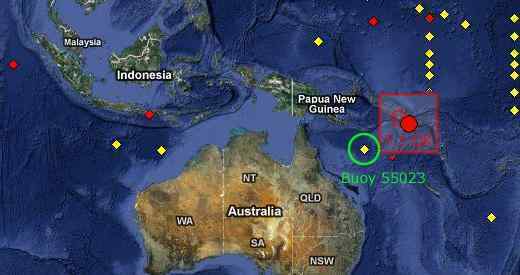
Coral Sea tsunami buoy 55023 was featured in Issue 182 last April, 2010 as it had indicated the sea bed there was rising.
This has become more extreme. The buoy indicated a sudden 400 foot drop in water depth, from 4600 to 4200 feet, and
irregular tides thereafter.
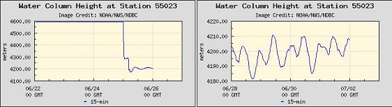
Within a day there was a 7.1 quake recorded in the Solomon Islands nearby, just along the Indo-Australian Plate border.
Origin Time: 26 Jun 2010 05:30 UTC 26 Jun 2010 05:30 UTC
Magnitude: 7.1 Mwp
Is there a relationship between the change in water depth and this quake? Per the Zetas, there is indeed.
ZetaTalk Explanation 7/3/2010: When asked about this in April, 2010 when buoy 55023 first began showing the sea
floor rise, we mentioned not only the steadily rise of the eastern edge of the Indo-Australian Plate but flexible parts
of this plate while can flex when the plate position changes. Plates are heavy, and when they are tipped up, they
can bend at the point where they are becoming suspended, bend under the weight of rock no longer supported by
magma. A void is created under that part of the plate, in essence. The sudden precipitous drop in water height on
June 25 does indeed have a relationship to the 7.1 quake in the Solomons a day later. This activity, the lift in the
plate, has gotten stronger, and the trend will only increase in the near future.
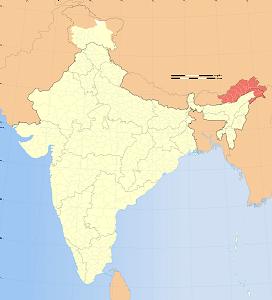
India's Grim Fate
India is fated to be a country complete pushed under the waves during the coming pole shift, because the Indo-Australian
Plate is plunging under the Himalayas. This final devastating plunge will occur during the hour of the pole shift, per the Zetas,
though hints of this sinking have appeared. Islands are disappearing in Bangladesh. And the pressure from subduction in
upland Arunachal has created a new point where lava is flowing.
- New Moore Island Disappears - Global Warming Responsible
March 24, 2010
http://news.gather.com/viewArticle.action?articleId=281474978127171
- Lohachara island, near by, sunk under the waves in 1996, forcing its inhabitants to move to the mainland for
the same reason. Ghoramara island's half of its land mass has gone under and least 10 other islands in the
area were at risk.
- Volcano-like Eruptions in Arunachal
January 31, 2010
http://timesofindia.indiatimes.com/india/Volcano-like-eruptions-in-Arunachal-/articleshow/5518991.cms
- In a very rare phenomenon on Indian soil, volcano-like eruptions have triggered large-scale forest fires that
are threatening vast tracts of forests in Arunachal Pradesh.
In August 2007, similar eruptions had disturbed residents near Kimin in Lower Subansiri district, in which
coal-like substances were detected after the remains had cooled down. While scientists from GSI and the
Arunachal government's geology and mining department collected evidence, they didn't confirm presence of
lava.
But nothing is as grim as the predictions given by the Zetas for India, which they state will plunge under the waves entirely
during the coming pole shift.
ZetaTalk Prediction 6/26/2010: Cities in the interior of India will not experience flooding until the hour of the pole
shift, and then will be in shock. Unless our predictions, or some similar prophecy from a respected individual has
warned the residents, they will have scant warning and no chance of escape. The last weeks, even rotation
stoppage, will not bring the flood tide to these interior cities, though it will be clear that the passage is upon them.
The flood tide will not be a crashing wave, as depicted in the movie 2012. It will be water rising, always rising, first
along the rivers in the lowlands and then up through city street and then rising to cover the roof tops. Those in
boats or clinging to floating objects will find the waters swirling, whirlpools developing suddenly, so boats will
capsize and sink. The flood tide will close in on all sides of India, and meet in the middle, creating crashing waves
in the center and rip tides as the water pulls back again. Drowning will be swift, and is fortunately painless, and for
those with a firm belief in an afterlife can be faced with acceptance rather than panic.
Indian's geography shows this subduction history. The land is lower along the foothills next to the towering Himalayas than it
is in India's interior. Per the Zetas, though these highlands would ordinarily put one above the waves during the coming pole
shift, this height should not be trusted.
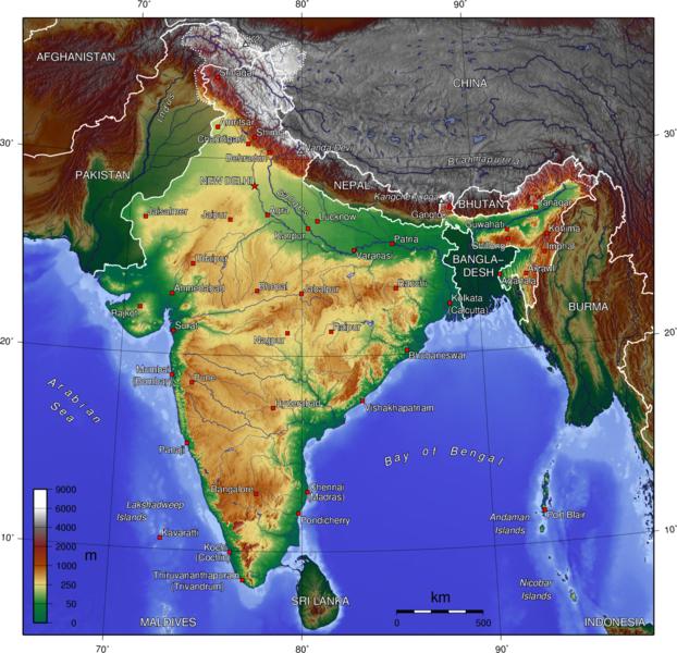
Question: Regarding India: there are mountain ranges on western India that average 400 meters to
1000 meters high. Even Bangalore is at an altitude of over 500 meters. Is all of India going to be
under water due to the plate movement or a combination of the plate movement (subduction) and
the overall rise in the water level? I'm very concerned about many people in India and if they can
get closer to the foothills of Tibet/Nepal but even in that scenario, that is going to be the new pole so
will be an arctic circle. What is the best to do for those there?
ZetaTalk Advice 7/3/2010: More than the country of India and Bangladesh and Bhutan will be pushed under the
Himalayas. Check the topographic map and see where the wrinkles are. This is where land has been rumpled as
something was pushed under it. Note that along the border with Burma and Tibet and Nepal, that the lands of India
are lowlands, where the land has been pushed down in the recent past. Why would the highlands of India be just in
the center of the country, and not border the high Himalayas? This is what will become of India and all on that
plate that is being pushed down and under. Those in India are advised not to seek high ground within Indian's
interior, but to head to the Himalayas, to Tibet and Nepal and China or the high mountains that are officially
Indian territory - Srinagar. Pakistan will also be high ground but the area will rupture to become a new seaway, so
this is unstable territory and the lowlands will be flooded during the hour of the shift.
Snow in Summer
Snow in Summer is a pole shift predictor. During the time of the last pole shift, this occurred, of record, in China. Written
during the reign of Emperor Qin c.1600 BC.
In the twenty-ninth year of King Chieh, the Sun was dimmed... King Chieh lacked virtue... the Sun
was distressed... during the last years of Chieh ice formed in mornings and frosts in the sixth month.
Heavy rainfall toppled temples and buildings... Heaven gave severe orders. The Sun and Moon were
untimely. Hot and cold weather arrived in disorder. The five cereal crops withered and died.
The Zetas have predicted that the seasons will blend into one another, and that snow in summer will occur. This is due, per
the Zetas, to the Earth wobble and a leaning away from the Sun so that the entire northern hemisphere gets a bit less
sunlight.
ZetaTalk Prediction 2/12/2000: As we stated in 1995, severe and intractable drought, drought and deluge swings.
Very cold summers, relayed in the past, in ancient reports of what the Chinese called a world cycle, meaning the
approach of another pole shift, where snow fell in summer.
ZetaTalk Prediction 9/19/2009: We have stated that the northern hemisphere will have cooler weather, winter and
summer, until the pole shift due to the push away of the N Pole daily by Planet X, which is nosing its N Pole toward
Earth. We have also predicted, for many years now, that snow will come in summer, and that the seasons will seem
to blend into one another.
Since Planet X arrived in the inner solar system in 2003 and put the Earth into a daily wobble, snow in summer has
increasingly been reported. The latest reports include snow in Austria on the eve of the Summer Solstice and a frost warning
in Oregon.
- Summer Snow: Austria Covered with Snow on the Eve of the Summer Solstice
June 21, 2010
http://oko-planet.su/pogoda/newspogoda/
- Last weekend western part of the country was covered with snow, traffic on some mountain passes
paralyzed. According to local media today, it is an unprecedented event for the republic, because unexpected
winter returned before June 21, that is, on the eve of the beginning of astronomical summer.
-
- Urgent - Weather Message
National Weather Service Medord OR
2:50 pm PDT Fri Jul 2, 2010
- Cold temperatures with frost expected … an unseasonably cold air mass will cause temperatures to fall low
enough for frost to form over the area late tonight through early Saturday morning.
Moon Orbit Extremes
The Moon has been at an extreme tilt since Planet X arrived in the inner solar system and began its outbound trek away
from the Sun. Per the Zetas, the Moon has a tilted orbit to avoid the crowded particle field around the Earth's middle, the
Ecliptic. This was outlined in Issue 140 of this newsletter last May 23, 2010, with supporting documentation. The extreme
tilt has, if anything, gotten worse. Photographs from Venezuela show the position of the Moon on June 29, 2010 at 10:16
pm. The Moon should have been almost due East, yet the photographer reports it was SE, way too far south. The Moon
on June 29 was between Full and New, and at these times is too far south. Note that the edge of the trees can just be seen
at the left hand side, as this will be used as a basis of comparison for the next photo taken just days later.
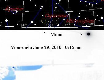
On Image the you can see I was looking SE, by the tree on the left, and the houses on the lower right
in the picture, that provide depth and angle to the moon shot. The camera time for this image on the
6/29/2010 reads 10:16:42 PM
The next photo was taken on July 4, 2010 just after midnight at 1:29 am and the photographer finds the Moon due east.
Note the trees at the left. Per Skymap the Ecliptic is at approximately at the same place and tilt during both these times. The
Moon should be along the Ecliptic at the same point, only varying by 5 degrees during the month. Yet by July 4, 2010 the
Moon has moved much further north, as the Moon was waxing toward the New Moon position. During its target="_top">extremely tilted
orbit, at Full and New Moon, the tilted orbit places the Moon where it is expected to be, the extremes of being too far to
the north or south only between these two points.
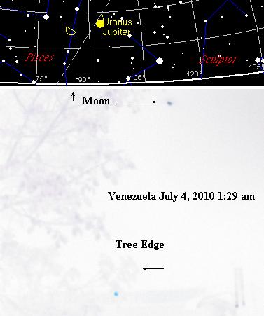
Today, 4th of July, the image reads 1:29:30 AM Venezuelan time, the Moon is due east. The picture
includes the tree in front of the window facing east, the place from where I am taking this picture.
You received this Newsletter because you Subscribed to the ZetaTalk Newsletter service. If undesired, you can quickly Unsubscribe. You
can always access prior Newsletters from the Archives.
|