The 7 of 10 arrived by the end of 2010. It presumably started
on December 23, 2010. The Zetas have stated that the sinking in
Indonesia would take 2-3 weeks to complete, start slowly and
pick up speed - 21 days. This is an interim report on January 4,
2011, at day 12, to document the sinking in Indonesia and the
Philippines.
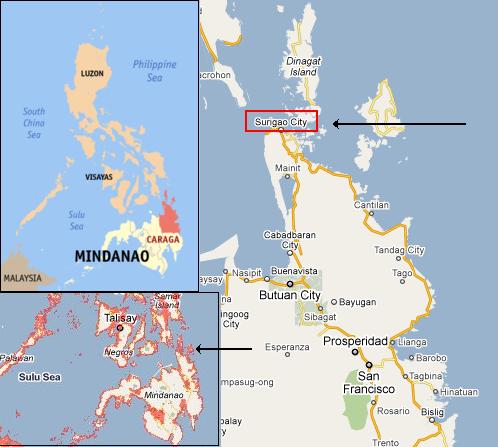
Philippines Sinking
On January 3, 20011 reports came in from several areas in the
Philippine of flooding, all of course for areas on the coast or
inland with access to the sea. Again, the rain is only causing
flooding in such areas, selectively falling on these regions,
apparently. For Caraga Region, the tip of this peninsula is all
lowland, with ocean access all around, so sinking there with
inundation from the sea could be disguised as flooding.
- Massive flooding hits Caraga region
January 3, 2011
http://www.pia.gov.ph/?m=1&t=1&id=9789
- As of press time, in Caraga
Region, all the four provinces are already experiencing
massive floodings while some portions of the said areas
are also experiencing minor landslides. In Surigao del
Norte a total of 47 families or 203 individuals in the
Barangays of Rizal, San Juan and Washington were
evacuated. In Surigao del Sur the municipalities of San
Miguel and Tago are already engulfed with water.
Flashflood occurred in San Miguel town. He also reported
that there are already barangays whose roads are not
passable anymore as of press time. In Butuan City, all
authorities and concerned agencies and individuals are on
red alert status.
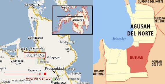
For Butan City and points southeast, there is a strip of lowland
extending all the way inland to the town of Agusan del Sur and
San Francisco. Note that once again the rains are claimed as the
cause, but the rain only seems to fall upon land that has access
to the sea? Here a river runs up along the lowlands into the
interior.
- Over 2,000 People Evacuated in Caraga
due to Floods
January 3, 2011
http://www.gmanews.tv/story/209609/over-2000-people-evacuated
- At least 2,009 people fled their
homes early Monday morning when two days of continuous
rains caused floods in San Francisco, Agusan del Sur and
Surigao City, Surigao del Norte in the Caraga region in
Mindanao.
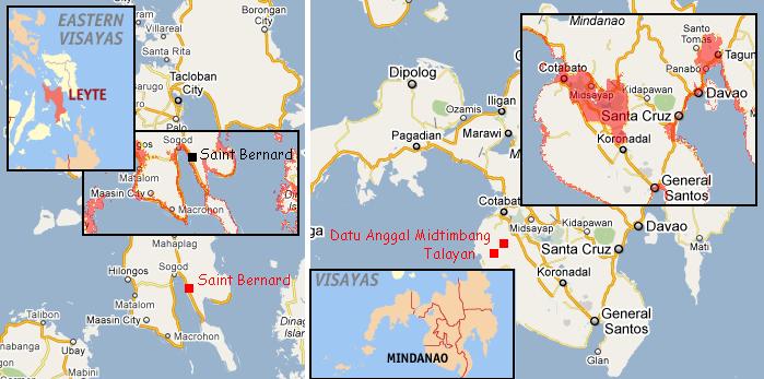
For towns in Mindanao and southern Leyte, the rule that
flooding only occurs in lowlands or lands with sea access via
lowlands holds. Talayan and Datu Anggal Midtimbang are in the
interior lowlands that lie between Cotabata and Santa Cruz.
Saint Bernard is on the coast in southern Leyte.
- Southern Leyte Town Under State of
Calamity
January 4, 2011
http://www.sunstar.com.ph/tacloban/local-news/southern-leyte-town
- The town of Saint Bernard in this
province was placed under state of calamity after three
people died due to massive flooding. Based on reports, the
three children were killed when their respective houses
were hit by flood and mud spawned by the heavy downpour.
Several barangays in Saint Bernard were hit by massive
floods.
-
- 6000 Families in Maguindanao hit by
Fashfloods
January 4, 2011
http://www.abs-cbnnews.com/nation/regions/01/03/11/6000-families
- An estimated 6,000 households from
2 towns of Maguindanao province were affected by
flashfloods after heavy rains. Residents of 8 barangays in
Talayan town and 2 barangays in Datu Anggal Midtimbang
town were affected.
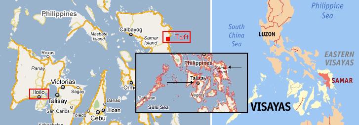
In the Visayas islands flooding along the eastern coast of
Samar Island and high waves reported near the port of Iloilo
indicate sinking, a rising sea, with the turmoil in the water
that such adjustments can make. Once again, these areas
reporting flooding, ostensibly from rain, are all on the
coastlines and with access to the sea. Without exception, this
has been the case for the flooding reported in the days after
the New Year in the Philippines.
- Floods, Landslide Render Roads in
Several Areas in Samar Unpassable
January 2, 2011
http://www.pia.gov.ph/?m=1&t=1&id=9707
- Continuous heavy rains have
already triggered flooding and landslide in several parts
of Samar province. Barangays Burak, Binaloan, San Pablo
and Malinao, all at the municipality of Taft, Eastern
Samar are already heavily flooded. The rains may cause
flashfloods and landslides in the Visayas. It also issued
warning of strong to gale force wind that is expected to
affect the Eastern Seaboard of Visayas, with rough to very
rough sea condition.
-
- Over 200 Passengers Stranded in Iloilo
Port
January 3, 2011
http://www.sunstar.com.ph/breaking-news/over-200-passengers-stranded
- More than 200 passengers were
stranded in the Mulle Loney Port in Iloilo City after a
fast craft halted its trip bound for Bacolod City. In a
Bombo Radyo report, it was learned that the fast craft
owned by Weesam Express had started its trip for Bacolod
City but it came back to the port due to the huge waves.
The craft's captains decided not to continue the trip
after some passengers suffered headaches due to the waves.
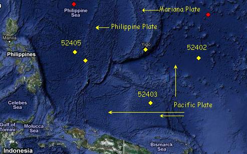
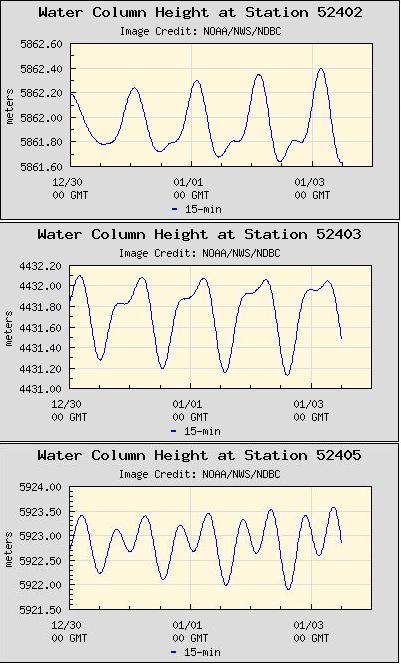
Certainly the buoys to the east of the Philippines indicate
action, as the sea flood is dropping there, water on the rise!
The buoys above New Guinea, in the Pacific, likewise indicate a
rising sea level. What could this mean?
ZetaTalk Analysis
1/4/2011: There is indeed a relationship
between the high waves and flooding in the Philippines in
those towns along the eastern coastline and inland with access
to the sea. The Philippines have begun to sink, though such
sinking is never such that an entire land mass or large island
sinks uniformly, so can be deceptive. There is an additional
influence from the tilting of the Philippine Plate and
continued compression out in the Pacific, so that water is
heaped to the east of the Philippine Islands, and is washing
over their eastern shores during equalization of the water
level. However, this latter is a relatively small influence.
The issue with flooding is absolutely due to a dropping in
elevation for some parts of the Philippines.
Malaysia/Sumatra
Buckling
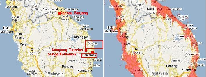
Flooding along the eastern coastline of the Malaysian peninsula
started late December 31, 2010 and worsened greatly by the
following day, New Years Day on January 1, 2011. Two areas were
primarily affected - the Dungun district and Rantau Pajang near
Kota Bahru. Kota Bharu lies near the mouth of the Kelantan
River, and Rantau Pajang is on this river, thus
backwash from rising sea waters would cause flooding there. Both
these areas are thus lowlands with access to the sea. Where the
flooding is blamed on rain, it seems the rain only falls
selectively on lowlands with access to the sea. Reports included
of a rise up to 15 meters high at times.
- Dungun District Flooded
January 1, 2011
http://www.malaysiandigest.com/component/content/article/36-local/14401
- Several houses in Kampung Cacar ,
Paka in Dungun district were flooded following heavy
rainfall overnight. The houses affected are located in a
low lying area. Victims were evacuated last night after
SungaiKemaman overflowed its banks submerging the kampung
in 15m of water.
-
- More Victims Evacuated As Flood
Conditions Worsen In Dungun
January 1, 2011
http://www.malaysiandigest.com/component/content/article/36-local/14415
- Flood conditions in Dungun,
Terengganu worsened as the number of flood victims
evacuated increased. Two days ago Kemaman was hit by flash
floods.
-
- More Evacuated In Rantau Panjang
January 1, 2011
http://www.bernama.com.my/bernama/v5/newsgeneral.php?id=553675
- The number of flood victims
evacuated in Rantau Panjang saw a sharp increase compared
with this morning, when the total reached 280 people at
4pm.
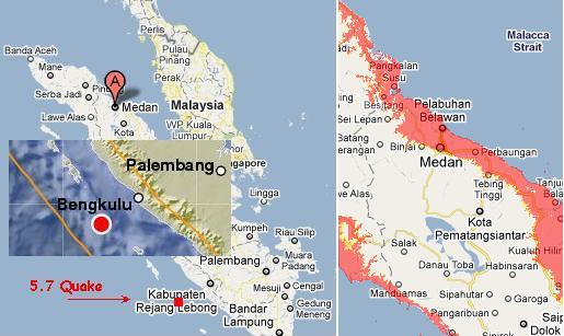
North Sumatra is sinking and crumbling under the pressure of
its land mass being forced down and under the curve of the
Indo-Australian Plate. The signs include the eruption of Mount
Sinabung, which has been quiescent for 400 years.
- Indonesian Volcano Erupts after 400
Years
January 2, 2011
http://www.allvoices.com/contributed-news/7769994-indonesian-volcano
- An Indonesian volcano, Mount
Sinabung, north of Sumatra Island, spewed ash and lava on
Sunday morning, followed by another eruption early Monday
morning. The volcano erupted after four hundred years,
causing panic in villages.

Simultaneous to this was flooding in and around Medan, which is
on the coast in northern Sumatra, and not more than 30 miles
away from the erupting Mount Sinabung. Of course, as has been
the cover in Indonesia, braced for the ZetaTalk 7 of 10
prediction to unfold, it is all blamed on rain.
- New Year, Hundreds of Houses in Medan
Awash Flood
January 2, 2011
http://www.detiknews.com/read/2011/01/02/153135/1537589/10/tahun-baru
- Due to heavy rains for two days,
hundreds of homes on the banks of the River Deli, Maimun
Medan, North Sumatra (North Sumatra) flood. Height of
water in the home can reach an adult's knee. Three
villages are flooded on Sunday (2/1/2010), is Aur, Kampung
Baru and the Dead River. Heavy rains in upstream areas
resulting in surface water in the river that crosses Deli
residents suddenly overflowed. Flooding is not due to
heavy rain in Medan alone. But the rains also bring
upstream flood.
ZetaTalk Analysis
1/4/2011: Prior to the end of 2010,
starting on December 23, 2010, sinking along the southern
coast of Java was evident, with no remission in this flooding
a week later on December 29, 2010. Now there is evidence of
flooding along the eastern shores of Malaysia and the eastern
shores of northern Sumatra. The incidence of flooding on the
coastline of eastern Sumatra occurred on the same day as a new
volcanic eruption on a volcano previously inactive for 400
years, just 30 miles from the flooding in Medan, and a 5.7
quake occurring offshore along the border with the
Indo-Australian Plate nearby. Just the day before flooding
along the eastern coast of Malaysia was reported, again only
in those areas on the coast or with access to the sea. Why are
some areas seemingly exempt from sinking and flooding while
others sink?
We have explained that the land masses of Sumatra and Java
have been formed from rubble, when the plate tongue holding
Indonesia was pushed down and under the curve of the
Indo-Australian Plate in the past. Rubble does not act as one,
but adjusts more like settling gravel, a bit here then a bit
there. Why would the eastern coast of Malaysia be affected,
but the west coast facing Sumatra be exempt? The issue of the
plate holding Indonesia folding like an accordion came up in November, 2010
when Bangkok, Thailand experienced flooding that refused to
drain while a new island merged near Bali. Our explanation was
the accordion folding of the tongue holding Indonesia, under
intense pressure from the compressing Pacific. Follow the line
folding the valley of Thailand down a bit further and you
arrive at the eastern coast of Malaysia.
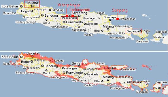
Java Increasingly
Sinking
Where the southern edge of Java bagan sinking before the end of
2010, so that all flood zones were on the souther
side, with coastal access or lowlands with access to the sea,
reports of flooding have now switched to then northern coast of
Java and Bali. These islands are sinking first on the cutting
edge of the plate tongue holding Indonesia, but the island are
continuing to sink, steadily. Note that in all cases flooding
is either along the coastline or in lowlands with access to the
sea.
- Natural Disasters Greet the New Year!
January 2, 2011
http://suaramerdeka.com/v1/index.php/read/news/2011/01/02/74486/Bencana
- From the data collected today
floods occurred in the District Kedungwuni and
Wonopringgo. Flash floods that occurred in Kedungwuni due
to overflow of river and Sengkarang Welo. Flood hit homes,
crops and livestock jewan in Pakis Putih Village and part
of Hamlet Kranji (East Kedungwuni). In Hamlet Village
Plutungan White Ferns a location that is most severely hit
by flash floods because it is located in the Welo River
basin around until Sunday afternoon [Jan 2], is still
flooded.
-
- Hundreds of Houses in Sampang Flooded
Floods
January 2, 2011
http://www.mediaindonesia.com/read/2011/01/02/192462/125/101/Ratusan
- Hundreds of homes in three
villages and one village in the town of Sampang, Madura,
East Java on Sunday [Jan 2] flooded to a depth of 1 meter.
Floods caused by heavy rain which flushed the city and the
region is higher in the northern district of Sampang to
cause Myrtle River overflowed.
-
- Floods rage in Four Villages in
Pekalongan
January 2, 2011
http://www.mediaindonesia.com/read/2011/01/02/192434/124/101/Banjir
- Heavy rain which flushed since
Saturday [Jan 1] night resulted in the volume of river
water Sengkarang, Pekalongan, Central Java increased
sharply and the dike collapsed. As a result, hundreds of
houses in four villages hit by flash floods up to hundreds
of families displaced.
-
- Bali`s Floods Kill a Man and Destroy a
Bridge
January 1, 2011
http://www.antaranews.com/en/news/1293900727/balis-floods-kill-a-man
- Flash floods that hit the western
part of Singaraja town in Buleleng district, Bali
province, on Friday, have killed a local resident and
destroyed a bridge. The flood waters strong currents also
carried tens of cows and caused Kzetut Sempiran,
60-year-old resident of Angsa Sari hamlet in Titab
village, to go missing, he said. The deadly floods hit
some parts of Buleleng district after torrential rain
showered the area.
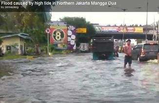
To the extent possible, sinking land is being disguised as
flooding from rain. But note that the roadway in Jarkara, the
Jl. R.E. Martadinata, is being reports as inundated with sea
water, and a tourist captures the astonishing influx from
the sea on a video, posted on YouTube.
- Flood caused by high tide in Northern
Jakarta Mangga Dua
Dec 30, 2010
VIDEO: http://www.youtube.com/watch?v=i-cOrVTo_bE
- Traffic jam is quite common there.
But for a less than 2Km stretch, the jam was about
1.5Hrs... it was pretty scary as I was on my way to the
airport. Main reason is the overflow of sea water onto the
road plus a stretch of 5 lanes merging into 1 that caused
this.
- Jl. R.E. Martadinata in North Jakarta
Flooded
January 3, 2010
http://www.thejakartapost.com/news/2011/01/03/jl-re-martadinata
- Sections of Jl R.E. Martadinata in
North Jakarta are under 30 centimeters of floodwater,
which has disrupted traffic from Tanjung Priok Port and
Mangga Dua. The street became awash with floodwater Monday
after the Japat River overflowed. Motorists are warned to
exercise caution when traveling along Jl. R.E. Martadinata
due to the presence of potholes
You received this Newsletter because you Subscribed
to the ZetaTalk Newsletter service. If undesired, you
can quickly Unsubscribe.
You can always access prior Newsletters from the Archives.
|