Sunrise Early
In the far reaches of the north the Sun is not seen for many days during the winter months. In these
places, the exact day when the Sun will again make an appearance is known, like a celebration. This is
the case for most of Greenland, northern Norway, and for Barrow, Alaska. The issue first arose when
residents of Ilulissat, Greenland saw the Sun make an appearance two days ahead of schedule. Scientists
speculated that the ice sheet had shrunk due to Global Warming, an explanation the Zetas called
hogwash.
- Strange Claim: The Sun Rose 2 Days Early in Greenland
January 18, 2011
http://news.yahoo.com/s/livescience/20110118/sc_livescience/
- Residents of a town on the western coast of Greenland may have seen the sun peek over the
horizon 48 hours earlier than its usual arrival on January 13, sparking speculation, and
disagreements, over possible causes. The town of Ilulissat sits just above the Arctic Circle,
meaning its residents had been without any sunlight for a good chunk of the winter, and
traditionally they'd expect to see their "first sunrise" on January 13. News that the sun had
peeked over the horizon on January 11 appeared online in British and German-language
publications. Of about half a dozen scientists contacted, most were unaware of the report,
which was circulating on the Internet. They offered a number of hypothetical explanations,
including an illusion caused by an atmospheric effect and conflicting opinions about
whether global warming might be to blame for melting along the edges of Greenland's ice
sheet. With less ice, Greenland's elevation may take a dip such that the sun would have less
distance to travel before appearing over the horizon.
ZetaTalk Explanation 1/22/2011: Of course this is from the Earth wobble, which has gotten
increasingly violent and extreme. Greenland is tilted toward the sunrise, on a daily basis, due to
the wobble. This is normally not noticed except during such precise measures, as the exact day
when the Sun is traditionally seen during the waning winter in Greenland. To assert that the
reason for this is melting ice is absurd. A simple computation would show the absurdity. More
than the ice sheet would need to be removed. The curvature of the Earth would have to be
altered.
If the ice sheet were the reason in Greenland, then what would be the reason for a similar early
appearance of the Sun in Norway and Barrow, Alaska? The Sun appeared two days early in Barrow,
Alaska too, which was dismissed as a "false sunrise" by the establishment.
- 'False Sunrise' Whets Expectations for Sun's Reappearance in Barrow
January 21, 2011
http://www.alaskanewspapers.com/article.php?article=1103false_sunrise
- No, the sun hasn't made an early appearance in the nation's northernmost community,
though a glowing mirage and misleading Internet information may have given the
impression that round-the-clock night has ended for now. The magic moment of the sun's
return, a time of tequila-sunrise parties as Barrow residents toast the light blushing the
horizon, will come this Sunday afternoon [Jan 23] at 1:05 pm, said Dave Anderson, official
in charge at the community's National Weather Service office. It will set at 2:14 pm,
according to Anderson, who gets his information from the US Naval Observatory web site.
But last Sunday, some locals got sneak peaks of the new sun.
And then there is the documented case of the Sun making its reappearance in Tromsø, Norway a full day
early. Once may be a coincidence, twice a pattern, but thrice is a definite pattern.

- Welcome Back, Dear Sun
January 20, 2011
http://www.itromso.no/nyheter/article423177.ece
- At 11:57 am. The plan would she show up first in the morning. But it was like she knew that
the weather forecasts for Friday [Jan 21] was not the good kind, and realized that she
therefore had to show off today {Jan 20]. And she was as beautiful as ever as she beamed
to us in a few small minutes. Velkommen tilbake, kjære sol.
Australia Awash
The undulating Indo-Australian Plate - which is tipping up along its eastern edge near Fiji and the Coral
Sea, then dropping back down, then rising again - is causing the flood waters that inundated Queensland
a month ago to slosh around in the outback. This is described as an "inland sea" in the press.
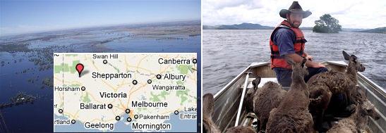
- Inland Sea Menaces Victorian towns
January 22, 2011
http://www.abc.net.au/news/stories/2011/01/22/3118818.htm
- Victorians are being warned that a massive moving inland sea is expected to threaten
towns in the state's north and north-west for up to 10 more days. Floodwaters are now
heading for the Murray River town of Swan Hill. The state's flood crisis is about to enter its
third week and according to authorities it still has a long way to go. It is estimated the
moving inland sea is 90 kilometres long and 40 kilometres wide. Communities in Victoria's
north including Benjeroop, Murrabit and Mystic Park are now preparing for major
flooding. Further downstream near the border with New South Wales floodwaters are
beginning to rise at Swan Hill.
-
- Swan Hill Braces for Vic Floodwaters
January 22, 2011
http://news.smh.com.au/breaking-news-national/swan-hill-braces
- Floodwaters are inching towards the northwestern Victorian city of Swan Hill as the
swollen Loddon River continues to plague parts of the state.
The buoys show the Coral Sea and the Caroline Plate just north of New Guinea are now rising again,
after having dropped for several days. Even the Pacific Plate to the northeast of the Caroline Plate is
rising! This would tip Australia such that water trapped inland would have no choice but to flow south.
And flow south it has! The inland sea is heading toward Melbourne now, trapped in the grip of undulating
plates.


Flooding Status
Taking into account all news articles to date, this is the status where flood water that refuse to drain and
high tides scouring inland have been reported. As an example, as noted in this article from the island of
Borneo, the flooding that occurred on January 18, 2011 is still present 10 days earlier, to a depth of 12
feet.
- Malaysia:Many Roads in Niah District Still Flooded
January 26, 2011
http://www.theborneopost.com/?p=89762
- Flood water still inundated roads leading to 27 villages or localities with some 2,649
population in the Niah district, causing difficulties to obtain food rations and carry out
daily chores. The water level as at 4pm yesterday was still very high, between one to 12 feet
at some stretches, making it impassable to small vehicles.
The sinking continues to spread to new areas, and deepens in areas already affected.


Sea Waters Admitted
The excuse that flooding along coastlines is caused by rain, in the lands on the plate tongue holding
Indonesia, does not hold, as the flooding does not drain. And the excuse that it is caused by storm surge
or high tides also fails when the flood water fails to drain and tides refuse to change the situation. So now
the excuse has moved to be rising seas caused by Global Warming. However, just why Global Warming
would cause such an extensive rise just on those lands residing on the plate tongue holding Indonesia is
not addressed. In both the Philippines and Java, admissions that the flooding is caused by land
"submerged in seawater" or due to "increased sea levels" is appearing in the press.
- Philippines: Some Coastal Areas, Islands in Caraga Sinking Due to Rising Sea Water Level
January 22, 2011
http://cc.rsoe.hu/index.php?pageid=news_read&hirid=563
- Shorelines in coastal areas in Caraga Region are slowly disappearing as they are being
submerged in seawater because of rising seawater. This is according to two
non-government organizations (NGOs) involved in climate change adaptations and disaster
preparedness initiatives. NGO Green Coalition said they observed shores along coastlines
in three Caraga provinces - Surigao del Sur, Surigao del Norte and Agusan del Norte - were
slowly disappearing as rising seawater is already eating up shores by at least 10 meters and
in some areas as long as 30 to 50 meters.
-
- Java: Increased Sea Levels in North Jakarta Admitted by the Government.
January 22, 2011
http://www.detiknews.com/read/2011/01/22/201129/1552381/10/
- Two burst levees in North Jakarta were due to increased sea levels. Jakarta Governor
Fauzi Bowo visited two locations, namely Levee Kalibaru, Cilincing, and Levee Muara
Baru, Penjaringan, North Jakarta. Burst leeves inundated hundreds houses. More leeves
are being built to overcome floods 2011.
-
- Java: Rob Soaking Six Villages in Seram
January 27, 2011
http://www.metrotvnews.com/metromain/newsvideo/2011/01/28/
- Metrotvnews.com, East Seram: Bula Six villages in the district, eastern Seram District,
Maluku, rob inundated. Cause, sea water-retaining embankment at the Beach District Bula
broken. Although long-broken, yet no improvement of East Seram regency government.
-
- Java: Soak Sea Water 269 Houses in Sikka
January 26, 2011
http://www.metrotvnews.com/read/news/2011/01/26/
- As many as 269 homes, seven schools and two mosques are spread out in seven districts in
Sikka district, Flores island, East Nusa Tenggara submerged in sea water due to tidal
waves that have occurred.
Meanwhile, central Java had its first ever crop circle! Which the Zetas say is warning people in the
highlands to expect refugees from the coastline.
- Indonesia Space Agency Pooh-Poohs Idea that Aliens Behind Crop Circle
January 24, 2011
http://www.thejakartaglobe.com/home/indonesia-space-agency-pooh-poohs
- Hundreds of curious visitors have flocked to a small rice field in central Java to witness
what could be Indonesia's fist documented crop circle. According to several residents, they
saw a tornado. Budi Waluyo, head of the Meteorology, Climatology and Geology Agency
(BMKG) in Yogyakarta, said the agency had no records of a tornado in the special province
or its surrounding areas. He said even if a tornado did occur, it would leave a distinctive
snaking trail, not a crop circle.

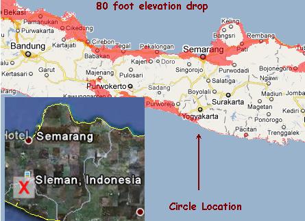
ZetaTalk Explanation 1/29/2011: When the sinking expected for Java completes, there will be
many refugees, pouring into the highlands from both coasts. This will affect the people of
province of Yogyakarta and the highland town of Slemen where the circle was laid. The narrow
waist in the island of Java will drive refugees toward this area, particularly as major roads lead
there. Be prepared to host these refugees, was the message this crop circle relayed.
You received this Newsletter because you Subscribed to the ZetaTalk Newsletter service. If undesired, you can quickly
Unsubscribe. You can always access prior Newsletters from the Archives.
|