Magnetic Dance
The Zetas have been asked, in the past, about the antics of the Earth's magnetic field as displayed on the Magnetic Simulator
in Japan. The normal field has what appears to be wings flowing outward at the top and bottom, the light blue lines represent
magnetons from the N Pole of Earth and the red lines represent their return to the S Pole of Earth. These wings are blown
outward, away from the Sun, by the solar wind. As the N Pole of Planet X is turned increasingly toward Earth, this forces the
Earth to deal with a blast of magnetons, turning the simulator graphic white hot, as shown on May 10, 2011 at 15:03 UTC.

ZetaTalk Explanation 8/21/2009: This crowding can be shown in the blast of magnetic particles that have been
recorded periodically since January 21, 2009. There are harmonics that occur when two magnetic fields encounter
each other. The fields clash and divert the magneton flow temporarily if they cannot merge in an alignment.
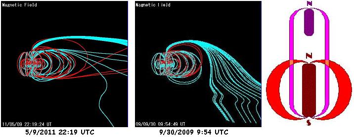
To deal with the press of magnetons coming from the N Pole of Planet X, Earth may allow her magnetic field to simply go
end-to-end with the larger field of Planet X. This causes the Earth to seemingly lose its S Pole altogether. This was the case
on May 9, 2011 at 22:19 UTC.
ZetaTalk Explanation 9/30/2009: Any plot of a magnetosphere will show output from the N Pole, regardless of what
activity might be ongoing at the S Pole. Magnetons flow out from the N Pole, circle round, and return at the S Pole.
What would cause the Earth's magnetosphere to temporarily show only an outbound stream (blue lines), and this
almost entirely turned quickly in space toward the direction of the Earth's magnetic S Pole rather than arching out
into space before returning, but then bypassing the Earth's S Pole? It is as though the magnetons are diverted away
from returning to the Earth's S Pole, and this is what is occurring.
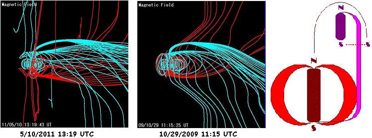
The Earth seldom goes end-to-end, and then only briefly, more often slipping into a shared field. This is where the magnetons
hosing out from the N Pole of Planet X return to Earth's S Pole seemingly from above, giving the Earth's magnetic field a
twisted appearance. This was the case on May 10, 2011 at 13:19 UTC.
ZetaTalk Explanation 10/29/2009: What would explain the magnetic twist, where Earth's field appears to be heading
in the wrong direction entirely, the emissions from the N Pole going directly south, the intake at the S Pole coming
directly from the north? Some magnetons from the N Pole of Planet X, which has a wide field, drift to the S Pole of
Earth rather than travel on to the S Pole of Planet X.
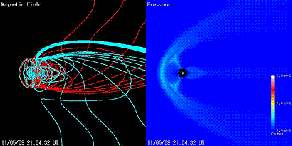
Where these anomalies have shown up occasionally - the blast, the end-to-end, or the shared field - the Earth's magnetic field
is predominantly in its normal winged shape, without any evidence of a white hot blast. But things are obviously heating up.
During a 24 hour period - May 9, 1011 21:04 UTC to May 10, 2011 19:04 UTC - all variations made at least one
appearance. What kind of a magnetic dance is the Earth enduring?
Caribbean Borders
The S American roll is poised and ready, which can be seen by where disasters are occurring. Curiously clustering around
May 3, for instance. Did the roll press forward on that date? These disasters outline the borders of the Caribbean Plate and
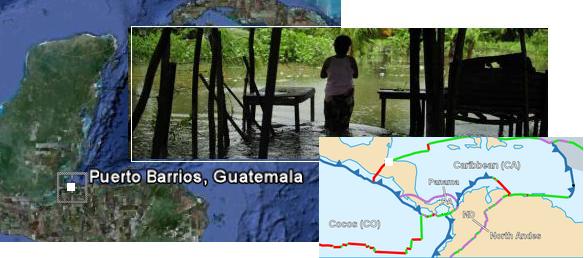
go down along the N Andes Fault Line. Starting at Guatemala, where the rainy season began but do note that the first flush of
flooding has started just on the Caribbean border where it cuts through Guatemala, and nowhere else! WeatherUnderground
indicates thunderstorms but no measureable precipitation. Why did it flood just in Puerto Barrios?
- Torrential Rains Leave 2,390 Affected in the Guatemalan Caribbean
May 03, 2011
http://www.aguasdigital.com/actualidad/leer.php?idnota=3818454&efenew=1
- It rained hard for five hours in Izabal which increased the river flow Escondido brought down the drains in the
urban area of the city of Puerto Barrios. The rainy season began in 2011, which lasts until October. In
mid-May is scheduled to open in rainfall in the central plateau, which includes the capital, while on the Pacific
coast will be the end of the month, and in the north at the beginning of June.
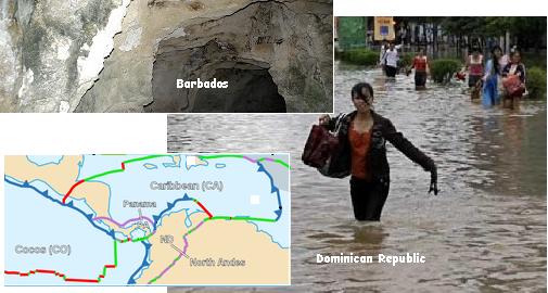
Moving across the northern border of the Caribbean Plate we encounter the Dominican Republic where a mere 80 mm
(.31") of rain brings an odd flash flood and warnings of "abnormal waves". This would be the case if the Caribbean Plate had
tilted slightly, as the Dominican Republic is on the northern lip of the Caribbean Plate. Again, the date is May 3. And yet
again on this date, a sinkhole opened up on the island of Barbados, one of the islands cited by the Zetas to have significant
elevation loss during the S American roll. Barbados does have sea caves along its coastline, so a sinkhole would not be
surprising if the rock is squeezed from the side and pushed down.
- Dominican Republic: Flash Flood Warning Issued in High-Risk Areas
May 3, 2011
http://encarpeta.net/noticia.php?id_noticia=778&sesion_periodico=55
- It is expected that the cumulative rainfall in the next 24 hours could exceed 80 mm, causing urban flooding.
As sea conditions in the Atlantic and Caribbean coasts, fragile and small vessels should navigate with caution
near the coast and not to venture offshore by waves abnormal.
-
- Sinkhole Opens up in Barbados
May 3, 2011
http://news.caribseek.com/Barbados/Daily_Nation/article_93237.shtml
- Since late last year the yard started cracking up, then the back step started shifting, or rather moving out of
place. The hole seemed very deep.
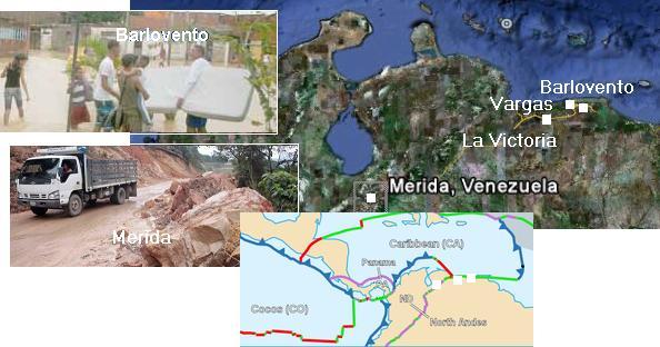
Then along the top of Venezuela, where the border with the Caribbean Plate skirts along. In Barlovento, La Victoria,
Merida, and Vargas flooding occurred on that fateful day, May 3. But the crumbling along the plate edge can create
blockages in rivers and streams, funneling water in unexpected directions. Merida is also right on the N Andes Fault Line.
- New Flood in Barlovento
May 03, 2011
http://www.diariolavoz.net/seccion.asp?pid=18&sid=438¬id=360547
- Floods, landslides, slope, landslides, collapse of houses, roads blocked by logs and debris carried by the
stream, are the product of the heavy rain still falling in the area of Barlovento, Miranda state.
-
- Civil Protection cleared the highway again Valencia-Puerto Cabello
May 3, 2011
http://www.eluniversal.com/2011/05/03/242-viviendas-afectadas
- 242 homes were flooded after the Aragua river flooded. The level of water accumulated in the streets reached
up to one meter in height. Also reported in the pediatric emergency contingency Hospital in the city of La
Victoria, due to the entry of water, a situation that limited medical services for several hours.
-
- Mocotíes River Left a Woman Dead in Merida
May 3, 2011
http://www.eluniversal.com/2011/05/03/aguas-del-rio-mocoties
- The downpour caused severe damage to roads, hundreds of homes and other infrastructure. Rainfall has
claimed the life of a woman. She slipped and fell into the river Mocotíes, being washed away by raging waters
about 3 miles.
-
- Harold Flores was Swept Away by the Floodwaters
May 3, 2011
http://www.eluniversal.com/2011/05/03/un-desaparecido
- The most critical situation was on the east coast, rivers overflowed Guayabal, Chuspa and La Sabana,
landslides were impeding the Road Coast, and was reported as missing a vacationers.
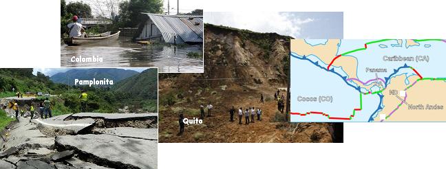
If the Caribbean Plate moved on May 3, the N Andes Fault Line has been consistently active. On the fault in Colombia,
roads are twisted and heaving river bottoms, dammed the rivers and sending water in new directions. In Ecuador at Quito,
also on the fault, a horrific landslide occurred. If floods and landslides and sinkholes are all that common in the region, then
why are they just occurring on the plate borders or fault lines?
- Shattered Road in Pamplonita
April 28, 2011
http://www.laopinion.com.co/noticias/index.php?option=com
- From Easter began to evince a geological fault collapsed a considerable stretch of road. Many landslides are
on the road and down hills water jets that resemble waterfalls or streams.
-
- Increase to 14,300 Affected Families
April 29, 2011
http://www.eluniversal.com.co/cartagena/bolivar/aumentan-14300
- The official said that the emergency is almost immeasurable, and warns that the rapidly growing number of
people affected due to floods do not stop.
-
- Landslide in Quito Killing 5 People
May 5, 2011
http://www4.elcomercio.com/2011-05-02/Noticias/Quito/Noticia
- New landslide occurred in the prospectus, Simon Bolivar. At the moment, confirmed the death of five people.
Four of the victims belong to the family of Machachi. Husbands Jorge Askel and Mary Magdalene Cañizares,
along with his son Miguel Askel, drove past in a red wagon, when the mountain collapsed.
Borneo as Preview
During the Katrina disaster, when New Orleans was flooded, the Zetas described this as a pole shift preview.
ZetaTalk Description 9/2/2005: We have described from the start of ZetaTalk a situation where the coastlines and
river basins will be massively flooded during the pole shift. All this seems fantasia to many, despite the physical
evidence that such flood tides have happened in the past. New Orleans is an example of how water and wind can
wreck a city and make all the former residents homeless, in a wink.
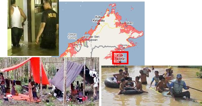
Something similar has happened to the citizens of Kalimantan, on the island of Borneo. This area, under water as the land
sinks 80 feet (which it is in the process of doing) suddenly finds itself without police protection. They are camping in
makeshift tents and fashioning bamboo rafts. Once again, a pole shift preview of what is to come, worldwide.
- Flood Victims Need Help Banjar
May 05, 2011
http://berita.liputan6.com/daerah/201105/332847/korban_banjir
- Thousands of head of displaced families in poor condition due to delayed aid. Residents who live in makeshift
camps also begin developing the disease. Flooding had grown so high that most residents roofs look no
further. Flooding also crippled public services sector. Flood-foot police activity has ceased to serve the
community.
-
- Seven Districts in South Awash
May 05, 2011
http://berita.liputan6.com/daerah/201105/332797/tujuh_kabupaten
- The floods that hit the South Kalimantan until now no sign of receding. Noted already more than 800
households or more than 3,400 people in three districts in the Banjar District was forced to flee to places such
as schools, places of worship, to camping in the jungle rubber. The refugees complained about the lack of
assistance they receive. In addition, tens of kilometers of roads and villages inundated, thus making the
citizens of many who use the services of a bamboo raft to penetrate the road.
The Zetas have often stated that many who hear their warning about the coming pole shift are in denial on what the state of
affairs will be. Take a look at the photos of life in Kalimantan, and put yourself in that picture!
ZetaTalk Prediction 12/15/1995: After the cataclysms the snug blanket of protection that many have taken for
granted will be gone - no Social Security checks, no home deliveries, no 911 emergency service, no free medical
services, and no welfare checks. For those not relying on those services the shock will be as great, as with home, job,
and service providers gone they will be just as destitute and bereft. In essence, humans will be relying on one
another, and not on an infrastructure.
ZetaTalk Prediction 2/15/2001: In countries where social services exist, those desperate for a rescue will begin to
assume that the government will act, perhaps at the last minute but in time to rescue them. Announcements will be
made to peacefully evacuate cities and coastlines, tents will be erected, and the populace resettled after it is all over
with the worst of it the beans and rice endlessly served for supper. The military, politicians, and those holding stakes
in the cities and coastlines being deserted will put selfish interests aside and become humanitarians, in the end. For
those clinging to this hope for rescue, we would only point out that the governments today do not act in this manner,
but leave many starving children and injustices in their wake, daily.
New Video Clips
 The Zeta Report 47 - 7 of 10 progress, stages 1 done, 2-3 in process. The Zeta Report 47 - 7 of 10 progress, stages 1 done, 2-3 in process.
Added May 9, 2011. On YouTube
 The Zeta Report 46 - Skinny Bob, the Roswell Zeta survivor.! The Zeta Report 46 - Skinny Bob, the Roswell Zeta survivor.!
Added May 9, 2011. On YouTube
You received this Newsletter because you subscribed to the ZetaTalk Newsletter service. If undesired, you can quickly Unsubscribe.
|