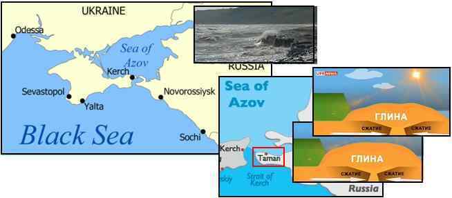
Sea of Azov Squeeze
As is known, the Eurasian Plate is being pulled apart in the region of Belarus and the Ukraine, as featured in Issue 255 (Kiev)
and Issue 257 (Belarus) just last week. Do listen to the brief audio clips if you have not already done so. Now a new
phenomena has emerged, land emerging near the straits of the Sea of Azov nearby, as noted in this Pole Shift ning blog.
- Russia Has More to 4N for Underground Shift
August 31, 2011
http://www.lifenews.ru/news/68226
- The plot of the seabed up to the surface in the vicinity of the Taman Peninsula. The new land emerged from
the shift of tectonic plates. Amazing natural phenomenon has been documented in recent days. Huge beds of
clay and stone rose by about 5 meters above the Sea of Azov in the Temryuk district of Krasnodar region,
forming a peninsula. The huge strip of land length 800 and width 50 meters literally grew up on the very spot
where, just a week ago, lapped the Sea of Azov. Seismologists believe that under the influence of yet unknown
force tectonic plates began to converge and squeeze out a layer of clay. Pressure, which could set in motion a
volume of soil, according to conservative estimates, was equal to 24 million tons.
If one follows the direction of the Dniepier River and the Volga/Don Rivers as they descend toward the Black Sea, they are
pointing at the location of this heaving landrise, and the Zetas explain. Once again, no human had an adequate explanation.
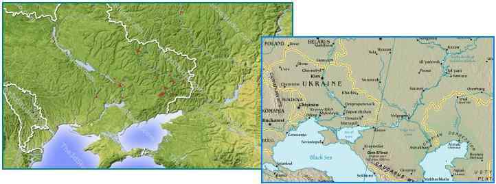
ZetaTalk Explanation 9/3/2011: As is clear from the Kiev trumpets and the horn of Homel in Belarus, this part of the
great Eurasian Plate is pulling apart, a stretch zone. A quick glance at geography shows why. Though the Dniepier
River descending from the Ukraine diverts to the Black Sea, and the Volga River descending from Russia diverts to
the Caspian Sea, it is clear that both are pointing at the Sea of Azov. The entire region, including the Black Sea, the
Caspian Sea, and the rivers feeding them is part of a stretch zone. River channels indicate a weak point in the crust,
a point where pulling apart is most likely to happen. As the Sea of Azov is at the tip of this triangle of descending
rivers, the stretch is likely to play like a pin-pong game there, a tug and release action at the straits near Taman.
Where most stretch zones are pulled in a single direction, such as the East Coast of the US being pulled directly east
toward the Atlantic Rift, stretch zones can compete, and in such cases vibrations occur. Florida is being pulled east
and also southwest due to the Caribbean Plate edge lifting at the Gulf, providing an alternate route. Thus, the
Tampa Bay howl recently recorded, due to the vibration during competition. In Belarus and the Ukraine, likewise,
there is competition, as a complex drama is playing out during the 7 of 10 scenarios. This stretch zone is pulling east,
at somewhat of a diagonal toward the southeast as the Eurasian Plate border runs down along Turkey and beneath
Iran. At the same time, because the African Plate will be dropping and pulling to the west as it does so, there is a tug
in this direction. Thus, the vibrations in Homel and Kiev.
The straits near Taman are actually being pulled in three directions. First southeast along the Eurasian Plate border,
then a bounce back to the northwest when the tug releases, then a tug to the southwest when the African Plate tends
to drop and move slightly to the west during the African roll, which has already started to a slight degree. Pull a
piece of cloth with a hole in the center over some dough, and pull alternately in three different directions, and see
what the dough does. As the cloth is pulled in one direction, the cloth is pressed down, and the dough moves away
from that spot to the obvious outlet, the hole in the center of the cloth. Likewise for the other directions, so the
dough at the center gradually squeezes out. The strait at Taman is clearly a weak point in the crust, equivalent to the
hole in the cloth.
But wait, there's more! Now a mud volcanoe has also appeared in the Sea of Azov, caught on video as fleeing bathers
frantically ran from the mud explosion, as reported in this Pole Shift ning blog. Exciting times in the stretch zone of eastern
Europe!
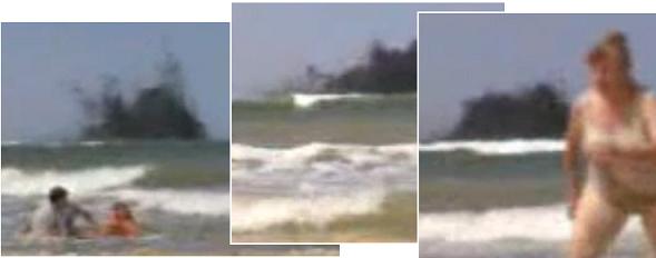
VIDEO: http://www.youtube.com/watch?v=O9FvpPHk3tI
Saltwater Intrusion
A key point of observation to demonstrate the steady sinking of India and the Sunda Plate is "saltwater intrusion" or similar
phrases. Rain can cause rivers to overflow, as can the backwash from the sea preventing river water from draining, but
nothing says "sinking" more than saltwater intrusion. The 7 of 10 scenarios of the sinking of the Sunda Plate and the folding of
the Philippine and Mariana plates has still not completed, but sinking is steadily occurring as these recent articles highlight.
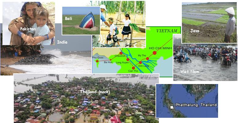
- India: Ominous Sea Pushes Coastal Villagers to the Edge
September 3, 2011
http://ibnlive.in.com/news/ominous-sea-pushes-coastal-villagers
- Just 100 metres from the sea, they dread the hungry tidal waves. Around 200 people belonging to 35 families
in the village are living in the fear of losing their home and hearth as the waves have already breached at
several places and uprooted thousands of casuarina plants to enter the coastal villages. Besides Chandrabali,
the waves also threaten Gambharia, Kumbhargadi, Narayanmahantipadia, Sahapur, Udaypur and Talasari in
Bhogarai block, nearly a lakh people in about 50 villages in Jaleswar, Baliapal, Remuna, Sadar, Soro and
Bahanga blocks of Balasore district and Basudevpur and Chandabali blocks of Bhadrak district.
-
- Philippines: Landslide Kills 2 in Olongapo City
August 30, 2011
http://newsinfo.inquirer.net/50515/landslide-kills-2-in-olongapo-city
- High tide worsened the flooding in the city, with water from the Lingayen Gulf entering the city's business
district. Flooded villages include Malued, Bacayao Norte, Bacayao Sur, Lasip Grande, Lasip Chico, Lucao,
Pogo Grande, Herrero-Perez, Manguin, Salisay, Pantal and Mamalingling.
-
- Bali: Is Your Hotel Sinking?
September 2, 1011
http://www.balidiscovery.com/messages/message.asp?Id=7365
- Saltwater Intrusion Threatens to Undermine Hotels on Bali's Beachfronts. Saltwater intrusion is now estimated
to have penetrated to a distance of 20-25 meters inland in some areas along Bali's coastline.
-
- Java: Rob Flood Flood the Agricultural Land Belongs to Citizens
September 3, 2011
http://jateng.tribunnews.com/2011/09/03/banjir-rob-genangi-lahan
- About ten hectare agricultural land in the Village area Banaran, District strain brackish water submerged due
to flooding of sea water rob Trisik Beach. As a result, rice and corn crops on the land is threatened to death.
-
- Pakistan: WPC Donates Relief Goods for Flood Affectees
August 31, 2011
http://pakobserver.net/detailnews.asp?id=112052
- The heavy downpour of August 10 resulted in floods and sea water intrusions in some parts of Sindh. Badin
being the worst hit area amongst these was merged under water and some 1.8 million people had been forced
to leave their homes, lands and belongings to take refuge in relief camps.
-
- Vietnam: High tide to Cross Danger Levels in City
August 30, 2011
http://www.saigon-gpdaily.com.vn/Hochiminhcity/2011/8/96267/
- High tide waters are already beginning to surge in the lower sections of the Sai Gon-Dong Nai River.
-
- Vietnam: Raging Floods in the South
August 28, 2011
http://www.cuuchienbinh.com.vn/PrintPreview.aspx?ID=10011
- The pearl island, Phu Quoc (Kien Giang) submerged in water. Near the junction of the communal farm near
Ocean water was waist to 4 km along the route.
-
- Thailand: Millions of People Isolated Because of Flooding
Setember 5, 2011
http://tintuc.xalo.vn/00-26897933/Thai_Lan_Hang_trieu_nguoi
- According to the Office of Disaster Affairs Ministry of Thailand, the 63 districts of the southern provinces into
serious flooding, namely Nakhon Si Thammarat, Surat Thani, Chumphon, Phang Nga, Ranong , Trang, Krabi
and Phatthalung.
-
- Thailand: Rakam Serious Flooding was Still a Crisis.
September 5, 2011
http://news.impaqmsn.com/articles.aspx?id=445449&ch=lc1
- Rice fields and crops are submerged for more than a month.
Swift Moon
The Earth wobble caused by the near presence of Planet X has been noted by the general public in many ways. The weather
has suddenly changed, and changed direction, satellite maps showing this change in direction of the prevailing winds, as noted
on July 31, 2011 in Issue 252 of this newsletter when the satellite views showed the wind from the northwest, then suddenly
switching to be from the southwest. The weatherman and NOAA are silent about this switching about. The figure 8 of the
Earth wobble also puts the Sun in the wrong position, most notably at sunrise and sunset. NASA is silent about this most
obvious piece of evidence that Planet X is in the vicinity.
ZetaTalk Explanation 2/5/2011: As has been present since the wobble ensued in 2004, the Earth wobble takes the
form of a figure 8. This causes the N Pole of Earth to lean to one side or the other during the figure 8, and also to
lean toward and away from the Sun during the figure 8. Depending upon where the globe is being pushed, or how
much Sun it is getting, or how violent the push is at this or that point, the land underneath will experience weather
extremes.
The violent pushing back and forth, the Earth wobble, also produced high tides which have no official explanation. The
weathermen can only shrug, as they have long been silenced.
ZetaTalk Comment 6/18/2011: The wobble has and will create high tides that the authorities cannot blame on
tsunami associated with earthquakes nor on the Moon. These tides are of record now, in accordance with our
predictions.
The wobble is at the heart of the increase in earthquakes, as jerking the globe around creates plate movement, and the more
violent the wobble, the greater the plate movement. There is in fact a relationship between the magnetic push and pull on the
Earth that Planet X exerts and the more frequent and violent earthquakes the Earth has been enduring. This relationship was
noted in a Pole Shift ning blog, tracking the relationship of the magnetic contortions evident on the magnetic simulator and
earthquakes from the jerking around the Earth does to evade the hose of magnetic particles coming from Planet X. The
USGS continues to downgrade quake magnitudes and remains mum about the presence of Planet X in the vicinity.
ZetaTalk Explanation 10/9/2010: What causes plates to break their hold on one another, along their borders, so they
can move. What incites the movement in the first place? We have described the increasing earthquake magnitude
and frequency during the Earth wobble, in place since 2004.
ZetaTalk Explanation 11/13/2010: The dance between Planet X and the Earth is magnetic and thus subject to sudden
switching about. If you toy with magnets on a glass plate, moving a powerful magnet under them in various
directions and from various angles, you will find sudden jerks into different postures. This is what the Earth is trying
to do.
But the wobble effect most noticed and hardest for the establishment to explain is the sudden movement of the Moon, which
has recently come of note as the wobble has recently become more violent. The GodLikeProduction message board,
normally awash with paid disinformation agents who ridicule any mention of the Earth changes or the ZetaTalk website,
recently hosted a discussion which could not be silenced. The Moon was moving swiftly across the skies.
Why and how the hell is the moon moving so fast? A couple of minutes ago it was up in the sky and
now it disappeared in the horizon. It was incredibly fast! I saw it in the sky at night and a couple of
minutes later, less than 10 minutes, it was already disappearing in the horizon. It was moving
extremely fast. I've never seen something like this happening. [and from another] I have also noticed
that it moves really fast lately. Noticed this probably a couple / few months ago. [and from another]
Even the dark spots on the moon rotate. I was leaning on a wall the other night, not moving. Seen the
moon peeking out behind a pole, within minutes, I watched it move into clear sight and 1/8th way
across the sky. [and from another] Was out about 9 pm and the moon was moving fast. About an hour
earlier I was picking apples and the moon was high, yet not anywhere near the zenith, and then I
approached a minute later to get a better view it had become hidden behind the trees in just a
moment of time. The Sun has been moving strangely as well, taking a low orbit and traveling closer
to the horizon line as well as setting further North than normal. [and from another] I've noticed that
the Sun is moving differently too, but I wasn't sure about it. [and from another] A few weeks ago I was
at a friends house sitting in the backyard with him. I remember seeing the moon between two big
trees and slightly under a telephone pole wire that was in his backyard. The moon was a few feet
below this telephone pole cable/wire. Not even 5 minutes had passed by and the moon was above the
telephone cable/wire from my viewpoint, and kept rising higher and higher at a very fast rate. I have
never ever seen the moon move this fast in my life.
This was a sign mentioned in the Kolbrin, the Egyptian text recording previous passages of Planet X, aka Nibiru. Noah took
this as his sign to prepare his arc.
They had knowledge of signs and omens, the secrets of the seasons, of the moon and the coming of
the waters. There were wise men filled with the inner wisdom, who read The Book of Heaven with
understanding and knew the signs. Then the day came when The Lady of the Night changed her
garment for one of a different hue, and her form swept more swiftly across the skies. Her tresses
streamed out behind in gold and copper, and she rode in a chariot of fire.
And how do the Zetas anticipate that NASA, the main liar in the Planet X cover-up, will react? They will run and hide.
ZetaTalk Prediction 8/14/2011: As long as control of the media can be maintained, NASA will keep on with the same
ridiculous cover stories. They will keep up with the stories until the day that a wobble proves that a body is nearby,
causing the Earth to totter. Then the doors will be shut, the phones not answered, and they will have fled to their
bunkers.
Sure enough, NASA's latest attempt to explain the wobble weather, and the sinking of plates in Asia causing horrific flooding,
is to publicize a fancy scientific term! If you question their pronouncements, its because you're not part of the NASA elite,
and don't have a brain that can think. You're not educated! It's all caused by the Rossby waves, don't you know? Perhaps
the Rossby waves are blowing the Moon about too.
- Same Abnormal Atmospheric Wave Responsible for Heatwave and Rains
September 2, 2011
http://www.dailymail.co.uk/sciencetech/article-2033029/
- Two of the most extreme natural disasters of 2010 were caused by the same weather event even though they
took place more than 1,500 miles apart, claims a NASA study. The heatwave and lethal wildfires of Russia and
the punishing floods in Pakistan were caused by abnormal behaviour in an atmospheric wave in August 2010.
But quite what caused this fluctuation to deviate so far from the norm remains unknown. The Russian event
produced the hottest summer in the country's history, causing roughly $15 billion in damages and killing an
estimated 56,000 people in more than 300 wildfires. The Pakistan flood submerged one-fifth of the country's
total land mass - approximately 307,374 square miles - and had a death toll of around 2,000, though it directly
affected 20 million people with the destruction of property. The atmospheric wave responsible, which is called
a Rossby Wave, is caused when the fast-flowing jet stream air currents in the atmosphere wander from their
usual course. The latest NASA research now says that it was an abnormal Rossby Wave which was responsible
for both natural disasters. The discovery was made by analysing data from Merra - the Modern Era
Retrospective-analysis for Research and Applications - NASA's instrument to measure the surface temperature
of land, as well as the intensity of rain and any wildfire activity.
You received this Newsletter because you subscribed to the ZetaTalk Newsletter service. If undesired, you can quickly Unsubscribe.
|