Java
Cockpit View
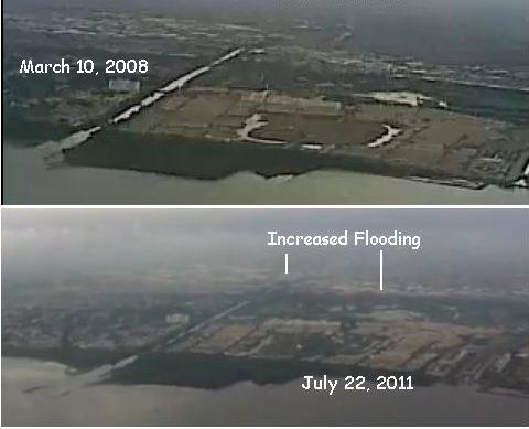
How much sinking has occurred in Java since December, 2010 as
the Zetas predicted? Videos taken from airplanes taking off and
landing in Jakarta and Semarang (both on the north Java
coastline) show definitively that there has been sinking! Where
the Indonesian government might suppress reporting in the press,
insisting the de rigor mention of rain and subsidence due to
ground water extraction always be included, these videos taken
by private individuals have not been suppressed. These are
apples to apples comparison shots taken in 2008 and 2011 posted.
These videos were just waiting to be discovered as was noted by
a hard working Pole
Shift ning researcher.
VIDEO: March 10, 2008 http://www.youtube.com/watch?v=b7soiZl_wJY
VIDEO: July 22, 2011 http://www.youtube.com/watch?v=lMf3e0MSWI0
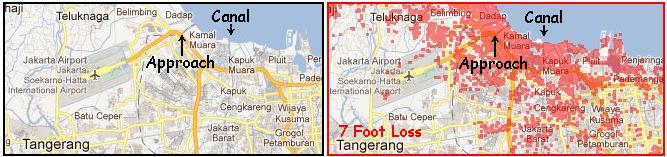
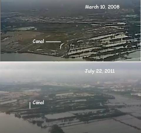
There are two views where landmarks allow a direct comparison.
The first is where a straight canal empties into the sea. Here
there is a portion of land that would not be under water with a
loss of 7 foot, but there is also flooding around this
point, showing that such sinking has occurred since 2008.
The second view is below the plane as it makes a perpendicular
turn to descend. This is over land that would be under
water with a loss of 7 feet in elevation. A twisting canal can
be seen in both videos, the view taken looking to the east as
the plane descends to the landing strip.
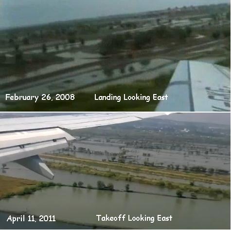
Semarang, to the east of Jakarta on the north coast of Java,
also shows sinking in comparisons between 2008 and 2011.
VIDEO: February 26, 2008 http://www.youtube.com/watch?v=9r1GdMB9SUk
VIDEO: April 11, 2011 http://www.youtube.com/watch?v=lcbuOagY_UM
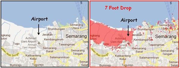
Sinking can be seen when comparing views to the east as a plane
lands or takes off.
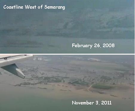
The coastline to the west of Semarang does not have the flooding
in 2008 that can be seen in 2011. As with Jakarta, this is
apparent when compared to a map showing a 7 foot drop in
elevation. Jakarta and Semarang are predicted, by the Zetas, to
lose 80 feet when the 7 of 10 sinking of the Sunda Plate
completes. As of April and July, 2011 it clearly had a long way
to go. Nevertheless, views from the airplane windows provide
irrefutable proof of sinking!
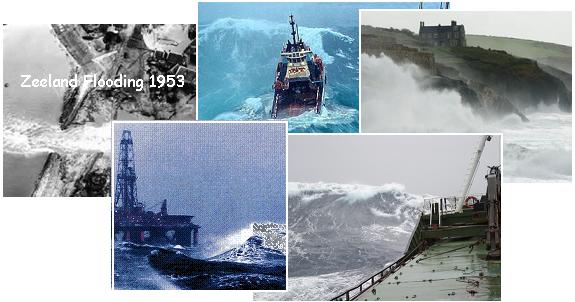
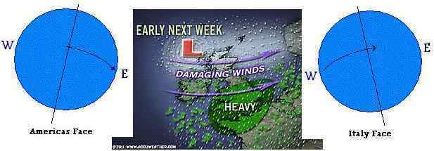
North Sea Hurricanes
The coastlines of the UK have been battered recently by North
Sea hurricanes, though this is nothing unusual. What is unusual
is the pace, which seems to be picking up and unrelenting. It's
clear from reports elsewhere around the world that the wobble
has picked up, the globe flinging back and forth violently on a
daily basis.
ZetaTalk Explanation
1/20/2007: For Europe, which is tipped to
the left, the north-west, during the wobble, and then back
again to the right, to the north-east, the wobble acts like a
pump, first pushing air down toward the Equator and then
sucking it back up. Combined with the Coriolis effect, this
creates swirls, drawing the cold air from the Arctic down into
the center, thus the hurricane formation.

- Scotland Shut Down By Icy 165mph
Blasts
December 8, 2011
http://news.sky.com/home/uk-news/article/16125967
- A fierce storm with winds of up to
165mph has battered northern parts of Britain, with people
warned to stay indoors, schools forced to close and
flights and rail links cancelled.
-
- String of Storm Systems Equivalent to
a Category Four Hurricane to Strike UK
December 11, 2011
http://www.theweatherspace.com/news/TWS-121111-uk
- A storm system last week produced
very damaging winds across the area and if you can believe
it or not, a string of storms stronger than the last one
will smack the area this next week. The storm pattern is
very dangerous this next week across the United Kingdom as
storm systems approach the area from the west. These storm
systems have central surface low pressure readings that of
major hurricanes, including one by the end of the week
being equivalent to a category four hurricane.
-
- Waves in Dublin Bay as High Winds
Swept Across the Country
December 14, 2011
http://uk.news.yahoo.com/monster-wave-hits-irish-shores-191149204.html
- The biggest wave ever to hit Irish
shores has been recorded. The monster 67-footer was
measured at a special buoy off the Donegal coast as a
force 10 storm raged across the north coast.
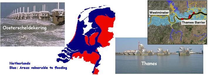
Will Europe's lowlands suffer from inundation prior to the 7 of
10 European tsunami? Denmark, the Netherlands, and the lowlands
of Germany are vulnerable. London has a storm surge door at the
Thames River, and the Netherlands likewise closes their rivers
with storm surge doors, such as the Oosterscheldekering, which
are only closed during storms. But per the Zetas, such lowlands
in Europe will begin to be evacuated before the 7 of 10 European
tsunami.
ZetaTalk Prediction
12/17/2011: Will this mean continuous
hurricane activity along the European coast? This will be the
minor effect, as with an increased wobble the storm surge will
likewise increase, sending unprecedented high tides into the
lowlands of Europe. Well before the 7 of 10 European tsunami
Europe will be faced with having to evacuate vulnerable
lowlands. The UK obviously takes the brunt of these storms, as
has Norway, but it is where the elevation will drive the storm
surge over the sea walls that evacuation will begin. London is
vulnerable. The Netherlands and Denmark are very vulnerable.
Civil defense exercises by emergency teams to evacuate and
rescue people when the surge is in process are only the first
step. It is clear that many countries within Europe intend to partner with
each other during such a crisis, sending in rescue teams
with boats and choppers. But what then? If the lowlands have
become unlivable, what then? Cooperation within Europe will be
challenged, as no one wants refugees. The welcome that many
immigrants have received in the past, when the economy supported
job growth, will be withdrawn, often suddenly and rather
brutally. If the debt carried by Italy and Greece have become a
headache for the European Union, just imagine what drowning
refugees from many member countries will entail!
IRIS 7 of 10
Revelation
The USGS Incorporated Research Institutions Seismology site, known as IRIS, shows
at a glance where earthquakes have occurred as well as the most
recent quakes over magnitude 4. This newsletter frequently makes
use of IRIS charts to show where plate movement has been
occurring. But more has been revealed. The IRIS charts also show
quakes over the past 5 years with little purple dots, which
cluster along plate borders and fault lines. A ZetaTalk fan has
noted that the frequency of quakes has dramatically increased!
This increase in quake frequency was noted and mentioned on
August 14, 2011 in Issue
254 of this newsletter and a year earlier in August 15,
2010 in Issue 198 of
this newsletter.
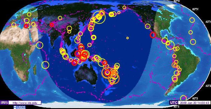
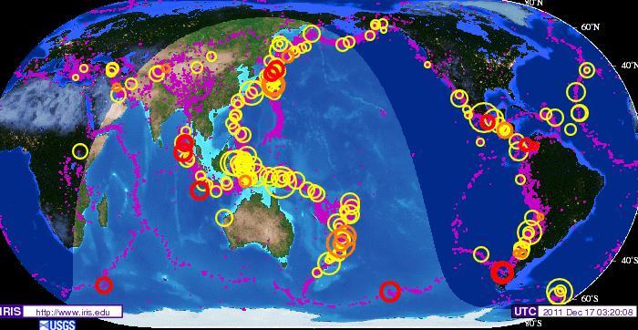
Compare the historical 5-year chart showing all quakes from
January 20, 2004 to January 20, 2009 to a chart showing the two
years since. Clearly the pace has picked up. In particular, the
plate edges involved in the early 7 of 10 scenarios show this
dramatic increase. If one could peer beneath the outline of the
Sunda Plate and the eastern border of the Indo-Australian Plate,
they are fat with purple quake dots as is the region above India
in the Himalayas. The Philippine Plate is heavily outlined. The
Andes are fat with dots. And the eastern border of the Caribbean
Plate is likewise thick with dots. Compared to the West Coast of
the US, the borders of the African Plate, and the Atlantic Ridge
borders, it is obvious the increased quakes are due to the 7 of
10 plate movements.
ZetaTalk Prediction
10/16/2010: The sequence of events is,
thus a tipping Indo-Australia Plate with Indonesia sinking, a
folding Pacific allowing S America to roll, a tearing of the
south Atlantic Rift allowing Africa to roll and the floor of
the Mediterranean to drop.
Fracking Earthquake
Excuses
Desperate to explain the increase in earthquakes, the
establishment is reaching, these days. One excuse is to claim
that fracking, a technique used to open rock pockets to extract
oil or gas, causes earthquakes. Fracking has been in use since
1903 in the US, but this claim that it causes quakes has only
been made since 2009.
- Hydraulic Fracturing
http://en.wikipedia.org/wiki/Hydraulic_fracturing
- A report in the UK concluded that
fracking was the likely cause of some small earth tremors
that happened during shale gas drilling.[50][51] In
addition the United States Geological Survey (USGS)
reports that "Earthquakes induced by human activity have
been documented in a few locations" in the United States,
Japan, and Canada; "the cause was injection of fluids into
deep wells for waste disposal and secondary recovery of
oil, and the use of reservoirs for water supplies."[52]
[50] http://www.bbc.co.uk/news/uk-england-lancashire-15550458
Fracking tests near Blackpool 'likely cause' of tremors.
November 11, 2011.
[52] http://earthquake.usgs.gov/learn/faq/?categoryID=1&faqID=1Q
"FAQs - Earthquakes, Faults, Plate Tectonics, Earth
Structure: Can we cause earthquakes? Is there any way to
prevent earthquakes?" USGS. October 27, 2009.
Clearly a recently invented excuse. The New Madrid Fault line
runs through Ohio, and the spreading Seaway is causing
sinkholes, but the increase in earthquakes is now being blamed
on fracking. And in Iceland, where the spreading Atlantic Rift
is tearing Iceland apart, quakes are now being blamed on
fracking.
- Add Quakes to Rumblings Over Gas Rush
December 12, 2011
http://www.nytimes.com/2011/12/13/science/some-blame-hydraulic
- Nine quakes in eight months in a
seismically inactive area is unusual. But Ohio
seismologists found another surprise when they plotted the
quakes' epicenters: most coincided with the location of a
9,000-foot well in an industrial lot along the Mahoning
River, just two miles from downtown Youngstown. Scientists
say the likelihood of that link is extremely remote, that
thousands of fracking and disposal wells operate
nationwide without causing earthquakes, and that the
relatively shallow depths of these wells mean that any
earthquakes that are triggered would be minor.
-
- Short Note on Hengill Volcano Man-Made
Earthquake Swarm
October 17, 2011
http://www.jonfr.com/volcano/?p=1655
- The earthquake swarms that have
been taking place in Hengill volcano are man made due to
Orkuveita Reykjavíkur pumping down water at the depth of
2500 meters or more. They have been doing this for some
time now. But when they started using new drilling holes
to pump down water the earthquake swarms started to
happen.
Per the Zetas earthquakes cannot be caused by fracking, which
does not have the scope required to trigger a quake.
ZetaTalk Prediction
12/17/2011: Where it is known that mining
accidents, explosions, can cause buildings in the vicinity to
shake and windows to rattle, such activity on the surface does
not cause earthquakes. Earthquakes are caused by an adjustment
in the entire rock strata, over a wide and deep area. The
epicenter is merely the point where the adjustment, or
movement, is greatest. The pressure that caused that
adjustment spreads for hundreds of miles, in all directions.
Fracking cannot accomplish this.
The establishment has proffered silly excuses before. In 2003
twice daily shuddering, the global quakes, showed up on the live
seismographs at 1:00 UTC and 12:00 UTC. As for an explanation,
the USGS first claimed this was caused by nearby thunderstorms and then by nearby traffic. The establishment is again
reaching into the land of the ridiculous. Had rain anytime in
the last few months? That explains your recent earthquake! Into
the land of the loopy we go.
- Heavy Rainfall Can Cause Huge
Earthquakes
December 15, 2011
http://news.nationalgeographic.com/news/2011/11/111215-rainfall
- Rain-induced erosion loosens
faults, scientist says. Shimon Wdowinski, of the
University of Miami in Florida, first noticed a connection
between storms and earthquakes last year. The devastating
magnitude 7.0 earthquake that hit Haiti in early 2010 came
only 18 months after Haiti had been deluged by several
hurricanes and tropical storms. And another large
earthquake, a magnitude 6.4 temblor that rocked Taiwan in
2009, occurred only seven months after the area had been
hit by Typhoon Morakot, which dropped 9.5 feet (2.9
meters) of rain in five days.
You received this Newsletter because you subscribed to the ZetaTalk
Newsletter service. If undesired, you can quickly Unsubscribe.
|