Mariana Trench Collapse
Is the trench collapsing? Certainly buoys 52402 and 52403 are are signaling that. The Philippine Plate lies to the east of the
Philippine Islands, and the Mariana Plate lies to the east of the Mariana Islands, and the Mariana Trench lies to the east of the
Mariana Plate.

- Mariana Trench
http://en.wikipedia.org/wiki/Mariana_Trench
- The Mariana Trench or Marianas Trench is the deepest part of the world's oceans. It is located in the western
Pacific Ocean, to the east of the Mariana Islands.
The Zetas predicted that the folding of the Mariana Trench would be sudden. The Zetas also stated that the folding of the
Philippine and Mariana plates in 7 of 10 Scenario 3 is key to acceleration of the 7 of 10 scenarios.
ZetaTalk Prediction 11/27/2010: The folding of the Pacific plates that accompany the sinking of Indonesia during the
7 of 10 scenarios involves, as we have explained, the Mariana and Philippine plates tilting and flattening westward.
The Mariana Trench is a zone where the Pacific Plate is subducting under the Mariana Plate. The Pacific Plate
curves down at this point, plunging under the Mariana Islands which ride on the Mariana Plate. The trench will be
suddenly closed, so that rather than a trench there will be the Pacific Plate scraping along the Mariana Plate.
ZetaTalk Prediction 9/17/2011: We have stated that the Sunda Plate will complete its sinking by the time the S
American roll is at its peak, but not before. The folding of the Philippine and Mariana plates also must be almost
complete before the S American roll can accelerate. Number 3 is likely to complete hand-in-hand with number 2
rather suddenly at a time when the Indo-Australia Plate lifts and plunges under the Himalayas.
Buoy 52402 shows that something dramatic occurred on December 13, 2011. Buoy 52402 is at Latitude 11.74N Longitude
154E out in the Pacific, just east of the trench and approximately 1/3 of the way to Hawaii from the Philippine Islands. What
would cause this buoy to show a sudden drop of 15 meters (45 feet) on December 13!

A clue lies in the heaping waters shown by Buoy 52403, which lies along the trench to the SW of 52402. Water squirting out
of a collapsing trench would end up in this vicinity, and it did! The waters on the Carolina Platelet are also not as deep as the
deep Pacific, and would take more time to disburse a heap, thus. Per the Zetas, the trench did indeed collapse on December
13.

ZetaTalk Comment 12/31/2011: When the trench collapses, the Pacific Plate suddenly takes a sharper angle when
subducting under the Mariana Plate, pushing the Mariana Plate to accelerate its tilt and fold, which then accelerates
the Philippine Plate's tilt and fold. At the point of collapse there is suddenly more water just above the trench,
moving in all directions. But such an adjustment is seldom smooth. Waves themselves have heaps and troughs as
there is a tendency for water to move as a mass, cohesive. When the trench collapsed, it created a heap, but for buoy
52402 there was a trough reaction, the 15 meter drop on December 13, 2011. The water also moved south, along the
deep trench, like along a funnel.
The Mariana Islands, on the lifting eastern edge of the Philippine Plate just to the west of the Mariana Plate, have been beset
with quakes since, even during lulls affecting the rest of the world.

03-JAN-2012  5.2	SOUTH OF MARIANA ISLANDS
01-JAN-2012  5.1	SOUTH OF MARIANA ISLANDS
01-JAN-2012  5.2	SOUTH OF MARIANA ISLANDS
30-DEC-2011  4.6	SOUTH OF MARIANA ISLANDS
16-DEC-2011  4.3	MARIANA ISLANDS REGION
Have the heaping waters been noted by those nearby, on the Philippine Islands? Certainly the Mindanao tsunami on
December 17 was caused by the disbursing waters. And just a quick end of the year snapshot for incidents in the Philippine
Islands show continuing references to capsizing boats, "swelling seawater", and a "storm surge" without an accompanying
storm.
- Waves Destroy 26 Houses in Aklan
December 28, 2011
http://www.philstar.com/nation/article.aspx?publicationSubCategoryId=200
- Apart from the damaged houses, several commercial establishments have been affected by the swelling
seawater. Residents were obliged to put up piles of sandbags along the coastlines.
-
- 12 Saved as Boat Capsizes off Cebu
December 3,1 2011
http://www.philstar.com/nation/article.aspx?publicationSubCategoryId=67
- Twelve people were rescued after their motorized boat capsized off Lapu-Lapu City in Cebu.
-
- State of Calamity Declared in Parts of Leyte, Cebu
December 31, 2011
http://www.philstar.com/nation/article.aspx?publicationSubCategoryId=67
- The low pressure area caused 14 flooding incidents, four landslides, three sea mishaps, and a storm surge, and
damaged a seawall.

7 of 10 Year in Review
7 of 10 Scenario 1, the tilting of India to put the Indus Valley in Pakistan at a 10 foot elevation loss occurred the latter half of
2010, as was acknowledged by NASA by the end of 2010.
ZetaTalk Prediction 10/16/2010: We have predicted that the western edge of India will only lose 10 feet of elevation
during the 7 of 10, and given the degree of flooding that Pakistan is already experiencing, Karachi has already
experienced some of this elevation loss. The flooding in Pakistan, however, is afflicting the Indus River valley to the
east of Karachi at this time, on that portion of Pakistan lying on the plate holding India.
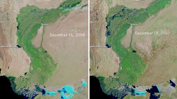
7 of 10 Scenario 2, the sinking of the Sunda Plate has progressed only half way, as of the end of 2011. These photos
discovered by a keen eyed Pole Shift ning member tell the tale. These photos are from the Modis website which provides
dated NASA satellites. For Java, it is notable that where the area near the city of Jakarta has been remarkably spared, other
parts of the north coast of Java appear to be at a 40 foot elevation loss. Some inland areas of Java also appear to be
flooded, not draining. An 80 foot elevation drop is predicted by the Zetas when sinking has completed, and some parts of
Java appear to be at that point already.

Manila has clearly sunk north of the bay and to the southeast of Manila, as predicted, and seems to be at the 40 foot loss
predicted by the Zetas as of the end of 2011. Bangkok has not recovered from its floods, nor will it, despite the claims that
this was only river drainage. Here again the flooding from sinking seems to equate to the 40 foot mark predicted by the
Zetas.

The island of Borneo is expected to suffer an 80 foot drop, but seems to only again be at the half way mark. But the tip of
Viet Nam appears to be devastated, closer to its predicted 40 foot drop with the loss of sea level reaching inland to
Cambodia.

7 of 10 Scenario 3, the folding of the Philippine and Mariana plates, is likewise still completing. The pace of this scenario
could be detected by reports of sinking from the north Philippine island of Luzon, which lies partially on the Philippine Plate.
When typhoon Falcon passed through in July, 2011 northern Luzon was entirely spared the flooding that the portion lying on
the Sunda Plate experienced. But by August 28, 2011 when typhoon Mina passed through, the northern coast of Luzon was
affected with flooding. The Mindanao tsunami on December 17, 2011 striking the Philippines was likewise, per the Zetas,
caused by a clash with waters from the folding Philippine Plate. Now, with the obvious collapse of the Mariana Trench, the
folding is clearly and undeniably in process.
7 of 10 Scenario 4, the S American roll, has clearly started but has not reached the point of the large quakes along the Andes
predicted by the Zetas. Nevertheless, crumbling in the North Andes, the press of the Caribbean Plate moving westward on
Guatemala and sinking on the southern Caribbean islands of Trinidad and Tobago have been evident all year.
ZetaTalk Prediction 2/26/2011: The S American roll will not take place in an instant, from start to end, as is obvious
from the preliminary movement already taking place. The region of the N Andes fault line is suffering mountain
building. The Caribbean Plate off coast from Colombia recorded sinking in 2010, and Panama is flooding due to
preliminary sinking, even having to close its locks at one point for the first time in its 125 year history due,
supposedly, to rain.
7 of 10 Scenario 5, the African Roll, is also showing signs of having started, though has barely begun.
Africa Roll Prelim
There are many clues that Africa has begun her roll. A major Internet cable, SMW3, torn in the Mediterranean and east of
India on December 19, 2011, shows this tear was related to plate movement. As noted in a Pole Shift ning blog, Internet
cable disruption has happened before, in 2008.
ZetaTalk Explanation 2/2/2008: As we have stated, the Arabian plate will rotate as this region of the world is pulled
apart. As though the "boot" were walking, it will move from where the "heel" appears to be landing to where the
"boot" is rolling to be positioned on its "toe". Where this does not put tension along a cable laid around the edges of
the "boot", it puts tension on the cable from another end - the landfall in India and Pakistan. The "heel" of the boot
has been pulled away from India and Pakistan. Overall, the stretch zones around the Arabian Plate are pulling open,
thus there is less slack on any cables laid there.
This time the story is similar, with torn cables in multiple places. This indicates major plate movement on more than one plate!

- Cable Cuts Could Slow Emirates Internet
December 26, 2011
http://en-maktoob.news.yahoo.com/company-cable-cuts-could-slow
- An Emirati phone company is warning customers they could face slower Internet connections after two
underwater communications cables were cut. The cuts happened on the SMW3 cable near Suez, Egypt, and on
the i2i cable, which links southern India and Singapore.
-
- Severed Cable Disrupts Net Access
December 19, 2011
http://news.bbc.co.uk/2/hi/technology/7792688.stm
- It is thought the FLAG FEA, SMW4, and SMW3 lines, near the Alexandria cable station in Egypt, have all
been cut. The main damage is to the four submarine cables running across the Mediterranean and through the
Suez Canal.
And quakes are happening along the plate borders. As the Indo-Australian Plate lifts and plunges under the Himalayas and
the Atlantic Rift pulls open, Africa rolls, the boot of the Arabian Plate turns in place, and Internet cables all along this line are
ripped from their coastal moorings.
2011-12-23 5.1 PAKISTAN
2011-12-25 4.6 IRAN-IRAQ BORDER REGION
2011-12-26 4.6 CARLSBERG RIDGE
2011-12-25 4.3 ETHIOPIA
This tale is told in the buoys too. As the eastern end of the Indo-Australian Plate rises, the buoy in the Coral Sea east of
Australia reports the sea is more shallow. Likewise, as the India portion of the plate is pushed down, a buoy in the Arabian
Sea finds sudden great fluctuations, as the dedicated crew at the Pole Shift ning have recorded. For the water dept to range
up to 30 meters (90 feet) outside of its normal range, suddenly, certainly indicates rising and lowering sea levels, with the
water temporarily heaping or suffering a void.


African stretch zones also tell this tale. Recently a building in Lagos, Nigeria suddenly collapsed, a clear sign of a stretch zone
accident as reported in Issue 271 of this newsletter. As Africa rolls, the top and bottom part of the continent are tugged in
different directions, pulling the continent apart somewhat at Nigeria. Hold the top part of Africa firmly in your left hand, and
grasp and pull the bottom part toward the east with your right hand, and you can sense what is happening there, at Nigeria.
Now an oil spill has resulted, on December 21, 2011 from this same stretch.
- Worst Offshore Oil Spill for Over 10 Years in Nigeria
December 25, 2011
http://www.nzherald.co.nz/environment/news/article.cfm?c_id=39
- A London-based spokesman for Shell declined to comment on specifics about the spill, saying a company is
still investigating the cause. The company did release an underwater image of the 48-centimetre pipeline that
caused the leak, which showed a rupture along it.

And further to the east, in the heart of the African Rift Valley, The course of rivers and expected drainage is changed due to
the stretch. Suddenly, lowlands are lower still, river bottoms increase in scope, and the people are drowning.

- Flooding in Tanzania
Dec. 21, 2011
http://www.chron.com/news/nation-world/world/gallery/Flooding-in-Tanzania
- According to an official at least 8 people are reportedly killed and many others are missing after the city Dar
Es Salaam was hit by the worst floods in decades for two consecutive days.
Per the Zetas, this is to be expected in a stretch zone. River drainage is impeded.
ZetaTalk Prediction 2001: As the African Rift Valley spreads apart, Lake Victoria will grow in size, as will the other
great lakes east of Victoria beyond the mountains to the west. Just as the rolling of the African Plate will widen the
Red Sea, as it has in the past, those parts of Africa that are tearing apart will increase their spread. Since Africa is
high land, this will not result in an invasion of seawater. Some elevation rise in the mountains along the tear should
be expected, as the plate can bounce up there, being released from the surface tension that existed prior to the rip.
You received this Newsletter because you subscribed to the ZetaTalk Newsletter service. If undesired, you can quickly Unsubscribe.
|