Sunda Sunk
The Zetas, and only the Zetas predicted the sinking on the Sunda Plate during the 7 of 10 plate movements. On October 16,
2010 they were very specific on what was going to happen to the lands lying on the Eurasian plate tongue lobbing down to
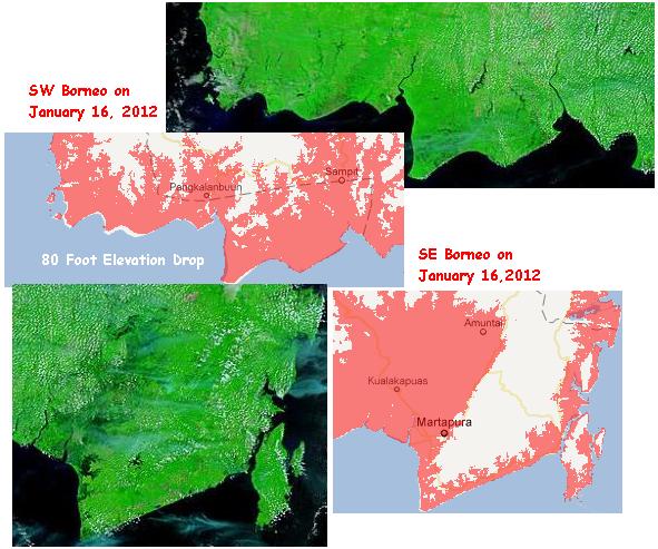
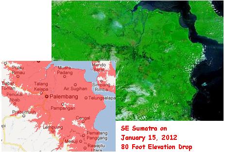
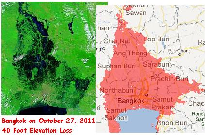
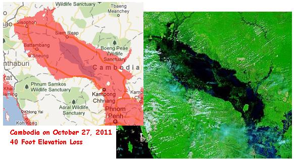
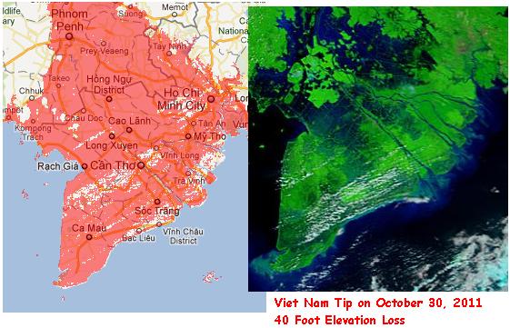
hold SE Asia, better known as the Sunda Plate region. The Zetas estimated a 20 foot elevation loss along the South China
coastline, 40 foot loss across Thailand to the Philippines, and an 80 foot loss for most of Sumatra, Java, and southern
Borneo. Remember, this is land that will be affected by flooding with the anticipated elevation loss, not necessarily land that
will become sea due to this loss. It may only become swampland, flooded without draining and needing seawalls to keep the
tide from inundating it.
ZetaTalk Prediction 10/16/2010: If the loss of 40 feet in elevation is not devastating to the Philippines, it is to the
coastline of southern Burma, Tailand, and Cambodia, which have vast areas that will suddenly and permanently be
flooded. It is the southern tip of the tongue which is utterly devastated. Draw a line just north of the Malaysia border
and over the top of Borneo. The land on the tongue from this point south will double its elevation loss, so that Java
and the islands bordering the Banda Sea will find they have lost a full 80 feet in elevation, sinking many coastal
cities and small islands out of sight. Singapore will be awash, its streets hopelessly inundated. Vast areas of the
northern coastline of Sumatra and the southern coastline of Borneo will likewise be inundated.
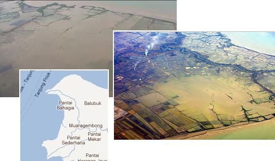
Has this occurred? Except for Singapore, this degree of sinking is absolutely apparent on the MODIS satellite images, and on
photos and videos taken by private individuals from airplanes. Compare the predicted sea level loss, made by the Zetas in
late 2010, to what can be seen on the MODIS images today. When compared to MODIS a year or more ago, one can
clearly see the flooding that has arrived, and remained! The red regions on the maps are showing areas that would be
affected if the predicted elevation loss were to occur.
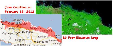
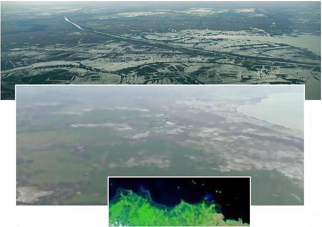
Jakarta in particular has recently sustained more sinking. A recent video from a plane leaving Jakarta airport confirms the
degree of flooding to the west of the airport, and along the coastline to the west. Photos available on flicker also confirm this.
Notice the degree of flooding inland! They use sea walls and pump out the residential areas extensively. But still North
Jakarta has been confirmed by the government to be 70% below sea level for some months now.
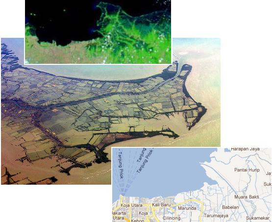
The peninsula just to the east of Jakarta also shows the extensive sinking. This peninsula has a drainage canal running parallel
to a snaking river. Further to the east is another peninsula also showing extensive flooding. This is not due to rainfall when the
entire coastline has become inundated and the inundated land is open to the sea and they are clearly at the same elevation, the
same level. This is sinking!
Sakurajima Erupts
This Japanese volcano is on a southern island, very much affected by the 7 of 10 plate movements ongoing. As noted in this
Pole Shift ning blog, Sakurajima's eruption history took a sharp increase since 2010.
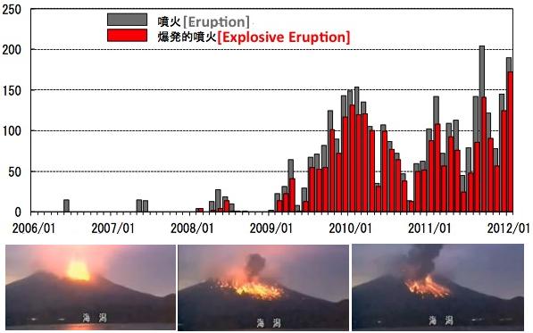
- Japan: Sakurajima Volcano Erupts Spewing Lava and Ash
February 19, 2012
http://theintelhub.com/2012/02/19/japan-sakurajima-volcano-erupts-spewing-lava-and-ash/
- Sakurajima volcano in southern Japan erupted Sunday with a few violent burps of gas and lava. Massive
bursts of light shined through the ash cloud as the eruption took place.
Note the location. As the Philippine Plate tilts and folds, it subducts sharply under the south islands of Japan. At Sakurajima's
precise location there is also a fracturing of the great Eurasian Plate. Sakurajima's eruption comes just after a period where
heaping water east of the Mariana Trench was evident, as shown by buoy 52402 in Issue 282 of this newsletter just last
week. The Mariana and Philippine plates are tilting and folding, and this likewise affects Sakurajima's location. Per the Zetas
the Philippine Plate normally applies less pressure to Japan than the Pacific Plate to the north, so this is clearly due to
movement in the Philippine Plate.
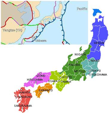
ZetaTalk Comment 10/15/2011: The South Island is attached to the very stable Eurasian Plate, and as can be seen
from a map of active volcanoes, has almost no volcanic activity when compared to the highly active volcanoes
throughout the North Island. Pressure on the South Island is relieved at the border with the Philippine Plate, which
tilts to relieve the pressure and does not push under the Eurasian Plate to the extent that subduction under the North
Island occurs.
Agulhas Whirlpool
In the Safe Locations documentation on S Africa the Zetas warn that tides and waves off the tip of S Africa will be fearsome
during the hour of the Pole Shift. Water will rush from the Indian Ocean to the South Atlantic, and back again.
ZetaTalk Prediction 1995: South Africa's largest problem will be during the shift itself, as it lies between the Atlantic
and Indian Ocean. During India's subduction, an actual suction will occur there, drawing water. When the Atlantic
widens, a similar situation will occur. During the week when rotation stops, the waters of the earth will drift toward
the poles, so during the shift will have a tendency to rush to fill the gaps in the Atlantic and Indian Oceans. Water on
the move is unpredictable and forceful, and South Africa will stick out into this maelstrom unprotected. Those
wanting to survive the shift should move well inland and return only after water sloshing has stopped, a period of
several days, to be safe.
The Agulhas Current, rushing past Cape Agulhas on the tip of S Africa, is considered the strongest in the world.
- Cape Agulhas
http://en.wikipedia.org/wiki/Cape_Agulhas
- It is the geographic southern tip of Africa and the official dividing point between the Atlantic and Indian
Oceans.
-
- Agulhas Current
http://en.wikipedia.org/wiki/Agulhas_Current
- It flows down the east coast of Africa from 27°S to 40°S. It is narrow, swift and strong.
Now a monstrous whirlpool has been discovered in the current, by all accounts stumping scientists who cannot figure out why
this has occurred. The whirlpool is 90 miles wide, and visible from satellites.
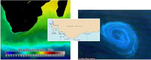
- An Unusually Strong Whirlpool Emerged near the Coast of South Africa
February 21, 2012
http://hainanwel.com/en/unusual-world/1546-whirlpool-south-africa.html
- The width of the whirlpool is 170 kilometers and it is located a few hundred meters below of the water surface.
Scientists can not explain the reason for pumping water from the Indian Ocean to the southern of Atlantic
Ocean, which led to the emergence of this whirlpool.
-
- Satellite Captures Enormous 90-Mile-Wide Storm that's Underwater
February 21, 2012
http://www.dailymail.co.uk/sciencetech/article-2104279/
- A NASA satellite has provided jaw-dropping pictures of a huge 'storm' brewing under the sea. The swirling
mass of water - which measures a whopping 93 miles wide - has been spotted off the coast of South Africa by
the Terra satellite on December 26. This counter-clockwise eddy is thought to have peeled off from the
Agulhas Current, which flows along the southeastern coast of Africa and around the tip of South Africa.
The Earth wobble, the Figure 8 that occurs daily due to the N Pole of Earth being pushed away by the N Pole of the
approaching Planet X, has created a similar situation for the tip of S Africa to that presented by the Zetas for the hour of the
shift. Per the Zetas, it is the Earth wobble pumping water from the Indian Ocean to the South Atlantic, and back again.
ZetaTalk Explanation 2/25/2012: The Figure 8 of the Earth wobble is causes the most extreme movements during the
circular swings at the poles of the Earth, and this certainly includes the region of S Africa. First the globe is forced
such that S Africa swings to the East, and then as the Figure 8 loop completes, to the West. What this does is
produce a pumping action, first increasing water pressure along the east coast, and then reversing this to produce
excess water pressure along the west coast. When strong enough, this could literally change the direction of the
Agulhas Current, but this point has not yet been reached.
The Agulhas Current normally flows from the Indian Ocean, which has relatively warmer water, to the South
Atlantic. When the water pressure in the Indian Ocean is increased by the wobble, this of course increases the
pressure of the flow, which would increase in force and speed. None of this in and of itself would produce a
whirlpool, however. It is the reverse wobble effect, when S Africa swings to push under the South Atlantic, that
produces the whirlpool. When this happens, there is a clash in the currents, and the Coriolis Effect as with all water
and air in motion on Earth clicks in and creates a whirlpool. The Earth wobble, and only the Earth wobble can
explain the Agulhas whirlpool.
Evidence of Aliens
A Zeta face has been discovered on an Egyptian tomb wall, and a suspected mummified "Zeta" among the human royalty, per
a Pole Shift ning blog. The "Zeta" has a distended belly and is more likely a Hydrocephalus, surgery attempted to correct the
problem. And all this time kept from the public eye by Egyptian officials who were cooperating with the cover-up over the
alien presence, presumably.
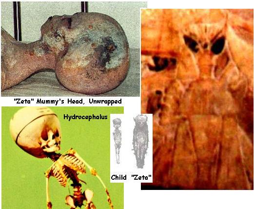
- ET Mummy Found In Egypt
February 23, 2012
http://www.pakalertpress.com/2012/02/23/et-mummy-found-in-egypt/?
- Buried in a dark corner of the Cairo Museum is a mummy that could change the world and our view of
humanity's place in the universe. Entombed thousands of years ago with the body of a Pharoah, the small,
frail-looking creature is easily recognizable to any present day UFO investigator: the body of an alien,
mummified Grey. Famous Egyptologists like the now deposed Antiquities Minister, Zahi Hawass, found
bizarre artifacts and disturbing tomb paintings and clamped down on the embarrassing finds with a tight lid of
security. Any leaks that emerged concerning the discoveries were met with denials, derision, and sometimes
veiled threats.
Then there is a new $20 Canadian coin, released in 2011! As noted on this YouTube video, there is an American Indian in a
canoe, and his reflection seems to be an odd looking bald child! Per the Zetas, someone in authority in the coin department is
hinting broadly that Canada would be a good home for the Hybrids in the Aftertime. On close inspection, the Hybrid can also
be seen as a child, looking directly down into the water, hair slicked back tightly along the head. But the discussion, and the
first take that this is an alien or Hybrid face, was viral on the Internet.
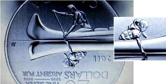
ZetaTalk Comment 2/25/2012: Why would a Canadian coin include a small creature with what appears to be a
deformed human face, the eyes too large for a human child and hairless? The coin is showing this at first glance as
the reflection, when assuming the lettering to be in the upright position. But upon closer examination, the American
Indian is the reflection, implying that Canada "reflects" its American Indian heritage. Is the apparent child just a
sloppy carving? The American Indian is precise, negating that excuse. This is intended to be a depiction of a hybrid,
hairless and with large eyes but the implication, the next residents of Canada! Or so Canada hopes, as the high tech
cities of the hybrids are much desired.
And more evidence of aliens on the Moon, in the past, courtesy of the Chinese government's Chang'e-2 moon orbiter. Per
the Zetas, China will not participate in the cover-up over the alien presence. They won't make pronouncements, but they
won't kill the evidence either.
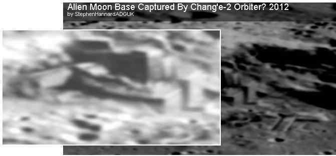
- Alien Moon Base Captured By Chang'e-2 Orbiter Video
February 20, 2012
http://scottcwaring.blogspot.com/2012/02/alien-moon-base-captured-by-change-2.html
- I was sent some pictures by a source who claims China will be releasing Hi Res images taken by the Chang'e-2
moon orbiter, which clearly show buildings and structures on the moons surface. He also claims NASA has
deliberately bombed important areas of the Moon in an effort to destroy ancient artefacts and facility's.
Pictures yet to be released clearly show nuclear impact craters and building debris caused by explosions in an
effort by NASA to destroy the truth. China is moving toward full disclosure of the Extraterrestrial reality, if
these images and future ones are verified genuine then NASA should be investigated for fraud and treason.
China will be releasing all the data and images from the Chang'e-2 in the coming weeks and months, lets hope
this is the beginning of a new era.
ZetaTalk Comment 2/25/2012: As we have frequently mentioned, the US is the country with the most to lose during
disclosure. They have since the days of Roswell been at the helm of the cover-up. They have dead alien bodies and
space ship junk to display, and thus could dispel the cover-up with a single press conference, but delay because so
many giant egos would have to explain that they lied these many years. Now comes China, with their own satellites
and their own Moon orbiter. China has constructed ghost cities openly, showing that they take the ZetaTalk message
seriously enough to construct cities for their elite to occupy after the Pole Shift. Where they are not making a public
statement on the reason for these ghost cities, they allow the world to come to its own conclusion. Their attitude
about alien artifacts will be similar. No cover-up. No admission, but no cover-up.
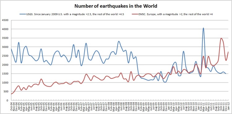
USGS Disclaimers
The USGS is in a pinch. Faced with increasing earthquakes, it was first ordered to under-report the magnitude and
frequency, and then ordered to take command of all earthquake reporting worldwide to give the appearance of a united front
during this subterfuge. As reported in Issue 2 of this newsletter on January 24, 2006, they were no longer free to simply
report their findings. They had to pass all this past the Bush administration. Apparently, arthquakes had become a national
security issue.
- Scientists Worried about Bush Clampdown at Publication
December 14, 2006
http://www.commondreams.org/headlines06/1214-01.htm
- The US administration is clamping down on scientists at the US Geological Survey. New rules require
screening of all facts and interpretations by agency scientists. The rules apply to all scientific papers and other
public documents, even minor reports or prepared talks, documents show. The changes amount to an overhaul
of commonly accepted procedures for all scientists, not just those in government, based on anonymous peer
reviews. In that process, scientists critique each other's findings to determine whether they deserve to be
published. From now on, USGS supervisors will demand to see the comments of outside peer reviewers' as
well any exchanges between the scientists who are seeking to publish their findings and the reviewers.
At that time, there seemed to be a delay in reporting. All sites had to wait until the USGS decided what they wanted to do
with a quake - drop, reduce, or allow. But during the December 26, 2004 great Sumatra quake of a magnitude 9.5, there
was disagreement on what magnitude applied. The USGS insisted the quake was a magnitude 8.9 or lower and finally
allowed the magnitude to creep up to 9.2, while local geologists called it a magnitude 9.5. This rule that a quake had to be
just below a statistically significant higher magnitude, a 5.9 instead of a magnitude 6.0 for instance, was detailed in Issue 245
of this newsletter on June 12, 2011. In this way statistics generated for magnitude 6 and above would not include the 5.9
quakes, and would appear to be less. Now yet another skew in reporting has taken place, as pointed out in a Pole Shift ning
blog. The USGS was forcing EMSC to be in step on quake reporting, but in 2009 seemed to separate. In addition, the
USGS is now deferring to NEIC, another quake collector. Anything, it seems, to blur the fact that quakes are not being
reported accurate. The USGS has thrown up their hands and run off to hide!
- ANSS/NEIC Combined Earthquake List
http://earthquake.usgs.gov/research/data/
- We maintain a catalog of earthquakes that merges the catalogs of the NEIC with those of the US Advanced
National Seismic System (ANSS) regional networks.
-
- Latest Earthquakes M5.0+ in the World - Past 7 days
http://earthquake.usgs.gov/earthquakes/recenteqsww/Quakes/quakes_big.php
- The maps and lists show events which have been located by the USGS and contributing agencies within the
last 7 days. They should not be considered to be complete lists of all events M2.5+ in the US and adjacent
areas and especially should not be considered to be complete lists of all events M4.5+ in the world. Beginning
January 1, 2009, earthquakes outside the US below M4.5 are not reported unless NEIC obtains felt reports.
The World Data Center for Seismology, Denver (a part of the USGS National Earthquake Information
Center) continues to receive data from observatories throughout the world for several months after the events
occurred, and using those data, adds new events and revises existing events in later publications.
You received this Newsletter because you subscribed to the ZetaTalk Newsletter service. If undesired, you can quickly Unsubscribe.
|