|
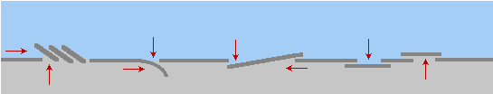
Rising and Sinking
Land
Land rises and falls during
the wrenching plate movements when Nibiru, aka Planet X, passes.
The Pole Shift causes a crustal shift, and per the Zetas it is a
scripted drama as to how the
plates adjust. During the forthcoming Pole Shift, India and the
western 2/3 of Australia are predicted to be plunged under the
waves, but new land will pop up between the tip of S America and
S Africa. This is in addition to Antarctic melting and becoming
habitable. The new land will be as a result of the Antarctic
Plate tilting.
ZetaTalk Prediction
2/15/1999: The
overlapping and compressing plates on the Pacific side
represent pressure and push. The separating and spreading
plates on the Atlantic side represent an opening, so the
Antarctic plate moves in that direction. Freed of tight
borders, it is free to float or sink in the sea of lava that
all plates ride upon, and as a land plate, being lighter than
those that have sunk under the deep seas, it floats - new
land!
ZetaTalk Prediction
4/15/2002: As
the South Pole, gripped by the passing North Pole of the 12th
Planet, moves north, the crust is torn from the core and freed
in this way, allowing pre-existing stress points to relax.
Thus, Europe and Africa move further east, allowing the
Atlantic to rip apart during the slide northward. This frees
the plates south of the tips of South America and Africa of
stress. As the Pacific adjusts, reluctantly, pressure toward
Antarctica, the one place on the globe not experiencing plate
pressure, allows new land to pop up between the tips of South
America and Africa.
Recently the impact on Australia, in the past, was in the news.
Count back 3,600 years from the present day, when we are
anticipating the next Pole Shift. 3,600 years ago was the time
of the Jewish Exodus. 7,200 years ago was another Pole
Shift. And 10,800 years ago was the time of the Flood. These
cataclysmic times are recorded in the geography of the Earth.
Geologists estimate the seas were 100 feet lower than today
around 10,800 years ago, and the Aboriginal people of Australia
remember.
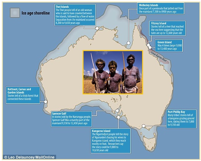
- Stories of Ancient Sea Level Rise have
Survived for 10,000 Years
January 28, 2015
http://www.dailymail.co.uk/sciencetech/article-2929775/Aboriginal-folklore
- Oral folklore tells how the Great
Barrier Reef once formed part of the coastline of north
east Queensland, while Port Phillip Bay in Victoria was
once a rich place for hunting kangaroo and opossum. They
say at this time sea levels rose as a result of the
melting of the huge ice caps that covered much of the
northern hemisphere around 10,500 years ago. The
researchers now believe that these stories could
constitute some of the oldest accurate oral histories in
the world, passing through some 300 generations. If this
is based on true geographical changes, it would mean it
originated at a time when seas were around 100 feet lower
than they are today, making it around 9,800 to 10,650
years old.
But if the Pole Shift 10,800 years ago during the time of the
Flood resulted in higher seas surrounding Australia, the Pole
Shift 3,600 years ago during the Jewish Exodus resulted in a
dropped sea level worldwide. Ocean rifts rip open, allowing room
for water, or new land emerges displacing water. It is a drama
each time.
- Earth in Upheaval by Emanuel
Velikovsky
Chapter: Times and Dates, pp 202-203
http://www.zetatalk.com/theword/tword082.htm
- From observations on beaches in
numerous places all over the world, Daly concluded that
there was a change in the ocean level, which dropped
sixteen to twenty feet 3,500 years ago. Kuenen and
others confirmed Daly’s findings with evidence derived
from Europe.
At one point in the past, there was a land bridge stretching
from Asia to the continent of Australia. The Zetas confirmed a
land bridge to Australia existed in the past when commenting on
Homo Habilis skulls in the Himalayas.
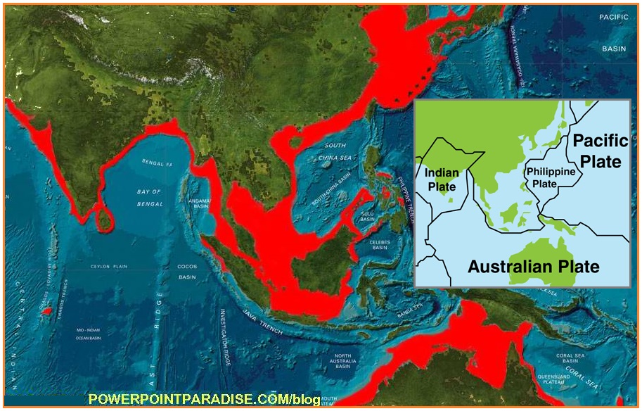
At the present time, the Sunda Plate holding Indonesia is being
pressed down and under the curve of the Indo-Australia Plate.
This has happened in the past, and thus the land bridge became a
series of islands along the curve.
ZetaTalk Explanation
6/21/2014: Early
man roamed to Australia, due to land bridges present in the
past, and throughout China and Russia.
As the Atlantic spreads, it pulls the plates on either side
down, as there is a lack of support for the edges of the plates.
This affects both sides of the Atlantic, the East Coast of the
US, the western UK islands such as Ireland and Scotland, and
Norway. The land that was formerly above the waves can be
readily seen, and often tree trunk stumps or buffalo carcasses
or roads and river beds can be detected.
ZetaTalk Prediction
7/15/1995: As
we have stated, the Atlantic will widen and the Pacific will
shorten. Where the Pacific effect will cause sudden and
violent subduction of several plates, which are already
subducting, in the Atlantic the effect will be the opposite. A
gulf will appear, with plates torn apart and the softer magma
under the plates exposed to the cold Atlantic water. Where
this will harden the magma, and establish new plate surface,
there will be less support for the abridging plates, those
that attach however remotely to the shorelines of the
Americas, Europe, and Africa. These non-supported plates will
sink, somewhat, bringing their formerly above-water land
masses down under the water in many places. As an instance,
Europe and in particular the western islands of Britain and
Ireland will find itself more affected than some other parts
of the globe.
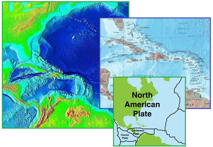
The Caribbean Plate has also been pushed down during successive
Pole Shifts, as the Atlantic has been spreading and the Pacific
compressing throughout prior Pole Shifts, thus the roll of the S
American Plate. The result of this dual effect - a spreading
Atlantic and a sinking Caribbean Plate – is land going under the
waves in the Caribbean and the Gulf of Mexico. At one time there
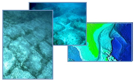
was a land bridge from Florida
to Venezuela, now only a chain of islands. Roads are
visible underwater near the Bahamas.
ZetaTalk Comment
8/27/2011: It
is known that land off the East Coast of the US, and in the
Caribbean, was once above the waves. The remains of forests
can be seen beneath the waves, roads paved with carefully cut
stones, and the clear outline of where rivers cut through the
previous coastal area. It is clear from the ruins in Central
and S America that civilizations existed in the past, and for
reasons mankind cannot fathom, disappeared. The reason man
struggles with this is that denial is much more comfortable.
To imaging cataclysms that could drop the land beneath
civilizations is too horrific to contemplate.
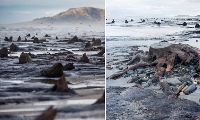
Erratic tides caused by the Earth wobble have revealed sunken
lands surrounding the islands of the UK, as this Pole
Shift ning blog details. Villages and tree trunks are
exposed, dated to the time of the last Pole Shift 3,600 years
ago.
- Prehistoric Forest Arises in Cardigan
Bay after Storms Strip Away Sand
February 20, 2014
http://www.theguardian.com/uk-news/2014/feb/20/prehistoric-forest-borth-cardigan-bay
- Archaeologists also found a timber
walkway nearby, exposed by the storms. It was made from
short lengths of coppiced branches, held in place with
upright posts. It has been dated to between 3,100 and
4,000 years old, built as the local people found ways to
cope with living in an increasingly waterlogged
environment. Human and animal footprints were found
preserved in the hardened top layer of peat, along with
scatterings of burnt stones from ancient hearths.
Across the Atlantic in New Hampshire is more sunken land, also
dated approximately 3,600 years old. Per the Zetas, for the
coming Pole Shift the western UK can expect significant sinking
as can the East Cost of the US from Pennsylvania south through
Florida.
- Sunken Forests of New Hampshire
http://en.wikipedia.org/wiki/Sunken_Forests_of_New_Hampshire
- Near Odiorne Point State Park in
Rye, this sunken forest is referred to as the "Drowned
Forest". The roots of different coniferous trees
(including white pine and hemlock) are visible at most low
tides. Core samples taken from the roots indicate that the
trees are about 3,500 - 4,000 years old. The Jenness Beach
forest, much larger than Odiorne Point, is rarely sighted
above sea level. The trees, eight to ten feet in
circumference, have been carbon dated from 3,400 to 3,800
years old. Some estimates say that the coastline of New
England used to extend 75 miles (121 km) east of its
current position; a Native American of the era could have
walked from Nantucket to southern Cape Cod without
touching the Atlantic Ocean. Fishermen have hauled up
mastodon and mammoth teeth miles offshore, suggesting that
the forest extended quite far from its western shoreline
boundary.
ZetaTalk Prediction
8/27/2011: Just
what part of the western UK will be permanently pulled down
150 feet during the 5.9 days of rotation stoppage is not
clear. We have predicted the UK in general to anticipate a
drop of 75 feet, with Ireland, Scotland and Wales pulled down
potentially by 150 feet, as will the East Coast of the US.
Ireland, Scotland, and Wales face the Atlantic Rift more than
the east coast of England, and thus take the brunt of the
droop. One can see from the underwater shelf that lies to the
west of these islands that this has happened before.
ZetaTalk Prediction
2010: The
New England states will find themselves bouncing up during the
shift, due to the quick ripping of the already separating St.
Lawrence Seaway prior to the shift, where the southern states
will find themselves pulled under the water prior to the
shift. The entire peninsula from central Pennsylvania north,
will experience a bounce, but being on the edge of this drama,
Pennsylvania will have its toes in water but its head above
water. For the East Coast south of the New England area, the
land will drop in sea level, during the shift, 150 feet.
ZetaTalk Prediction
2010: Low
lying lands along the eastern coast of the United States will
be drawn below sea level some 150 feet at the start of the
pole shift, water rushing in over land pulled down temporarily
by the stretch that the sea floor of the Atlantic will
experience.
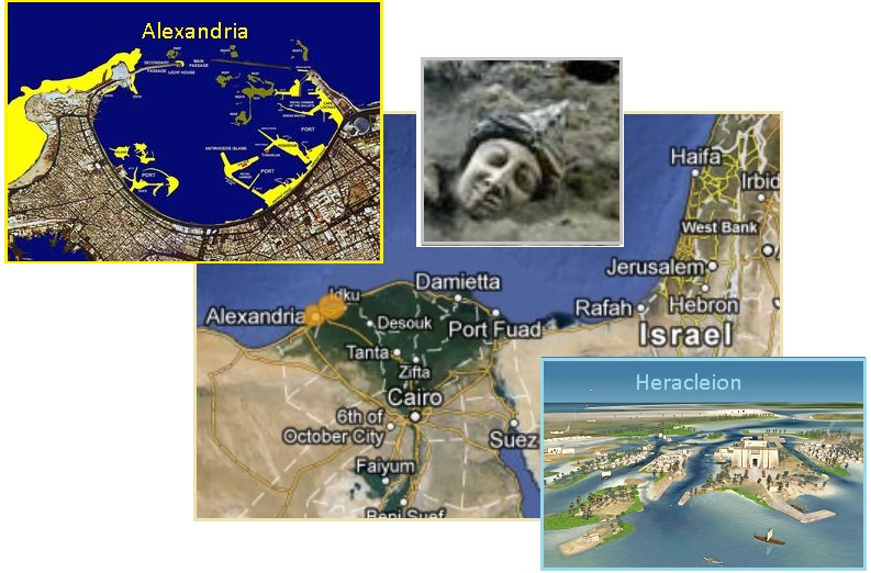
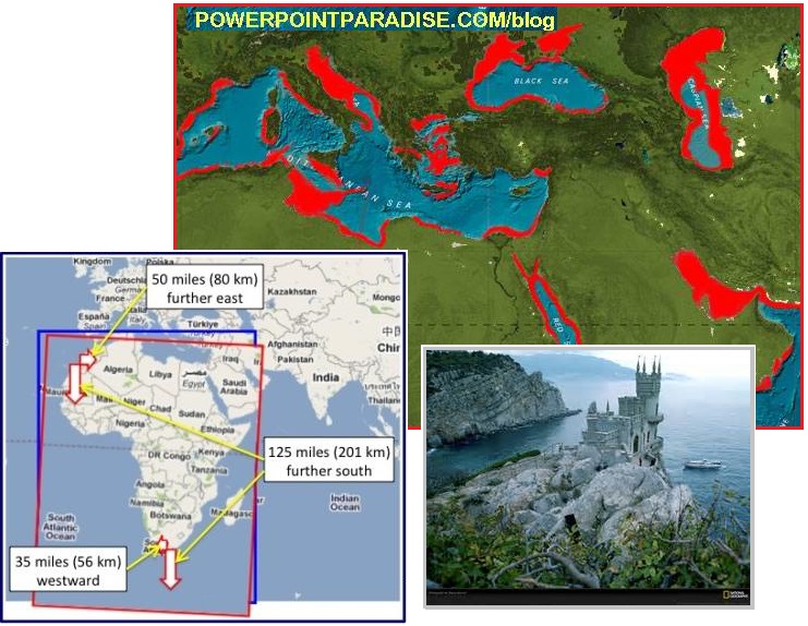
Parts of the Mediterranean have sunk during repeated Pole Shifts
in the past. The African Roll pulls the African Plate from its
attachments in the Mediterranean, so the land on either side of
the rip point loses support. Per the Zetas, the Mediterranean
was once a swamp, allowing migration of early man from Africa to
Europe. This sinking can be seen in the sunken
cities off Alexandria.
The Black Sea turned from a fresh water sea to a salt water sea
approximately two Pole Shifts back - 7,200 years ago. This was
once again due to further sinking of the Mediterranean floor,
the African Plate border tearing away.
- Black Sea Deluge Hypothesis
http://en.wikipedia.org/wiki/Black_Sea_deluge_hypothesis
- The Black Sea deluge is a
hypothesized catastrophic rise in the level of the Black
Sea circa 5600 BC due to waters from the Mediterranean Sea
breaching a sill in the Bosporus Strait.
ZetaTalk Description
2/10/2007: We
have stated that Africa is turning in place, its base at S
Africa firmly nailed and unable to move, the top rolling to
the East as the Atlantic yaws open. This action is what is
causing the African Rift to spread so rapidly, in the Afar
Triangle, where huge crevasses appear before astonished eyes
and the land is dropping hundreds of feet. The Mediterranean
will be destabilized. The African plate is a straight line
across the top, and when it turns it will create a yaw in the
Mediterranean. The Mediterranean, in the past, was a swamp,
but now is a sea. What caused the land to drop? The Black Sea
participated in this drop, being inundated where formerly land
above water. Istanbul lies at the center of the area that will
first be affected when a serious roll of Africa occurs.
Rising land is more difficult to document than sinking land, but
the most dramatic evidence of land rising from the sea is in the
Himalayas. The rock there is composed of sea shells! The
Himalayas were driven high during succeeding Pole Shifts.
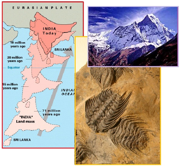
- Geology of Mount Everest
http://climbing.about.com/od/Mount-Everest/a/Geology-Of-Mount-Everest.htm
- At the tops of the highest peaks,
like Mount Everest, it is possible to find
400-million-year-old fossils of sea creatures and shells
that were deposited at the bottoms of shallow tropical
seas that are now over 25,000 feet above sea level. The
summit of Mt. Everest is marine limestone. The sedimentary
rock layers found on Mount Everest are limestone, marble,
shale, and pelite that are divided into rock formations;
below them are older rocks including granite, pegmatite
intrusions, and gneiss, a metamorphic rock. The upper
formations on Mount Everest and Lhotse are filled with
marine fossils.
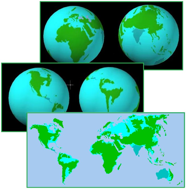
675 Foot Sea Level
Rise
The Zetas have stated that after the Pole Shift, due to a
combination of the former Earth poles melting and deep ocean
water heated by the friction of the crustal shift, the sea level
worldwide will rise by 675 feet. Mankind knows that the seas
would rise 200 feet if the poles and the ice on Greenland
melted. The additional rise would be due to the heat from
friction. This will devastate
many lands, as described at start of the ZetaTalk saga and
as superimposed on the current
Earth globe land placement today.
ZetaTalk Prediction
7/15/1995: After
the cataclysms the existing polar ice will melt, while at the
same time reforming over the new poles. The melting will occur
faster than the reforming. Where new poles take
centuries to fully form, existing poles thrust under an
equatorial sun melt rapidly. The melting poles will thus raise
the sea level, worldwide, by 650 to 700 feet within two years.
Any water at the new poles will freeze, but the buildup of ice
on a pole is not altogether from the water that happened to be
there when the pole took position. The buildup comes from
precipitation, and this accumulates over hundreds of years. At
some point an equilibrium is established, with icebergs
breaking off and floating to warmer waters and the like. The
Earth, therefore, will experience More Water in its oceans for
some time after the cataclysms.
ZetaTalk Explanation
12/25/2010: Water
seeks its level, and when there is an ocean rise anywhere,
this eventually distributes to all shores. The sea level rise,
as we have explained, is due to the heat of friction during
the pole shift, which will heat the deep ocean bottoms. This
heat warms the deep ocean water, icy cold, and thus it swells.
Warm water takes up more room than cold, so the waters of the
oceans rise.
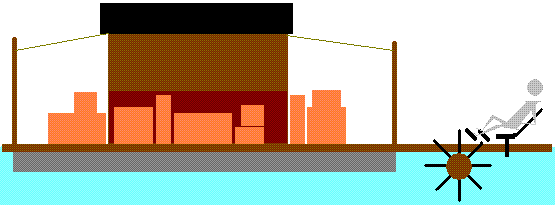
Houseboat Living
What to do when the water is rising and you have to keep
stepping up out of the puddles. Tides roll further inland and
the creeks swell. Rivers don’t drain and the basements start
flooding. The solution? Build a houseboat. Grow key vegies like
tomatoes or kale in containers on the deck. Fish for protein and
if you don’t like the neighbors just pull up anchor and move on
down the changing coastline. Collect seaweed if it floats by and
hang some leftover morsel over the side to collect the crabs or
attract fish. The possibilities are endless. If you don’t
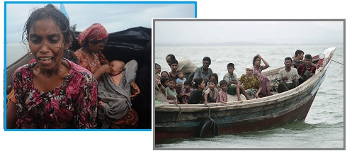
take action, you could end up a refugee
in a boat.
The entire Finegan Fine
script and short story, made available to the public for free,
is based on houseboat living. Situated in the southeast US,
which will be pulled down and lose elevation, the story
endeavors to describe survival techniques in an inundated world,
as in the chapter titled Houseboat
Living. Finegan’s houseboat is powered by a wooden paddle
wheel. While not a speed boat, it gets him up and down the coast
and in and out of swollen rivers, and keeps his legs in shape.
The Zetas have always highly recommended houseboat living.
Siberia, the Amazon basin, the Mississippi valley, Indonesia,
the islands of the new Europe - they all are candidates for
houseboat living.
ZetaTalk Advice
2001: Our
suggestion is to plan for a floating community, as fishing
will be abundant in the Aftertime. Build your boats now, in
anticipation of this. You may be laughed at, as a modern day
Noah, but you will be master of your own country so to speak,
and able to travel where you wish.
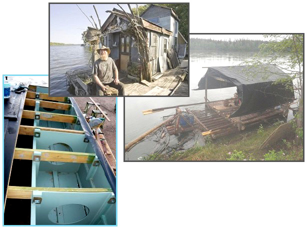
Floatation devices can be anything that hold air and is
airtight. Empty soda bottles from a recycling plant will do, as
used for this Mangrove Island
houseboat. Wood floats, even if water logged, and thus will keep
a houseboat afloat. One could even use concrete if the air is
trapped beneath baffles on the bottom. Be creative! Go have fun!
- Building a Houseboat
http://buildahouseboat.com/
- You can build it on factory-built
houseboat pontoons or build your own wooden pontoons.
|