7 of
10 Arrives!
Java began sinking on December 23, 2010, though this was only
reported as flooding that refuses to drain. This occurred from
one end of the island to the other, and primarily on the
southern side of Java, which is being pulled down. By December
25, 2010 the Indo-Australian Plate began lifting on its eastern
side. And by December 26, 2010 the Mariana and Philippine plates
also began tilting. The buoys from the Philippine Sea to
Tasmania show this, irrefutably. Queensland and the Philippine
Islands suddenly had monstrous flooding due to the water
draining toward the low sides of these tilting plates. Details
on these issues are below, in this newsletter. Of course, as the
Zetas had stated, the trend would be obvious before the
scenarios started to unfold in ernest. This was outlined in Issue 208 of this
newsletter on October 24, 2010, as the drumroll could be heard.
Lets revisit the Zeta 7 of 10 predictions, and the predicted
sequence of events, as they were outlined in Issue 207 of this newsletter on October 17,
2010.
ZetaTalk Prediction
10/16/2010: As the Indo-Australia Plate
lifts and slides, this allows the Pacific plates to shift
west, which allows S America to shift west also. This is
greatly increased by the folding of the Mariana Trench and the
Philippine Plate. But it is the Indo-Australian Plate that
gives way to incite change in these other plates, and this is
what is manifesting now to those closely following the
changes. The sequence of events is, thus a tipping
Indo-Australia Plate with Indonesia sinking, [then] a folding
Pacific.
Because of media suppression of any flooding in Indonesia, the
public is unlikely to learn that this has occurred until it
becomes extreme, within 2-3 of the start, per the Zetas, as
outlined in Issue 217
of this newsletter on December 26, 2010.
ZetaTalk Prediction
12/18/2010: The 7 of 10 will unfold but
not as expected by many. It will not be a dramatic
announcement on the news, as the establishment is ready for
this, due to the extensive discussions. As we stated, there
would be large quakes when Indonesia sinks but not the major
quakes one would expect, not magnitude 8-9. Already there are
many periods when quakes line the plate borders, and hammer
there. During one such episode, the elevation will start to
drop. We have never stated, in our predictions, how fast this
would go, just said "suddenly". The start will be sudden,
almost without warning, but the progress not swift as in the
pole shift hour. It will be a steady sinking, in short bursts,
over a 2-3 week period.
Meanwhile, Indonesian politicians leap in to suppress any hint
that their country is not safe for tourists, as this local
incident shows.
- Psychic's Claims Spook Locals, Hurt
Bookings
December 27, 2010
http://www.bangkokpost.com/news/local/213224/south-upset-by-warnings-of-tsunami
- The government is working to
dispel rumours sparked by a fortune teller that Andaman
coastal provinces will be hit by a tsunami. Anchalee
Vanich, the prime minister's deputy secretary-general and
a resident of Phuket, said a vigorous campaign was under
way to reassure residents and tourists along the Andaman
coast. Residents are frightened after a fortune teller
predicted a tsunami would hit the region on December 30.
Some tourists are reported to have cancelled their hotel
bookings. Kruawan Jankaew, a geologist with Chulalongkorn
University's faculty of science, said there was very
little chance of a tsunami in the near future since there
have been no warning signs.
Thus, the Zetas had predicted that where the first 7 of 10
scenario would arrive by the end of 2010, for the world to
become shocked by the 7 of 10 scenarios would not necessarily
arrive by the end of 2010. But the 7 of 10 scenarios have
certainly begun!
ZetaTalk Statement
6/19/2010: One or more of the plate
movements described would happen by the end of 2010, when a 7
of 10 would have arrived, and that a 7 of 10 would "shock the
world" so that there would be no doubt it had arrived.
ZetaTalk Statement
7/31/2010: A summary of proceedings around
the world could include the Earth changes, where we have
inferred a 7 of 10 would arrive by the end of 2010. We are
currently at a 6 and our statement is that a 7 of 10 would
"shock the world" and be unmistakable. At least one of them
will occur before the end of 2010.
ZetaTalk Statement
8/7/2010: Our prediction that a 7 of 10
will occur by the end of 2010, and will "shock the world".
ZetaTalk Statement
9/11/2010: We have stated that the 7 of 10
will "shock the world", and this has not yet happened.
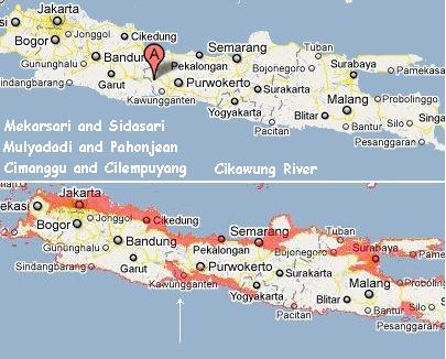
Java Sinking
On December 23, 2010 extensive flooding on Java was reported.
By December 29, 2010 there had been no relief, though
a loss of elevation was not admitted. The identical news
released on December 23 was repeated on December 29. This was
the same pattern with Pakistan, where the flood waters in July
were claimed to be draining, for months, until recently when it
was admitted by NASA that a permanent loss of elevation had
occurred, as outlined in Issue
217 of this newsletter on December 26, 2010. Java lies
along the bottom of the curve of the plate tongue holding
Indonesia, and would likely experience the sinking early in the
2-3 week process. A check on the elevation of these inundated
Javanese locales shows that their elevation is low,
with coastal access, so likely to be inundated by a loss of the
80 foot sea level predicted by the Zetas.
- Floods Hit Six Villages in Indonesia
December 29, 2010
http://www.qnaol.net/QNAEn/News_Bulletin/News/Pages/10-12-29-1625_617_0048.aspx
- Floods inundated at least six
villages in Cilacap District, Central Java Province, the
Indonesian news agency reported Wednesday. "Incessant
heavy rains triggered the floods at several villages. A
Cikawung river's dam also got burst," Among the affected
villages were Mekarsari and Sidasari in Cipari sub
district, Mulyadadi and Pahonjean in Majenang sub
district, and Cimanggu and Cilempuyang in Cimanggu sub
district.
- Floods Hit Six Villages in Indonesia
December 29, 2010
http://www.qnaol.net/QNAEn/News_Bulletin/News/Pages/10-12-29-1625_617_0048.aspx
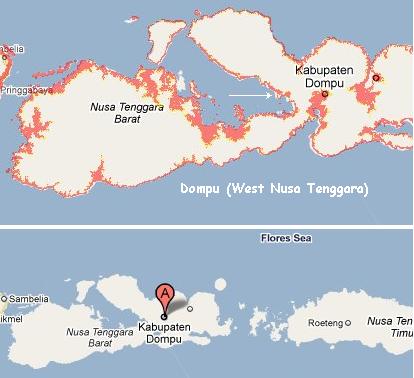
- Heavy floods are still posing a
serious threat in many parts of Indonesia this week,
following inundations in some villages in Cilacap (Central
Java) as well as Lombok Timur and Dompu (West Nusa
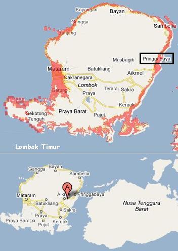
Tenggara). Floods also submerged several hundred houses in
two villages in Pringgebaya subdistrict, Lombok Timur
district, and a number of villages in Dompu district, West
Nusa Tenggara province, recently.
At first, it looked like Lombok Timur was the exception, as it
was not on lowland. But in the earlier article raging waters
from the Kokok Desa River was mentioned, and this rises from the
coastline to Lombok Timur, so that tidal bore could be occurring
there.
- Floods Still Posing Threat In
Indonesia
December 23, 2010
http://www.bernama.com/bernama/v5/newsworld.php?id=552148
- While, Head of Pringgebaya
subdistrict Irpan Widiatma said the floods inundated
Pringgebaya and Pringgebaya Utara villages due to the
overflowing of Kokok Desa river.
All this was predicted in Sabdo Palon's Javanese prophecy, as
outlined in Issue 213
of this newsletter, on November 28, 2010.
Utterly afflicted will be, those
who live in the land of Java. Such is the sign of the
coming of the year. When one crosses a river is an
instance. He is still in the middle of the river when
flash flood comes rushing, its depth drowns men. Rivers
are overflowing so much, looking like high tides. Like
flood tide climbing inland, destroying left and right.
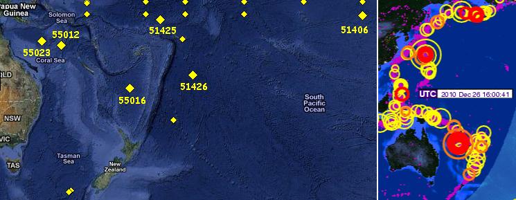
Plates Tilting
The eastern edge of the Indo-Australian Plate is rising. One
can see by the IRIS chart below that the eastern edge of the
Indo-Australian Plate is outlined in quakes, at and just east of
Vanuatu where a magnitude 7.6 quake occurred on December 25,
2010. Vanuatu had 23 quakes over magnitude 5 within a 24 hour
period after that, and continues to be hammered. In the days
following, it was clear from the buoy
alerts in the area that this eastern edge of the plate had
risen!
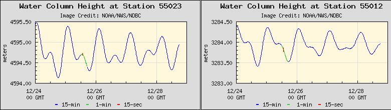
There had been instances this past year when the Coral Sea,
just east of Australia, gave buoy evidence of a rising sea bed,
as noted on July 11, 2010 in Issue
193 of this newsletter. Per the Zetas, the Coral Sea bed
was a weak point in the plate, and was bending under the weight
of the eastern edge of the plate as this side of the plate
tilted up. The Indo-Australian Plate is being tilted and driven
under the Himalayas, thus eventually giving New Zealand and the
eastern edge of Australia an increase in elevation. Buoys in the
Coral Sea are again showing a rising sea bed, by both buoy 55012
and 55023. By December 28, 2010 this was rapidly changing!
ZetaTalk Explanation
7/3/2010: When asked about this in April,
2010 when buoy 55023 first began showing the sea floor rise,
we mentioned not only the steadily rise of the eastern edge of
the Indo-Australian Plate but flexible parts of this plate
while can flex when the plate position changes. Plates are
heavy, and when they are tipped up, they can bend at the point
where they are becoming suspended, bend under the weight of
rock no longer supported by magma. A void is created under
that part of the plate, in essence. The sudden precipitous
drop in water height on June 25 does indeed have a
relationship to the 7.1 quake in the Solomons a day later.
This activity, the lift in the plate, has gotten stronger, and
the trend will only increase in the near future.
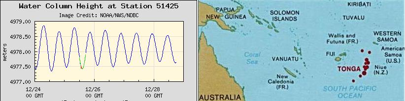
On December 25, 2010, in step with the Vanuatu hammering, the
plate edge itself rose! Buoys 51425 and 51426 east of Vanuatu,
in the South Sea island regions of Fiji and Tonga which ride on
the eastern edge of the Indo-Australian Plate, are showing a sea
floor rise, and by December 28, 2010 this rise was obvious.
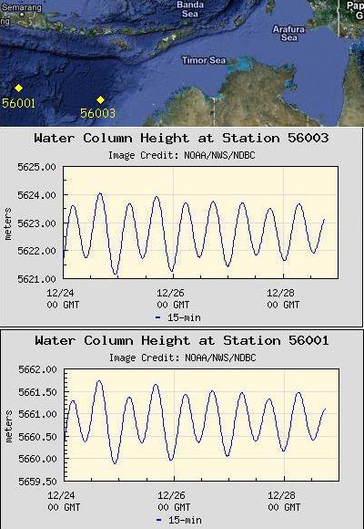
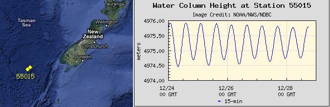
Is the entire eastern edge of the Indo-Australian Plate rising?
Yes! A quick check to see what is occurring south of New
Zealand, or above NW Australia, shows this to be the case! And
rather suddenly! And rapidly since December 26, 2010 it would
seem.
If a plate tilts, will water drain down toward the low end of
the plate? Yes! And this in fact happened along the Queensland
coastline, quite evident by December 29, 2010. Note that the
excessive flooding is all along rivers draining into
the seas to the east along the Queensland coastline. Just where
the draining water from a tilted plate would be trapped and
backwash up the rivers!
- Queensland Flooding 'Could Last
Weeks'
December 29, 2010
http://www.stuff.co.nz/world/australia/4499963/Queensland-flooding-could-last-weeks
- Residents evacuated from flooded
Queensland towns have been warned they may not be able to
return to their homes for weeks. The last of Theodore's
residents were evacuated this morning, with all eyes now
on Bundaberg, where residents are today bracing for the
city's highest flood in 50 years. The evacuation of an
entire town is unprecedented in Queensland. These
floodwaters are likely to remain high for a long period of
time. In some cases that might be measured in weeks,
rather than days. Rail services have been suspended after
water rose over the Burnett River bridge. Evacuations are
also underway in the town of Emerald. Meanwhile residents
in the flood-ravaged town of Dalby on the northern Darling
Downs have just two days' supply of drinking water left
after the region's water treatment plant was inundated.
The swollen Myall Creek inundated more than 100 homes in
the town earlier this week, forcing about 60 residents
into evacuation centres.
ZetaTalk Explanation
1/1/2011: In warning about the effects of
the pole shift tides, we have often mentioned that a slosh can
run UP river. This prevents the rivers from draining, and
thus, rivers will rise beyond their flood level, to an
astonishing degree. Where the current flooding along coastal
Queensland is not due to the pole shift tides, it is related
to the rising of the eastern edge of the Indo-Australian
Plate. As the buoys in the area show, the entire region is
rising. Water trapped between two land masses has difficulty
redistributing quickly and smoothly, as every direction has
water rushing about, trying to find the lowest level. The
sudden rise in the floor of the seas around eastern Australia
caused this water to flow west, primarily, and for the coast
of Queensland, this included flowing up river. There has been,
as we predicted, an attempt to disguise this slosh by pointing
to the weather. Weather reports are pointing to rainfall along
the coast, where this slosh is most noticeable. But why would
rainfall on the coast cause such extensive flooding upriver?
The cover-up over the effects of the plate movements in this
region will not succeed, nor will it fool the public for long.
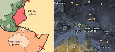
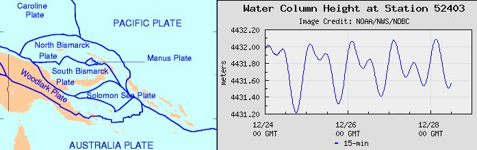
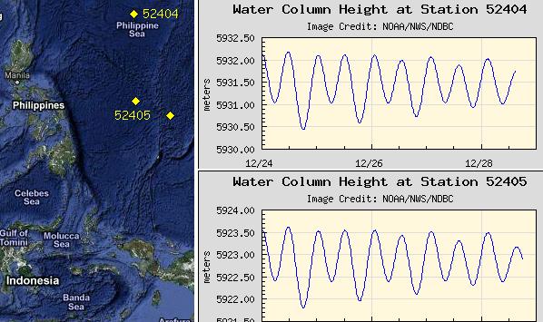
By December 28, 2010 yet more signs of plates rising in this
region occurred. Just north of New Guinea, on the little
Caroline Plate sandwiched beneath the Philippine Plate and above
the northern edge of the Indo-Australian Plate, buoy 52403
showed the sea floor rapidly rising.
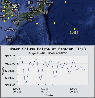
If this plate and the Indo-Australian Plate are rising, due to
pressure from the compressing Pacific, what is happening north
of this location where we expect the Mariana Plate to fold
against the Pacific Plate, rising the eastern edge of both these
plates. Well, these plates are rising, along their
eastern edges! Again, this rise has been sudden, only since
December 26, 2010, as these graphs captured on December 28, 2010
show. The biggest rise, as might be expected, is on the eastern
edge of the Mariana Plate. The plates are folding!
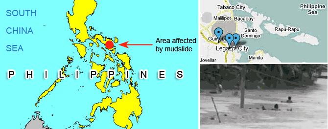
And sure enough, the water draining from the rising Philippine
Sea on the eastern side of the Philippine Plate inundated the
eastern side of the Philippine islands! The 7 of 10 sequences
have begun, have arrived, with much more to follow,
shortly!
- Continuous rains cause landslide,
flood in parts of Albay
December 29, 2010
http://www.abs-cbnnews.com/nation/regions/12/29/10/continuous-rains-cause-landslide-flood-parts-albay
- A heavy downpour in Bicol since
[Dec 28] has triggered landslides and flashfloods in
several parts of the province. Several villages in Legazpi
City were already submerged in flood waters. In Sitio
Capantaran, Imalnod, the river has overflowed. It flooded
rice fields with neck high waters. Flash floods also hit
downtown Legazpi, where several houses were reportedly
submerged. In Albay, 2,719 people from landslide-prone
areas were brought to evacuation centers. Authorities said
the downpour could still last up to 2 days, prompting
Albay officials to prepare relief assistance. The
excessive rainfall was reportedly caused by wind
convergence near the province.
You received this Newsletter because you Subscribed
to the ZetaTalk Newsletter service. If undesired, you
can quickly Unsubscribe.
You can always access prior Newsletters from the Archives.
|