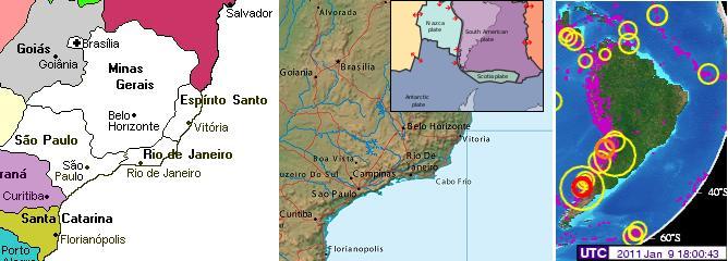
S America Cracking
Is there a relationship between the horrific flooding in SE Brazil and the clustering of large quakes along the
southern Andes recently? Both are occurring at the same time, and are lined up on opposite coastlines across
from each other.
- Rio de Janeiro, Goes Under Water.
January 9, 2011
http://oko-planet.su/pogoda/newspogoda/56709-rio-de-zhaneyro
- At least 35 people died in floods in Brazil. Under the water column, sometimes its level exceeds
the norm by 6.5 meters, were all south-eastern states. The biggest blow dealt by Minas Gerais,
which is the second in the country by population density. Without a roof over his head remained
there for more than 13 thousand people. Fragile buildings simply can not withstand the pressure
element, they were carried over floods and mud flows. Covered with water as Sao Paulo and Rio
de Janeiro. Rains do not stop there for two weeks, reports NTV.
-
- Brazil Government Says 100K Displaced by Floods
January 8, 2011
http://www.forbes.com/feeds/ap/2011/01/08/general-lt-brazil-flood
- Brazilian authorities say the number of people left homeless by flooding has risen to about
100,000 in four southeastern states. Reports from regional civil defense authorities show Minas
Gerais state has been hit the hardest. Eleven more are dead in Sao Paulo state, where 57 cities
are in a state of emergency, including the capital. Main thoroughfares in Sao Paulo city were
swamped Saturday, and some smaller towns were entirely submerged.
Per the Zetas, there is indeed a relationship, and it has to do with the pending S American roll!
ZetaTalk Explanation 1/15/2011: What is the relationship between recent large quakes along the
southern Andes and the horrific flooding in several states in SE Brazil? S America is tugging to the west,
along its top side. The trend has been in place for many months, with the Caribbean Plate sinking just
above Colombia and in Panama. But as much as there is stress along the northern Andes where the S
American Plate slides over the Nazca Plate, there is more stress along the southern Andes. Why would
this be? The rolls that S America and Africa will do is primarily at the Equator, where the spreading
apart of the Atlantic and the compressing of the Pacific is at an accelerated pace. Thus, the plates to the
west of the top of S America have already granted S America room to roll.
But as we have explained, the tip of S America does not roll, but remains nailed in place. This is due to
the Antarctic Plate, which also abuts the south Andes. The Antarctic Plate is not compressing, as it is
one solid piece. For the top portion of S America to roll to the west, something must give, and to some
extent this is the southeastern portion of S America. There is already a seaway developing at Buenos
Aires. But draw a line from the top of the current quake activity along the southern Andes to the east
coast of Brazil and they line up! For S America to be pulled in a bow like this, the land is stretched, and
stretched land sinks. Thus, where they did have rain, the rain was not excessive to the degree to explain
the flooding. The inland rivers are not draining properly, due to the stretch and consequent sinking.
Plate Tilting
If the coastline of Queensland is flooding, with no end in sight, due to the tipping up of the Indo-Australian Plate
and subsequent flow of water seeking its level coming off the high end, is something similar happening to Sri
Lanka? The Zetas predicted, as part of the 7 of 10 sequences, that the Indo-Australian Plate would tilt its
eastern side up by a few feet, and drop its western side by the same amount - a 10 foot rise or fall. Pakistan
already sank by several feet, its July flood waters refusing to drain, as detailed in Issue 217 of this newsletter.
But there has not been any evidence of a tipping up on the eastern side until buoys 56001 and 56003 below
Sumatra and Java showed a rising sea flood, as outlined in Issue 218 of this newsletter on December 31, 2010,
and now the eastern coastline of Sri Lanka awash. Note that only the eastern coastline is awash, and almost
without exception the areas affected are along the eastern coastline and in lowland there with access to the sea.
These flood waters are also intractable, refusing to ease or drain. Water from the eastern edge of the
Indo-Australian Plate is seeking its level there, draining toward the coastline of Sri Lanka. The counts of those
affected keep rising, at last count on January 10 at 750,000.
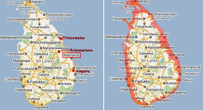
- Sri Lanka's East Coast Battered by Heavy Rains; more Downpour to Follow
January 10, 2011
http://www.asiantribune.com/news/2011/01/09/sri-lanka's-east-coast
- Batticaloa recorded the highest rainfall of 312mm. The entire district faced a power stoppage as
most low line areas in Batticaloa were under water. Sri Lanka's Disaster Management Center
reported that more than nearly 750,000 belonging to 157,738 families have been affected due to
floods.
The tipping of the Indo-Australian Plate was the first in the sequence, per the Zetas, tipping to a predicted 10
foot rise along the curve under Sumatra and Java or a drop on the western side, and this appears to have
happened. And Indonesia has likewise started to sink since the last week of December, 2010, per the Zetas to
occur over a 2-3 week period with an accelerating pace.
ZetaTalk Prediction 10/16/2010: The sequence of events is, thus:
* a tipping Indo-Australia Plate with Indonesia sinking,
* a folding Pacific allowing S America to roll,
* a tearing of the south Atlantic Rift allowing Africa to roll and the floor of the Mediterranean to drop,
* great quakes in Japan followed by the New Madrid adjustment,
* which is followed almost instantly by the tearing of the north Atlantic Rift with consequent European
tsunami.
Meanwhile, the flooding in Queensland, Australia likewise has not abated, and in the coastal city of Brisbane
and upriver from Brisbane, has suddenly worsened. Are we to presume this flash flood is from rain? It washed
away cars and people, per reports. This is a coastal city and a river outlet at Brisbane for the Brisbane River
and the entire Morton Bay drainage region! Meanwhile, buoy 54401 on the eastern edge of the Indo-Australian
Plate is showing that the plate edge is being wiggled, pulled apart.
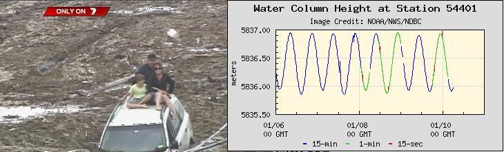
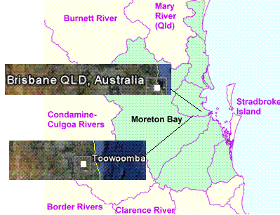
- Wall of Water Sweeps Toowoomba
January 10, 2011
http://au.news.yahoo.com/latest/a/-/latest/8622104/flash-flood
- Toowoomba is in a state of shock after a wall of water, relentless as a tsunami, swept through the
heart of the city. Cars were swept away, houses were ripped from their stumps, and a building has
collapsed. Flash flooding sent up to two metres of water coursing down streets in the city, west of
Brisbane.
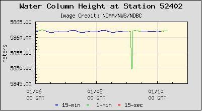
Meanwhile, the Philippines continues to deal with its own devastation, as the Philippine Plate tilts to roll water
onto the Philippine Islands. This, in addition to sinking there. Buoy 52402 in the Philippine Sea shows the
activity there, recording a sudden 35 foot drop in the sea level at one point, a temporary heaving of the sea floor
there.
Flooding Intensifies
The flooding has not drained or eased, but has intensified and has started up in new locations, as noted on the
map below. Where there seems to be a virtual news blackout on news from Indonesia, there was for the first
time and admission of flooding from the sea, a flood tide.
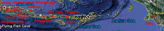
- Hundreds of Houses in Serang Awash Flood
January 10, 2011
http://www.mediaindonesia.com/read/2011/01/10/194560/123/101/
- Hundreds of homes in three villages flooded. Some areas are lowlands around the sea. In addition
to floods caused by rain, residents are also often face rob or flood tides.
-
- Huge Waves Destroy Homes in E Indonesia
January 12, 2011
http://en.vivanews.com/news/read/198818-huge-waves-destroy-homes
- Scores of homes on the coastal area of East Nusa Tenggara were severely damaged by massive
waves of more than 3 meters in height. More than 500 people are seeking refuge to safer places.
43 homes are found destroyed and collapsed into the sea. In addition, dozens of fishermen's boats
were smashed by the waves. Oeba harbor was also thumped by the high waves.
Thailand and in particular the Philippines have been most open in their press. The Philippines not only reports
that the flood waters were not draining, but renewed flooding had begun! Waters up to 10 feet deep are
reported over a roadway. Waves from the sea are reportedly washing houses out to sea. New areas are
experiencing flood too, as indicated on the map below. The Philippine press reports that over a million people
have been affected by the flooding, which of course is the sinking that the Zetas predicted.
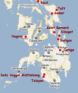
- Heavy Flooding Affects 4,000 Families in Northern Negros Occ.
January 12, 2011
http://www.pia.gov.ph/?m=1&t=1&id=11028
- About 4,000 families were affected from flooding after a day's heavy downpour. Malugo River in
Silay City overflowed. Eighteen out of 28 barangays in the city were affected by the flood.
-
- Borongan's Two Major Bridges Closed Due to Flashfloods
January 11, 2011
http://www.mb.com.ph/articles/297792/borongans-two-major-bridges
- Ten houses that stood by the seashore were likewise taken away by the big, strong waves. The
households, most of whom have quarrying sands and pebbles for a living had transferred to a
higher ground before the waves took their dwellings to the high seas.
-
- Flash Floods, Landslides Threaten Bicol, E. Visayas Anew
January 11, 2011
http://www.gmanews.tv/story/210246/pagasa-flash-floods-landslides
- Flash floods and landslides loom anew over Bicol and Eastern. Flooding of the roadway up to 10
feet high.
-
- 2 Eastern Samar Towns Remain Under floodwaters
January 8, 2011
http://www.pia.gov.ph/?m=1&t=1&id=10650
- Towns of Eastern Samar remain under floodwaters.
One of the first and hardest hit areas on the Malaysian peninsula and in neighboring Thailand was the region
near Kelantan. Press reports from these countries do not deny that the flood waters are increasing, new areas
affected, as the map below indicates, and the situation deteriorating. The whole region is sinking, and not seeing
relief after many days have passed despite admissions of sunny weather!
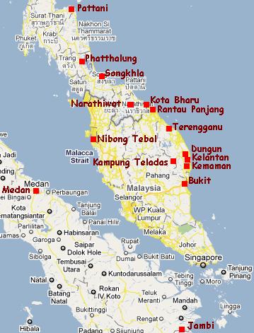
- More Flood Victims Evacuated to Relief Centres
January 8, 2011
http://www.theborneopost.com/?p=85515
- Though the weather was mainly sunny today, intermittent rain and prolonged moderate rain
before today had caused flood water levels to rise. The overall flood situation had deteriorated.
And yet, for all the statements that the region is awash in rain, the claimed cause of the flooding, a village north
of Bangkok in northern Thailand has a river running dry!
- Thailand: Yom River Water Level Plummets
January 10, 2011
http://www.bangkokpost.com/breakingnews/215346/water-in-yom-river
- Farmers in Pho Prathap Chang district face a severe water shortage as the level of the Yom River
has fallen rapidly in the last week. The sharp decrease is affecting farmers who have ben planting
rice for 20 days and need water to flood their fields.
The Malaysian portion of the island of Borneo reports, for the first time, flooding in Kuching, which as with all
other such cases is on the coastline or lowlands with sea access.
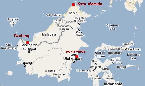
- Kuching Hit By Flood
January 11, 2011
http://www.bernama.com/bernama/v5/newsindex.php?id=555934
- More than 1,000 residents here were evacuated to five relief centres due to flooding. Several
low-lying areas here and in Bau were inundated with up to one metre of water.
More Excuses
While those countries slowly sinking are dealing with the rising flood waters, stubbornly refusing to drain,
excuses for the widespread and increasing flooding are emerging in step with reports of the devastation. The
Philippines has admitted a cyclone was not involved, but continue to blame the flooding on a cold front, causing
rain. Rain, as has been noted, has been the excuse agreed upon by all countries to be affected by the sinking of
the tongue holding Indonesia. But creative excuses have also begun to emerge in the Philippines. The mining
industry is to blame. La Niña and climate change caused by Global Warming are to blame. Anything but the
presence of Planet X in the near vicinity.
- Mining Blamed for Floods, Landslides
January 8, 2011
http://www.sunstar.com.ph/tacloban/local-news/mining-blamed
- The Sagupa-SB blamed mining activities in the region as the culprit for the floods and landslides
in the region, which killing eight persons.
-
- La Niña Affects Eight Regions
January 7, 2011
http://www.pia.gov.ph/?m=1&t=1&id=10565
- These catastrophies have been brought about by the Northeast Monsoon and the tail-end of a
cold front which prevailed over Northern and Central Luzon for the last few days.
The Indonesian press has become very controlled, though they are issuing excuses and trying to lower
expectations.
- One In Three Indonesia's Village Prone To Natural Disaster
January 4, 2011
http://www.bernama.com/bernama/v5/newsindex.php?id=554208
- One in three of Indonesia's 73,000 villages is prone to natural disasters. While 150 cities are
facing the risk of being engulfed by tsunami, 78 cities and districts can be impacted by a volcanic
eruption, 176 districts are prone to flooding and 154 cities to landslides.
In 2011, the extreme weather with the potential of causing floods, flash floods and landslides was
predicted to reach its peak in the January-March period.
And in Australian, it's all the fault of La Niña.
- La Niña and Monsoonal Winds Flood Northern Australia
January 4, 2011
http://www.newscientist.com/article/dn19909-la-nina-and-monsoonal
- Blame the strong La Niña and a monsoonal low-pressure zone for the devastating floods in the
Australian state of Queensland that have left towns and cities stranded this week.
Does the public buy this excuse, especially when any rains have long since passed? Per the Zetas, if they do, it
won't be for long.
ZetaTalk Explanation 1/15/2011: There were several excuses lined up to cover the anticipated sinking on
the plate tongue holding Indonesia. As we mentioned, storm surge, high tides, and Global Warming
were among them. The Philippines has even blamed the mining industry for destabilizing the ground,
causing it to sink. The heads of state of the countries involved - namely Indonesia, Malaysia, Thailand,
Vietnam and the Philippines - kept in close touch, using code words. When Java began to experience
hints of sinking along its southern shores, the rain excuse was selected because at the time there were
showers in the region and there had recently been high winds assaulting the east coast of New Zealand.
They have stuck with this agreed upon excuse long past the point of believability.
Their public of course has noticed that the rain could not have caused this flooding. There are those that
assume that heavy rain may have fallen up river, thus causing the river to burst its banks. There are
those who noticed that the rivers were in a backwash, water coming from the sea rather than from the
highlands, but doubted their eyes and their sanity. But eventually as the sinking progresses and refuses
to abate, word will get around and the public will connect the dots. Then what. The governments know
in the event of our prediction coming true, and the sinking being at the level we have described, that
they will have to admit to a plate movement. They are holding back on this until the last minute, hoping
that the prediction was wrong, so that any sinking will be slight.
ZetaTalk Torrent
A ZetaTalk torrent has been established, accessible from any of the mirror sites, for instance from our Maryland
mirror - http://www.zetatalk5.com/torrent.htm For those who want a copy of their own ZetaTalk and Troubled
Times info, instructions on how to torrent is a click away on the menu bar from the ZetaTalk home page.
You received this Newsletter because you Subscribed to the ZetaTalk Newsletter service. If undesired, you can quickly
Unsubscribe. You can always access prior Newsletters from the Archives.
|