Burma Plate Rising
The plates in Asia have been rising or falling and most often it seems they are undulating. During the
compression of the Pacific, none may be more significant than the rising of the Burma Platelet. The
Indo-Australian Plate tilts the curve under Sumatra and Java up and tilts its eastern edge up. The Fiji Platelet
drops. The Caroline Platelet at first drops and then rises again. The Philippine Plate tips into a greater slant,
stressing the edge near the Bonin Islands. Water washes over Queensland and Sri Lanka and Fiji and to some
degree the Philippine Islands during this process. And of course the plate tongue holding Indonesia is steadily
sinking, as evidence from all countries there show. But for the first time, we are hearing about the Burma
Platelet, which is suddenly rising. A huge rock appeared above the waves.
- Rock Mass Emerges Off Arakan Coast
January 12, 2011
http://www.narinjara.com/details.asp?id=2860
- An amazing rock mass has emerged from the seawater near the offshore islands of Pharonga,
located 20 miles south of Sittwe, the capital of Arakan State. The location of the rock mass is
seven miles south of Pharonga Island, 20 miles southeast of Sittwe. The rock mass is 10 feet high
when the tide is low, and remains five feet above the sea when the tide is high.
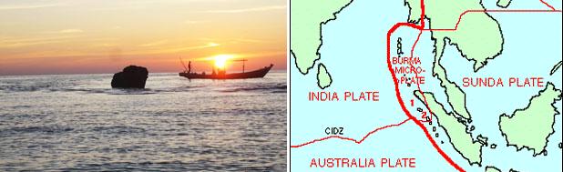
This is significant in showing plate movement, as movement in this plate was the signature movement causing the
December 26, 2004 tsunami near Ache during the massive 9.5 quake that occurred that day. If it's on the move
again, this shows that pressure on the plates in the region is extreme, though the undulating plates certainly have
shown this to be the case.
- Burma Plate
http://en.wikipedia.org/wiki/Burma_Plate
- The Burma Plate is a small tectonic plate or microplate located in Southeast Asia, often
considered a part of the larger Eurasian Plate. To the west is the much larger India Plate, which
is subducting beneath the eastern facet of the Burma Plate. This extensive subduction zone has
formed the Sunda Trench. On December 26, 2004, a large portion of the boundary between the
Burma Plate and the Indo-Australian Plate slipped, causing the 2004 Indian Ocean earthquake.
This megathrust earthquake had a magnitude of 9.3. Over 1600 km of the boundary underwent
thrust faulting and shifted an average of 15 m, with the sea floor being uplifted several meters.
This rise in the sea floor generated a massive tsunami that killed approximately 229,800 people
along the coast of the Indian Ocean.
Per the Zetas, the first plate movement in the 7 of 10 scenarios will be the tipping of the Indo-Australian Plate.
This of course started in July, 2010 when Pakistan began to flood along the Indus River with waters that never
drained, as noted in Issue 217 of this newsletter. The western edge of the plate was predicted to drop by about
10 feet, with the eastern edge rising commensurately. Now Sri Lanka is dealing with horrific flooding, as noted
in Issue 222 of this newsletter. The flooding is occurring only on its eastern coastline, showing that the tipping
plate is pouring water there. The flooding in Queensland also shows water was pouring down from the eastern
and northern edge of the Indo-Australian Plate, causing backwash up the coastal rivers in Queensland. During
this process, plate undulation has presented a confusing picture, but water movement, following plate
movement, is obvious. The plate has tipped.
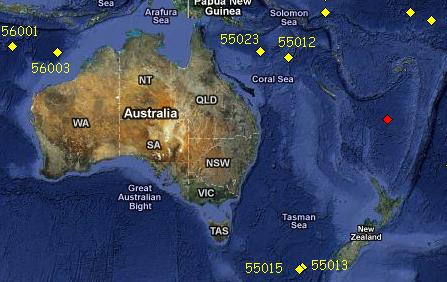
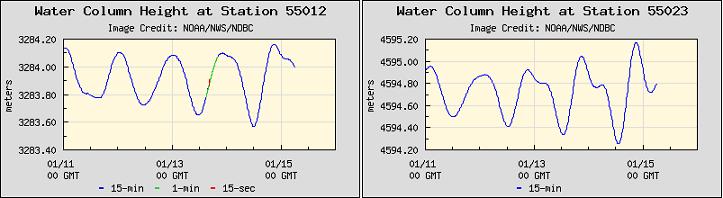
Buoy evidence that the plate tipped can be seen in these buoy charts captured on January 15, 2011. The
process is:
- a rising edge in the curve under Sumatra and Java.
- the Coral Seafloor bend relaxing and straightening out.
- a deepening sea floor near Tasmania.
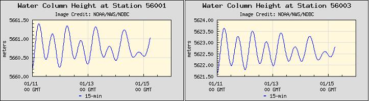
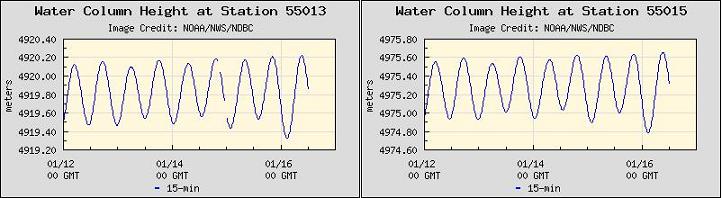
It is the lift in the curve under Sumatra and Java that will allow the plate tongue holding Indonesia to slip down
and under the curve. Where the Coral Seafloor had been rising rapidly just recently, as presented in Issue 223
of this newsletter on January 16, 2011, it suddenly seemed to level out. The tipping of the plate to the side
apparently has relieved the weight of the New Zealand end of the plate, which was causing the Coral Sea bend
in the first place. Tasmania buoys would logically register that the sea flood had been pushed down further
under the waves during the tipping process, since if one side tips up, the other tips down.
Flooding Excuses
The excuse that rain has caused flooding all across the region is wearing thin. From the Philippines to Java,
Malaysia to Bali, and across Thailand and Sumatra, the excuse has been rain - even when the Sun is shining. On
the Queensland coast, terms like King Tide have begun being used, and comments about the utter lack of rain
are hitting the press. In the Philippines the mining industry is blamed for what is obviously sinking land. And
throughout, Global Warming is blamed, as though the sea could rise only in Indonesia. Another approach,
caught by the press recently in Malaysia, is to claim the flood waters are draining when they are not.
- Malaysia: Skiat Baru in Bau still Badly Flooded
January 15, 2011
http://www.theborneopost.com/?p=87528
- Flood waters remained in Kampung Bumbok causing certain areas of the village to be
submerged. A spokesperson when contacted, however said the floodwater in the two villages had
receded. The Borneo Post had been trying to reach the spokesperson since 3.45 pm but all
attempts failed as at press time. Residents in Kampung Skiat Baru were photographed wading
through knee-deep water.
The rainfall excuse grows thin, especially when rain has not been falling! Though mentioned in every article, like
the de rigor comment, the rainfall statistics do not support the claim! Here the flooding in Pati, central Java, is
blamed on "heavy rains" which "continue to fall". Yet a glance at the rainfall chart, per Weather Underground
shows this to be a lie!
- Floods in Pati Spreads
January 15, 2011
http://berita.liputan6.com/daerah/201101/315966/Banjir.di.Pati.Meluas
- The floods that soak 23 villages in Pati, Central Java, widespread. Floods caused by overflowing
Juwana time and unable to withstand heavy rains continue to fall. If there are people who want to
exit the village, they must use boats. Water level had reached 1.5 meters. While in Takalar, South
Sulawesi, the constant rain flushed the area to make hundreds of homes and hundreds of hectares
of rice fields submerged. According to residents, the flood reached two meters.
And a check for other flooded areas, all blamed on rain, show the same lack of rainfall.
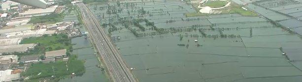
But the most dramatic evidence that a cover-up is in process comes from a private video taken from a plane
descending into Jakarta. This shows the region just to the east of Jakarta, flooded clearly from the sea. The
river in the video is not overtopping its banks. The river is not the source of the flooding, which stands at the
same level as the sea off the coast. This is sinking, the land pushed down below sea level.
VIDEO: http://www.youtube.com/watch?v=KC57GD6MZjA
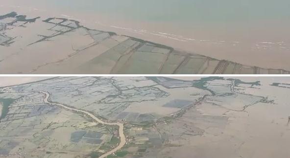
Where not evident from the first video, the plane is landing in Jakarta, which is evident from its companion
video. This is flooding from the sea in Jakarta which is not even mentioned in the press! A forbidden subject.
VIDEO: http://www.youtube.com/user/Setiawanaj
However, the press in Indonesia is beginning to allude to the unusual nature of the flooding, that it is coming
from the sea, that it is not coming from rivers, and beyond anything in memory.
- Thousands of People Displaced Due to Flooding in Larantuka.
Monday, 17 January 2011
http://seruu.com/regional/ribuan-orang-mengungsi-akibat-banjir-di-larantuka
- Residents panic was triggered by the arrival of the flood that is considered not reasonable
because there are no tributaries that pass through residential areas and for the first time this has
happened in the history of disaster in East Flores. Flood disaster in Larantuka said he did occur
almost every year but usually overflowed from a small river from the mountains to the sea which
lies at the center of the City Larantuka, around the palace of King Larantuka.
-
- 1,000 Evacuated as Floods Hit Larantuka
January 17, 2011
http://www.thejakartapost.com/news/2011/01/17/1000-evacuated
- This was the first time large-scale floods have engulfed the area. Every year, Larantuka residents
were affected by floods but they had never been this big before.
-
- Tens of Hectares of Rice in Jepara Awash Sea Water
January 13, 2011
http://www.mediaindonesia.com/read/2011/01/12/194932/124/101/
- Tens of hectares of rice fields in Jepara, Central Java submerged sea water. Waves at the Beach
Village began to rise starting January 1, with waves reaching a height of two meters.
-
- Dozens of Fishermen Unemployed Due to Extreme Weather in Senggigi Beach
January 15, 2011
http://www.thejakartapost.com
- Not only the weather in Jakarta alone is erratic. Extreme weather occurs also felt in the eastern
Indonesian region, precisely at the beach Senggigi, Lombok, West Nusa Tenggara. Tidal wave
rolls accompanied with a height of 1 to 2 meters greet the arrival of tourists in Senggigi Beach.
Per the Zetas, as the sinking continues and reaches the levels expected, the public will connect the dots.
ZetaTalk Comment 1/15/2011: There were several excuses lined up to cover the anticipated sinking on
the plate tongue holding Indonesia. As we mentioned, storm surge, high tides, and Global Warming
were among them. The Philippines has even blamed the mining industry for destabilizing the ground,
causing it to sink. The heads of state of the countries involved - namely Indonesia, Malaysia, Thailand,
Vietnam and the Philippines - kept in close touch, using code words. When Java began to experience
hints of sinking along its southern shores, the rain excuse was selected because at the time there were
showers in the region and there had recently been high winds assaulting the east coast of New Zealand.
They have stuck with this agreed upon excuse long past the point of believability.
Their public of course has noticed that the rain could not have caused this flooding. There are those that
assume that heavy rain may have fallen up river, thus causing the river to burst its banks. There are
those who noticed that the rivers were in a backwash, water coming from the sea rather than from the
highlands, but doubted their eyes and their sanity. But eventually as the sinking progresses and refuses
to abate, word will get around and the public will connect the dots. Then what. The governments know
in the event of our prediction coming true, and the sinking being at the level we have described, that
they will have to admit to a plate movement. They are holding back on this until the last minute, hoping
that the prediction is wrong, so that any sinking will be slight.
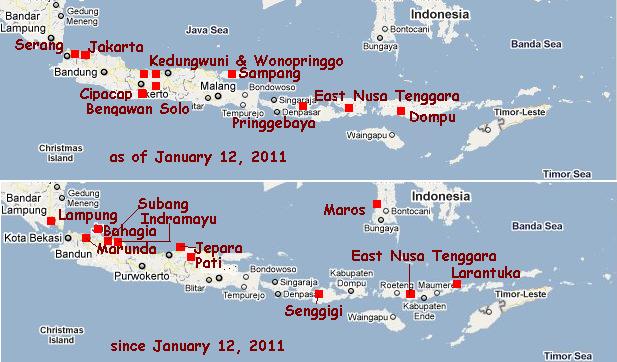
Flooding Status
The articles from the local Indonesian press are too numerous to post in this newsletter, but are listed on this
page, for reference. However, these two articles, addressing the flooding in Subang and Indramayu, Java, show
the rapidly changing situation. One day the count of submerged houses is 3,000, and the next, the count is
11,600.
- Thousands of Homes in Indramayu Awash Flood
January 18, 2011
http://us.detiknews.com/read/2011/01/18/112255/1548964/10/
- Thousands of houses in four villages in Indramayu district inundated. Until now, at least 3,000 of
thousands of homes submerged. At some point, the water reaches a height of 1.5 meters.
-
- Floods in Subang and Indramayu
January 19, 2011
http://berita-komunitas.blogspot.com/2011/01/banjir-di-subang-dan-indramayu
- 11, 600 houses were flooded on two districts in the Coast North of West Java . Yes, floods hit the
coast north of West Java, seven districts in Indramayu district and two districts in Subang
January 18, 2011. Around 5,000 houses submerged in Indramayu and about 1,000 residents were
evacuated. In Subang, 6665 floods submerging houses and 1614 hectares of rice fields. Water
levels rose rapidly.
Flooding in the Philippines made only slight progress, moving westward to the island of Palawan where several
parts of the island were suddenly flooded chest-deep.
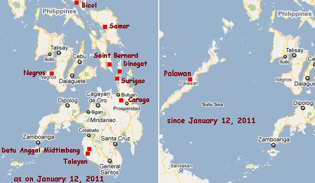
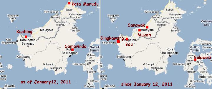
In Sulawesi, Indonesia the news articles went from reporting flooding to stating 2 days later that 1,000 houses
had been inundated, suddenly. The island of Borneo reported that 500 houses in Singkawang had been newly
inundated.
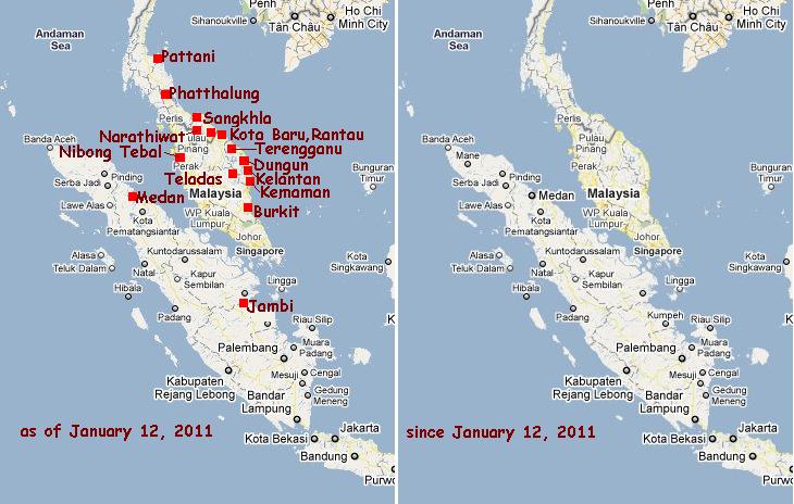
The news from the Malay peninsula was primarily that the floodwaters reported earlier had not drained,
although an attempt to make this statement was made in the Malay press. The press checked, and found the
flooding had not drained, catching the authorities in a lie and rather pointedly saying so, as noted above in this
newsletter.
The big action during the week of January 12 to January 19, 2011 was in Java, where dramatic flooding
occurred along the north coastline to the east of Jakarta. Dramatic flooding images taken from an airplane
preparing to land in Jakarta show the inundated lands at the same sea level as the Java Sea, while a river nearby
stays within its banks, belying the claim that the floods came from rain and overflowing rivers. The entire north
coastline is affected, with the number of homes inundated rising from a count of 3,000 on January 18 to a count
of 11,600 by January 19, 2011 as noted above in this newsletter.
As this newsletter goes to press, the flooding status shows that sinking not only does not drain, it seems to have
doubled within a week, and the excuses proffered by the establishment are no longer covering the immensity of
the flooding. What will another week bring?
You received this Newsletter because you Subscribed to the ZetaTalk Newsletter service. If undesired, you can quickly
Unsubscribe. You can always access prior Newsletters from the Archives.
|