Indo-Australian Tilt
The Indo-Australian Plate is predicted by the Zetas to tilt massively during the hour of the pole shift, driving India under the
Himalayas and even flooding the western 2/3 of Australia.
ZetaTalk Description 4/15/2002: As the South Pole, gripped by the passing North Pole of the 12th Planet, moves north,
the crust is torn from the core and freed in this way, allowing pre-existing stress points to relax. Thus, Europe and Africa
move further east, allowing the Atlantic to rip apart during the slide northward. The immediate effect of the massive plate
housing Europe, Russia and the Near East to move is felt most strongly in India, as the Himalayas are driven over India
at this point, effectively submerging this country in a wink.
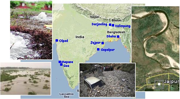
Thus during the 7 of 10 scenarios we have seen this plate steadily tilting, where flooding and crumbling in India have occurred, and
massive flooding along the eastern coast of Australia where the water between Australian and New Zealand was seeking its level,
rolling down the tilt, occurred. This appeared in this newsletter starting on December 26, 2010 in Issue 217 with the flooding in
Brisbane, and again on January 12, 2011 in Issue 226 when the inland sea was trying to find an outlet, with evidence that India
was being pushed under the Himalayas presented on March 27, 2011 in Issue 234. During the week of June 11-18 it was obvious
some tilting had occurred. The gushing of groundwater in Olpad on the west coast shows without a doubt that India is sinking, as
does the inundation by sea water at Gopalpur on the east coast. These news articles appeared in a spate during the plate tilting,
another indication that tilting had occurred.
- Groundwater Gushes Out in Olpad
Jun 18, 2011
http://www.indianexpress.com/news/groundwater-gushes
- Panic gripped residents of Olpad town, 20 km from Surat, as groundwater continued to gush out with high pressure
from bore wells at several places. Many whose homes were affected have started shifting to safer places days after
the phenomenon began.
-
- Sea Water Level Rises Along Coast
June 16, 2011
http://ibnlive.in.com/news/sea-water-level-rises-along-coast/
- Hundreds of families in five villages in coastal areas of the district spent a sleepless night following rise in sea water
level. A team of experts was commissioned to study reasons behind rising sea water in the region. Locals have
attributed the incident to the expansion of Gopalpur port.
-
- Major Landslide at Mapusa, Market Waterlogged
June 17, 2011
http://timesofindia.indiatimes.com/city/goa/Major-landslide-at-Mapusa
- A major landslide was reported at Angod, Mapusa and no business could be done at the town's weekly market due
to flooding. Due to high tide and congested outlets the Mapusa market was flooded. A major landslide was also
reported at Angod, Mapusa.
-
- 3 Feared Killed in Mine Collapse in Western India
June 18, 2011
http://english.peopledaily.com.cn/90001/90777/90851/7413879.html
- At least three persons were feared to have been killed after the tailing stack of a mine collapsed at Cuddegal in
Sanvordem in South Goa, western India. Heavy rains that lashed the state led to the flooding of low-lying areas.
-
- Monsoon Flooding Strands Thousands in Bangladesh
June 17, 2011
http://newshopper.sulekha.com/monsoon-flooding-strands-thousands
- Monsoon flooding has covered low-lying areas of Bangladesh's vast southern coast along the Bay of Bengal,
marooning thousands of people. Incessant rains triggered by a monsoon depression have damaged several flood
protection embankments.
-
- Four Die in Landslide in Darjeeling Hills
June 17, 2011
http://www.thehindu.com/news/states/other-states/article2112556.ece
- A 35-year-old woman and her three children were killed when their house was flattened in a landslide at Kurseong
in Darjeeling hills. In a separate landslide at Kalimpong, National Highway-31A connecting Siliguri with Gangtok
was blocked.
-
- Crawling Baitarani Gulps Land in Jajpur Dist
June 11, 2011
http://www.dailypioneer.com/344954/Crawling-Baitarani-gulps-land
- The Baitarani river that flows past many villages of Korei block in Jajpur district has been gulping land piece by
piece over the decades. And, with the erosion now assuming an alarming proportion, the experts foresee the river
may change its course eventually altering the geographical map of the district.
-
- Flash Floods Reduce Doda to Slush
June 10, 2011
http://www.dnaindia.com/india/report_flash-floods-reduce-doda-to-slush
- Flash floods triggered by cloud burst have wreaked havoc in Doda district of Jammu. A huge mass of slush has
blocked the Doda -Kishtwar highway.
Then a repeat of the flooding experienced last January along the east coast of Australia occurred. Once again, all the flooding was
along the coastline, a backwash up the rivers. Most revealing were comments from a nursery owner in Port Macquarie about the
sea water that had invaded his nursery. This did not come from rain.
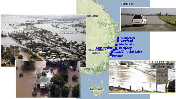
- Looters Harvest Flood-Hit Nursery
June 17, 2011
http://www.portnews.com.au/news/local/news/general/looters-harvest
- The owner of Living Herbs and Cottage Plants has lost stock to something more sinister. 60 plants were stolen
from his property. His remaining plants would survive the soaking if the salinity level stayed low. The water that
was covering his property was mostly fresh water which meant his array of plants would most probably survive.
But, if too much salt water found its way to the stock, he could lose it all. Plants can't handle the saltwater.
-
- NSW Floods Force 1500 to Evacuate
June 15, 2011
http://www.3news.co.nz/NSW-floods-force-1500-to-evacuate/tabid/417/
- Residents of Kempsey are bracing themselves for a major flood in the mid-northern coastal town. Motorists have
been urged to avoid coastal highways in the area.
-
- Anxious Wait for Flood-Hit Northern NSW
June 15, 2011
http://www.abc.net.au/news/stories/2011/06/15/3244353.htm?section=justin
- The SES is warning motorists to drive carefully and avoid floodwaters with the Pacific Highway flooded at
Macksville, Corindi and Kempsey.
-
- SES Warn of NSW Flash Fooding
June 16, 2011
http://www.skynews.com.au/eco/article.aspx?id=626027&vId=
- The Pacific Highway has been cut off between Port Macquarie and Clybucca on the mid north coast after
widespread flooding and State Emergency Services minister Michael Gallacher has declared the areas of Clarence
Valley, Upper Hunter, Bellingen Shire and Kempsey natural disaster zones.
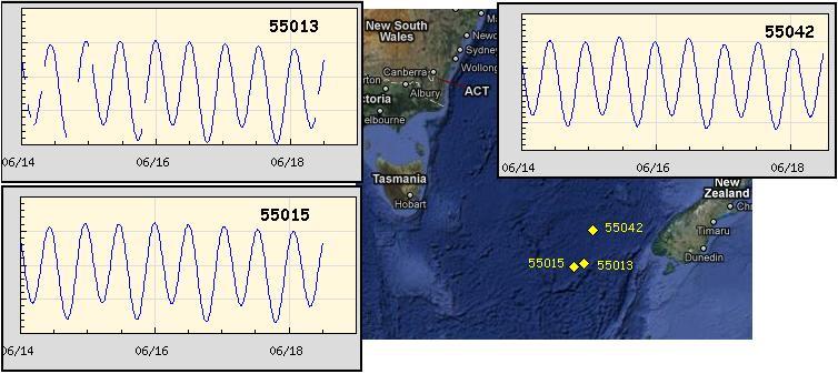
The buoys in the Tasman Sea also indicated a temporary rise in the water level as the water between Australia and New Zealand
sought to find its level, disbursing during this week.
Lack of Warning
With the cover-up in place, how much warning will the common man have from their governments going into the New Madrid
adjustment and the horrific tsunami predicted to strike Europe shortly after the New Madrid adjusts? The Zetas were asked this
question during a recent chat. Best advice, watch the Earth changes and do not watch the USGS reports to determine when the
New Madrid had finally adjusted.
ZetaTalk Advice 6/18/2011: It will not be a lack of information from the USGS that will be the point of confusion during
the earthquakes leading up to the New Madrid adjustment, it will be knowing which quake is the BIG one vs the many
minor quakes preceding it. The USGS downgrades almost all earthquakes, to prevent meaningful statistics from being
generated from their databases. They also exclude quakes whenever they can, but this is unlikely to happen in the New
Madrid area as it is in the center of a populated land mass. Thus you will have magnitude 6 quakes that will be called a
5.2, magnitude 7 quakes called a 6.1, and when a magnitude 8 or greater quake occurs, it will be called a 6.9.
We would advise that rather than watching the USGS quake statistics, that you watch the Earth changes. The adjustment
that will incite the European tsunami will involve bridges on the Mississippi breaking, and being impassable. The land to
the west of the Mississippi will drop so that the Mississippi will become 50 miles wide in the state of Mississippi. Watch for
this. The New Madrid adjustment will be several large quakes of magnitude 8-9, though will be listed as a lesser
magnitude. As the N American continent continues to unzip up to and along the Seaway, the quakes will be less than a
magnitude 8 but very destructive to Cleveland and Toledo and Buffalo and the inland locks along the Seaway. Thus it is
not what the USGS says that should be watched, but the condition of the bridges on the Mississippi, the impact on the
cities along the Seaway, and whether the inland locks are reported as inoperable.
Will Europe step up to the plate and warn their people about the pending tsunami? Per the Zetas, this simply will not occur.
ZetaTalk Advice 6/18/2011: Every step toward honesty brings about intense pressure not to break the cover-up, and by
pressure we mean not only economic pressure but death threats. These forces, to tell and not to tell, rise and fall like
waves, together. This leaves the governments of Europe with few choices. They can either hold firm and say and do
nothing, allowing the cover-up full sway in the absence of truth, or they can institute conservative steps such as a tsunami
warning system or evacuation plans. Norway and Sweden are likely to do the latter, with tsunami drills for practice.
Europe is not without a tsunami warning system, and this can be enhanced with additional buoys. Tentative plans for one
country to support another have been discussed but no agreements made, nor are there likely to be any. Countries where
devastation is likely to be immense, such as the UK and Denmark and the Netherlands, will likely take no steps beyond
participation in bolstering the warning system. They will be reactive, sounding the tsunami alarms and then mopping up
afterwards, sorting through the bodies prior to burial in mass graves.
How will it be possible to ignore all the 7 of 10 scenarios, especially when the African Plate drops? Is the elite grip on the media so
strong that they can keep this out of the news?
ZetaTalk Advice 6/18/2011: Our 7 of 10 predictions have been known with great specificity since the Fall of 2009. The
cover-up over the nearby presence of Planet X and the pending passage of course quickly formulated a list of topics the
media, which is firmly in their grasp, should avoid. The word "sinking" should be avoided for Indonesia and the countries
on the Sunda Plate, as was obvious when all flooding had to be ascribed to "rain" even when rain was not present.
During all of this, the Internet, primarily the Pole Shift ning, has reported the truth, in step with intense discussions on
why the Sun appears too far north. The cover-up has created a monster they will not be able to control, as concerned
citizens of the world are seeking their answers on the Internet, not from the press, and once this process has begun it
cannot be reversed. A distrust develops, so the press is only checked to determine the posture of the establishment and
then the Internet is checked for the truth.
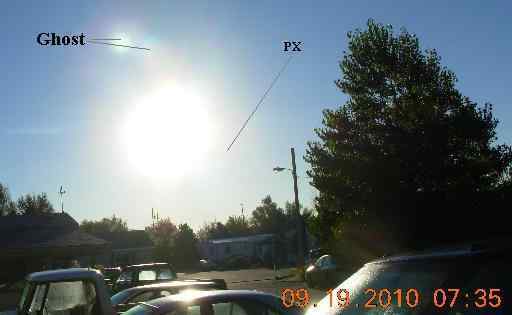
Lens Flare Confusion
Eager to get a capture of Planet X or its Moon Swirl orbs on film, many take to their cameras, with glare filters, or examine
webcams for signs. It can be a very confusing picture. Without glare filters, Sun "ghosts" or reflections of the Sun can be included.
Lens flares also occur anytime a very bright object is recorded, but are usually identified as they string out in a line from the Sun.
Certainly, any captures of a sundog, those rainbow colors orbs that form along a halo around the Sun, should be eliminated early.
That said, have there been any captures of note, late? There have indeed. The Zetas replied to photos and videos taken with Sun
glare filters presented during the weekly chat on June 4 and June 11, 2011.

ZetaTalk Analysis 6/4/2011: This video was taken with an expensive camera, a point the poster touts with pride as he
announces his discovery. He takes his audience through the steps by which he examines his video with color
enhancements. The captures are genuine, despite the poster now claiming he thinks they are lens flares. Not all who
capture evidence of Planet X and its Moon Swirls can withstand the heat they come under when they go public. The large
orb at 4 o'clock, which the poster correctly identified as the prime suspect, is the Planet X corpus itself. There are Moon
Swirl orbs likewise in view, at 9, 11 and 2 o'clock. These orbs are caused by Moon Swirls turned so their tubes are in a
line from the Sun, thus funneling light down their tubes like a flashlight.
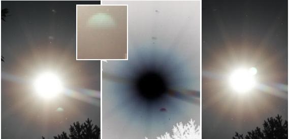
ZetaTalk Analysis 6/11/2011: With reduced glare due to filters, these photos are showing not only Planet X itself at the 4
o'clock position but various Moon Swirl orbs clustered around the Sun. The appearance of Planet X, where there is a
shadow below the orb, is due to the angle of reflection off the dust cloud on the top of Planet X, thus the shadow. The
smooth shape of this presentation of Planet X is because the light reflections are illuminating the dust cloud as in the
Monster Sun category, scattering light out and then bending back, giving a large, or monster, appearance.
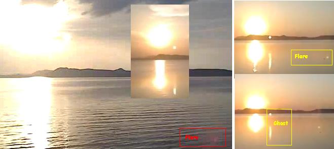
There can also be a combination of a true capture and lens flares or ghosts, as in a photo presented to the Zetas during the
September 7, 2010 weekly chat.
ZetaTalk Analysis 9/25/2010: This is a complicated photo as it does include ghosts and flares, but also has an even and
unencumbered glow around the Sun for the bottom and sides and this includes a valid capture of Planet X during the day
at the 4 o'clock position.
A very tempting video from Hungary, on a long-exposure webcam positioned on Lake Balaton, appeared to show Planet X at the
4 o'clock position and a matching reflection on the lake. A reflection from the Second Sun is normally proof positive of a valid
capture, but there are indications this second reflection is a ghost. The Sun and its reflection are both ghosts in the camera, to the
right and down. This is evident from the second reflection starting offshore, down from where it would normally start. And captures
on other days clearly show what might be assumed to be Planet X as a Second Sun as a reflection of the Sun, as it stands in front
of the mountains and on the water.
Omaha Close Call
There is certainly a difference from the nuclear power plant disasters at Fukushima due to a magnitude 9 earthquake and tsunami
and any distress at the Omaha nuclear power plant due to spring flooding on the Missouri River, but the incident shows how
vulnerable these power plants are. A cooling pond had an electrical failure, due to a fire, and the main reactors were threatened by
the flood waters. Sound a little too familiar? The Fort Calhoun plant in Nebraska is the smallest plant in operation in the US, with a
single reactor.
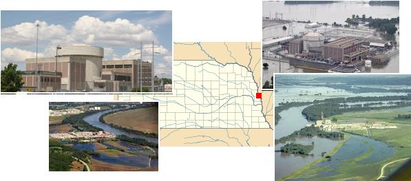
- Nebraska Nuclear Plant Safe from Flooding, Officials Say
June 18, 2011
http://www.denverpost.com/nationworld/ci_18303178
- Nuclear regulators and the utility that runs the Fort Calhoun reactor say there is little cause for concern. The plant,
encircled by a giant rubber barrier against the water, has been shut down since April. The Omaha Public Power
District said the complex will not be reactivated until the flooding subsides. The building housing the reactor has
been fortified with steel plates on the outside and a series of internal barriers. The pool that holds radioactive spent
fuel is in an elevated structure several stories above the rest of the power plant, so the waste is well-protected from
floodwaters.
-
- Fort Calhoun Nuclear Power Plant
June 6, 2011
http://hisz.rsoe.hu/alertmap/woalert_read.php?edis=NC-20110620-31229-USA
- A fire in an electrical switch room briefly knocked out cooling for a pool holding spent nuclear fuel at the Fort
Calhoun nuclear plant outside Omaha, plant officials said. Officials at Fort Calhoun said the situation at their plant
came nowhere near to Fukushima's. They said it would have taken 88 hours for the heat produced by the fuel to
boil away the cooling water. The fire led to the loss of electrical power for the system that circulates cooling water
through the spent fuel pool, according to a report from the Nuclear Regulatory Commission. Fort Calhoun has a
backup pump to provide water to the spent fuel in case the main system is lost.
You received this Newsletter because you subscribed to the ZetaTalk Newsletter service. If undesired, you can quickly Unsubscribe.
|