Shrinking
Britain
Both off the western coastlines of Europe and the eastern
coastlines of N America, land is being pulled down during the
periodic passages of Nibiru, aka Planet X. On both sides of the
widening Atlantic Rift, one can look beneath the waves and see
where rivers have carved out their paths, tree trunks still
remain, and the tracings of cities. The UK is expected to be
pulled down along its western edge during the pending Pole
Shift, per the Zetas, but how much has this occurred in the
past? Per a recent analysis by scientists working primarily for
the oil companies in the North Sea, the UK was an extensive land
mass.
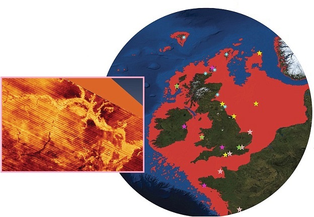
- 'Britain's Atlantis' Found at Bottom
of North Sea
July 3, 2012
http://www.dailymail.co.uk/sciencetech/article-2167731/Britains-Atlantis-North
- Doggerland, a huge area of dry
land that stretched from Scotland to Denmark was slowly
submerged by water between 18,000 BC and 5,500 BC. Divers
from oil companies have found remains of a 'drowned world'
with a population of tens of thousands - which might once
have been the 'real heartland' of Europe. A team of
climatologists, archaeologists and geophysicists has now
mapped the area using new data from oil companies - and
revealed the full extent of a 'lost land' once roamed by
mammoths.
Note the date range quoted! Even though precise date
calculations are not possible, the record of when old Britain
was periodically submerged shows increments of 3,657 years, per
the Zetas the cyclical return of Planet X! Per the Zetas,
Britain has been regularly jerked around during prior Pole
Shifts.
- (5,500 BC + 2012) = 7512
(2 *3657) = 7,414
ZetaTalk Explanation
2/15/2002: The
prior shift moved the North Pole from Greenland to its present
location. Prior to that, it was over the East Siberian Sea,
having pulled Siberia northward where the largest number of
mammoth dieoff occurred. Tracing the North Pole over the past
few shifts, one sees that it spent a time over Scandinavia
where it resided between the 4th and 5th shift back. When it
moved from Scandinavia into the Arctic north of Siberia,
Europe warmed up, its glaciers melting. Prior to Scandinavia,
the North Pole centered over North America.
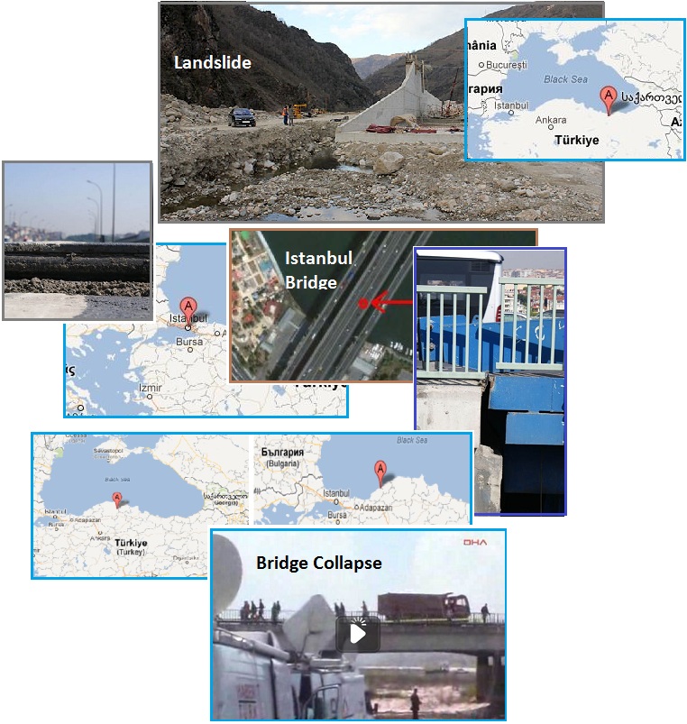
Black Sea Stretch
Just as Britain is being pulled down during the plate movements
preceding and during the Pole Shift, the Eurasian Plate to the
east of Britain is likewise being stretched. A series of
accidents in May, 2012 in Turkey along the shores
of the Black Sea show this tension – landslides and
collapsed bridges, including the main bridge at Istanbul. The
Zetas predicted that Istanbul would be greatly affected during
the 7 of 10 African Roll. The bridge at Istanbul simply
pulled apart, for no reason. Construction or maintenance was not
a factor. No impact or excessive weight had occurred. The bridge
just pulled apart, obviously stretched. Combined with other
accidents along the shores of the Black Sea during the month of
May, it is obvious this region suffered a stretch during May,
2012. Such is life in the stretch zone.
ZetaTalk Prediction
3/26/2011: When
the 7 of 10 scenario for Africa occurs, dropping Africa and
widening the Red Sea, the isthmus holding Istanbul will
tear, dropping the city into rubble.
- 4 Dead in Landslide at Hydroelectric
Power Plant Construction Site
May 15, 2012
http://www.todayszaman.com/news-280416-4-dead-in-landslide-at-hydroelectric-power-plant
- Four people died in a landslide
at a hydroelectric power plant construction site in
Dereli, a district in Giresun province.
- Turkey: Emergency and Danger of
Collapse at Main Istanbul Bridge
May 22, 2012
http://www.dha.com.tr/halic-bridge-closed-due-to-broken-screws-son-dakika-haberi_315730.html
- Istanbul’s one of the busiest
bridges, Halic Bridge, was closed to traffic after some of
screws holding the bridge got broken, and raised it about
7-8 cm from the road.
- Turkey: Another Bridge Collapsed at
Black Sea
May 28, 2012
http://www.posta.com.tr/video/video-izle/?VideoID=7078
- Bridge located at
Taskopru/Kastamonu partially collapsed.
Now in July, 2012, the stretch is still in process. Phenomenal
flooding once again along the coastline of the Black Sea,
shows that dams in the region have been fractured and weakened,
giving way for a flood the residents say was the worst in
memory.
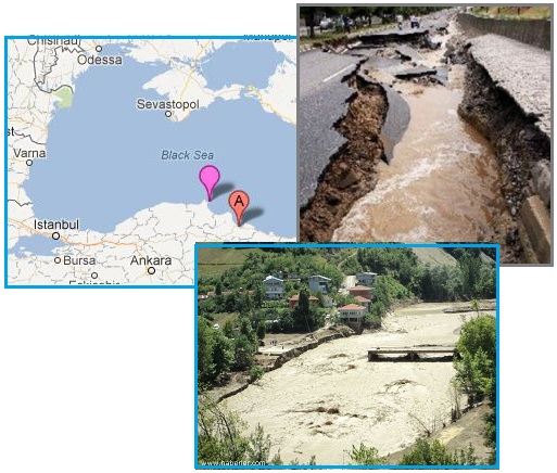
- Turkey: 8 Killed, 21 Injured in
Flooding and Damages in the Black Sea Provinces
July 4, 2012
http://www.todayszaman.com/newsDetail_getNewsById.action?newsId=285463
- Flash flooding caused by
torrential rains killed eight people, including at least
four children, in the Black Sea province of Samsun.
What makes this particularly synergistic are reports from the
Balcans of a sulfur smell, a component of lava flows. Is magma
rising in the Balcans? The Balcans are high ground, mountainous,
and not notable for volcanism. Per the Zetas, the sulfur smell
is due to deep crevasses allowing magma to rise, but this will
not result in new volcanoes.
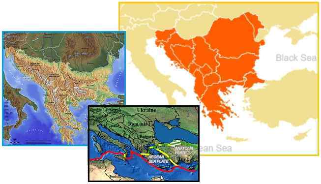
- Somewhere in Balkans, I have
noticed hydrogen sulfide odor in the water-well, root
cellar and on the open field. Also one water-well that has
been giving drinking water to the local population
for centuries has dried up. Can the Zetas answer what
could be the reason for this sulfur smell, what risks it
poses and could it be a precursor for some greater things
that could happen.
- Balcans
http://en.wikipedia.org/wiki/Balkans
- The Balkans, often referred to as
the Balkan Peninsula, although the two are not
coterminous, is a geopolitical and cultural region of
southeastern Europe. The Balkans are highly mountainous;
Mount Musala (2,925 metres (9,596 ft)) in the Rila
mountain in Bulgaria is the highest.
ZetaTalk Explanation
7/7/2012: The
Balkans are in the stretch zone, as the singing reservoirs of Kiev
and the bubbling mud
in the Azov show. The
Eurasian Plate is being pulled from Scandinavia through to the
Himalayas, with river bottoms pulling apart and sinkholes
appearing. The crust in a stretch zone will primarily give
where it is thin, along river bottoms, but even in mountains
there can be deep crevasses where the rock has fractured
during past pole shift upheavals. Such crevasses allow lava to
rise up, and a clue to this is the sulfur smell. Does this
mean that volcanoes will emerge? Unless there is collateral
pressure in the lava, such breaks in the crust do not result
in volcanic action. Under the Balcans, the pressure is
relieved by the volcanoes in the Mediterranean, ripping open
as Africa continues to drop during its 7 of 10 roll.
And to show the relationship to plate movement, the 7 of 10
African roll, quake
swarms on el Hierro in the Canary Islands starting in
late June showed that the African Plate is again on the move.
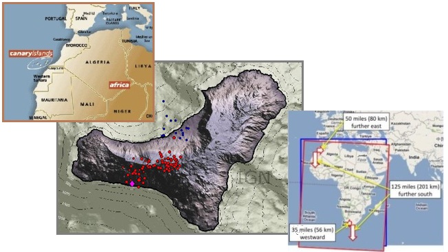
- Signs of Revived Activity at El
Hierro in the Canary Islands
June 25, 2012
http://www.wired.com/wiredscience/2012/06/signs-of-revived-activity-at-el-hierro
- Over the last few days,
seismicity under the island has resumed and its
manifestation is very similar to what we saw last summer
during the lead up to the eruption of El Hierro in October
2011. Over 50 earthquakes have been recorded at El Hierro.
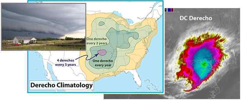
Derecho Develops
Per statistics, Washington DC should not have experienced a
Derecho. What is a Derecho, you ask, as the term is not commonly
used. A Derecho is a straight line wind storm that builds
upon itself. Cold dense air rushing into superheated moist
air, with resulting up and down drafts, is what causes
thunderstorms and tornados. In a Derecho, the push is so rapid
that the rain laden clouds do not climb up as much as lateral
atop the cold air mass, thus creating a circular route for the
rain and rapidly cooling air, which drops into the cold air
mass, increasing this, and thus, the Derecho builds.
- Origin and Evolution of the Term
Derecho
March 18, 2007
http://www.crh.noaa.gov/images/dvn/hinrichs/JohnsDerechoStory.pdf
- The nature of damaging winds
associated with severe convective storms varied
considerably. Many of these events were non-tornadic
convectively induced winds associated with a violently
progressive mass of cold air (Galway 1984). The term
derecho (Spanish for “direct or straight ahead”) to define
these non-tornadic events since this term could be
considered as an analog to the term tornado which is also
of Spanish origin (Ludlum 1970). Since the 1987
publication, the term derecho has become more commonly
used in describing long lived convective straight-line
wind events that have occurred and many research studies
have been directed towards derecho events. Derecho events
have been documented in North America and Europe.
This happened on June
29, 2012 when a Derecho began in Indiana and
increased in strength, up to hurricane force winds, all the way
to Washington DC.
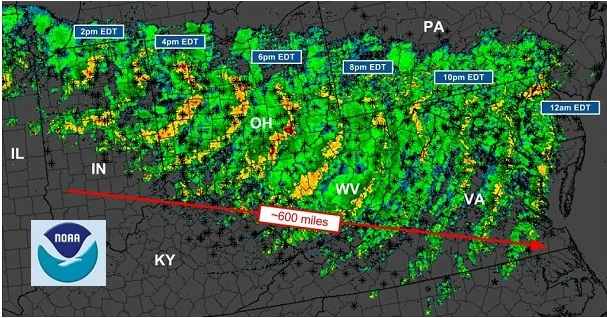
- D.C. Derecho: Midwest to East Coast
Destructive Storms
June 30, 2012
http://www.wjla.com/blogs/weather/2012/06/d-c-derecho-midwest-to-east-coast
- The line of storms produced wind
gusts to 70 mph at both Reagan National and Washington
Dulles. The storms lasted about an hour, but left
millions without power and unfortunately a few
fatalities. Looking back at weather records, D.C.
hasn't experienced a significant Derecho event before the
Friday occurrence. The 2012 D.C. Derecho will definitely
make the record books
- Power Outages from Storms Across
Mid-Atlantic Could Last for Days
July 1, 2012
http://www.huffingtonpost.com/2012/07/01/power-outages-storms-mid-atlantic_n_1640946.html
- Utility crews untangled downed
power lines and tree limbs Sunday, working to get the
electricity turned back on for millions of people facing a
second day of 100-degree temperatures without modern
conveniences like air conditioning and refrigeration. When
a hurricane is lumbering their way, state officials have
time to get extra personnel in place so they can
immediately start on cleanup. That wasn't the case with
this storm, known as a derecho – a straight-line wind
storm that sweeps over a large area at high speed.
Per the Zetas, this is a direct result of the Earth wobble,
which has gotten more severe of late. They predict more of this
in the future, as the traditional wobble pattern creates an air
trap over the continental US.
ZetaTalk Explanation
7/7/2012: Derecho
events are not new, nor is the term new, though these events
are increasing in frequency and size. Storms, complete with
sudden deluge and winds, are caused by factors such as
temperature differences, humidity, and air pressure dynamics.
Essentially, cold air, which is heavier than super heated air,
pushes in, pushing the hot humid air UP causing rains. During
a Derecho, these factors are exaggerated, the differences
greater, so the cold air moves more rapidly. A Derecho will
build upon itself, causing the hot, humid air to dump its
water and suddenly cool, adding to the force pushing the cold
air forward.
During the Earth wobble, where N America leans to the right at
sunrise and then into an upright up/down pumping action later in
the day, hot air tends to get trapped overland. The lean to the
right pushes it back, so it cannot flow to the east. Then the
globe gets the magnetic N Pole pushed away over the horizon by
Planet X, so cold air cannot flow down from Canada as there is a
knot of high pressure over the central US. Will Derechos
increase as the Earth wobble gets more severe? Unfortunately,
yes, but the wobble can also become complicated, slinging side
to side as well as its routine Figure 8 pattern, and if this
occurs, the weather will become even more interesting.
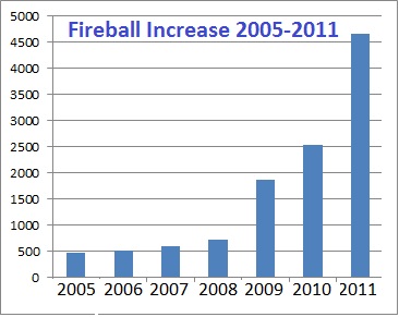
Fireball Increase
Fireballs were much in the news when they first were on
the increase, shortly after Planet X entered the inner
solar system in 2003. Prior to that, such bolides were quite
rare. But as they started regularly screaming across several
states or provinces, such news was suppressed as they
could not be adequately explained as meteor showers or space
junk. Thus, the common man does not get a sense of their
increase, as the vast tail of Planet X is pointed toward Planet
Earth, and as Planet X draws ever closer. But statistics
are maintained and as this Pole
Shift ning blog shows, the increase in fireballs is
astonishing, a 10 fold increase between 2005-2011, with the rate
rising still in 2012.
- 2005==>466
2006==>515
2007==>587
2008==>726
2009==>1,872
2010==>2,538
2011==>4,663
2012==>2,684 (through June 30)
An example of the fireball increase is this flaming fireball
which dove
into the sea at sunset off Perth, Australia on July 1,
2012, captured on film by more than one person. The composition
of the tail of Planet X is no secret, as the Zetas explained at
the start of the ZetaTalk saga in 1995.
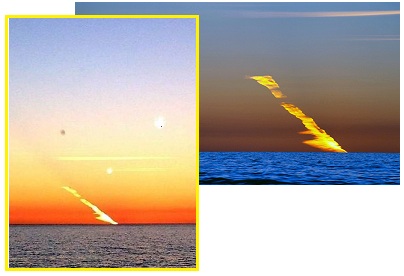
ZetaTalk Description
7/15/1995: The
tail has dust, gases, stones, boulders, and moons, depending
on the size and composition of the entourage at any given
point. The Solar wind, a bombardment of radiation your eye
cannot see except as light, pushes the tail outward, away from
the Sun. Thus the tail of Planet X sweeps the Earth - dust,
gases, stones and boulders all.
Costa Rica Crush
The Zetas predicted that the Caribbean Plate will tilt and be
pushed down on its southern side during the 7 of 10 S America
roll, and the little Panama platelet which lies under Costa Rica
and Panama most vulnerable to upheaval during this process. If
mountain building is occurring up and down the Andes, the Panama
platelet has certainly not been left untouched.
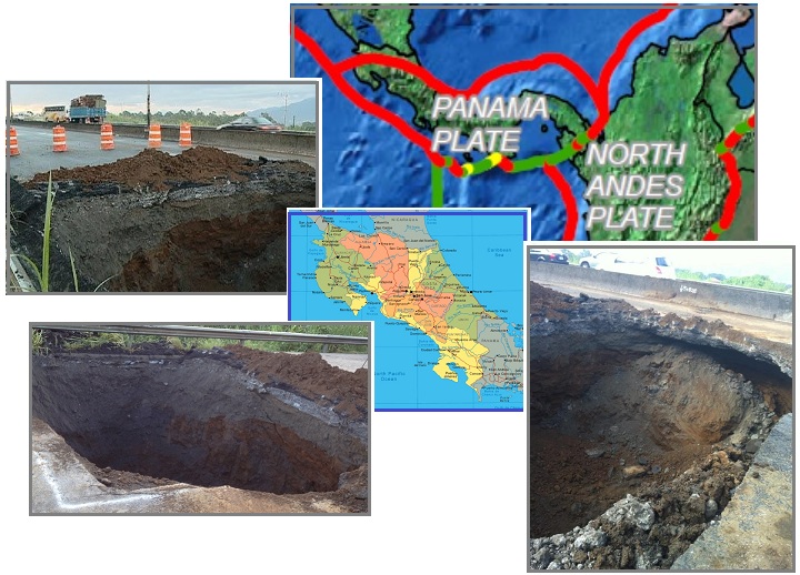
- The Land of Baileys: Costa Rica
Depends on British Ingenuity
June 29, 2012
http://news.co.cr/land-of-baileys-costa-rica-depends-on-british-ingenuity/9296/
- The sizable sinkhole that formed
on the General Canas highway has dominated news headlines
and caused much consternation for many people in Costa
Rica. Critics claim that the sinkhole is just a
super-sized version of the extensive network of potholes
that make up the road in Costa Rica, an occurrence that is
a staple of life in a Third World country where highway
maintenance is routinely ignored. Such criticism ignores
the fact that urban sinkholes that swallow vehicles and
buildings are par for the course in Florida, where in
Marion County 53 new sinkholes opened up after the passage
of a tropical storm.
- Mother of Heucos In Photos
June 28, 2012
http://www.insidecostarica.com/dailynews/2012/june/28/costarica120062808.htm
- Technically it is a sinkhole.
ZetaTalk Prediction
3/22/2010: If
total destruction does not occur during the 7 of 10, it will
during the hour of the pole shift if not before that
time. Panama and Costa Rica will be crushed during the 7
of 10 by the grinding movement of the hump as the great S
American Plate grinds over it. Guatemala, El Salvador,
Nicaragua, and Honduras hardly fare better, though the hump of
S America does not grind over them. Rock strata torn apart is
not local, but has a reach. They will crumple also, but to a
lesser extent during the 7 of 10.
And as a footnote, to show that the crumbling in Costa Rica is
not merely local phenomena but a factor of plate movements, a
huge crevasse opened in central Mexico on July 6, 2012.
Monstrous in size, 60 meters (180 feet) deep, 4 meters (12 feet)
wide and 15 kilometers (45,000 feet) long, this was obviously a
rent in the Earth due to the pressure of the bowing in N
America. Mexico is pulled west, as S America pulls west and
shifts the Caribbean Plate to the west. Since N America is fixed
firmly along its flat top, which runs from Japan to Iceland, it
cannot roll, so must bow, and the pressure struck central Mexico
which pulled in a diagonal manner just as the New Madrid region
will eventually do.
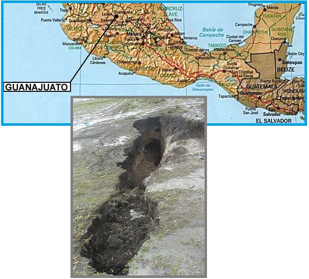
- Crack Appears in Dolores Hidalgo
July 6, 2012
http://www.periodicocorreo.com.mx/comunidades/regionnorte/44908-aparece-grieta
- The crack is 4 meters wide,
approximately 60 meters deep over a length of 15
kilometers. Today communities are cut off for vehicles,
can only be reached on foot or on trails in small cars.
You received this Newsletter because you subscribed to the ZetaTalk
Newsletter service. If undesired, you can quickly Unsubscribe.
|