|
Increased Visibility
The Zetas predicted increased visibility of the Planet X
complex during the 8 of 10 phase, (which is currently
overlapping with the 7 of 10 phase). This became dramatically
obvious during the month of March, 2014 in Alberto’s photos,
inspiring a new Zeta Report video on
YouTube. As noted in Issue
391 of this newsletter, Alberto uses mylar or the insert
from an old floppy disc to filter for
light in the red spectrum, but this increased visibility is now
also apparent naked eye, in the normal light of day. Compare
these photos, taken on March 31, 2014, from Alberto in Italy and
from a FaceBook
entry devoted to capturing chemtrails in Canada. These
are unfiltered photos, showing the presence of the Planet X
complex in normal daylight. Increased visibility indeed!

ZetaTalk Prediction
12/4/2010: This
is information that coincides with the 8 of 10 scenarios, as
yet undescribed, and with the anticipated position of Planet X
vs a vs the Earth for enhanced viewing of Planet X from the
astonished residents of Earth. This time has not yet arrived.
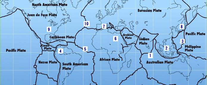
Philippine Plate
Fold
In the 7 of 10 sequence of plate movements, the Zetas described
a folding of the Philippine Plate. First the Sunda Plate is
pushed down under the edge of the Indo-Australian Plate, the
curve formed by Java and Sumatra. Then the Philippine Plate
folds, tilting to push under the Philippine Islands and lifting
on the eastern edge. The 7 of 10 plate movements are interative,
a back and forth bumping with overlap and repetition occuring.
The sinking of the Sunda Plate has
been ongoing for some time, as has evidence of the folding Philippine
Plate which followed after.
ZetaTalk Prediction
10/16/2010: As
the Indo-Australia Plate lifts and slides, this allows the
Pacific plates to shift west, which allows S America to shift
west also. This is greatly increased by the folding of the
Mariana Trench and the Philippine Plate. But it is the
Indo-Australian Plate that gives way to incite change in these
other plates, and this is what is manifesting now to those
closely following the changes.
The 7 of 10 plate movement were slowed by the Council of Worlds,
to allow Obama and other world leaders to break the cover-up
over the presence of Nibiru, aka Planet X, and the pending
passage. Slowed does not mean stopped, however, and these plate
movements continue. The folding of the Philippine Plate
obviously progressed on March 31, 2014 as noted in this Pole
Shift ning blog, when APCN and APCN2 reported two
separate breaks in its network. Note that this network for the
affected regions crossed the borders of the Philippine Plate
repeatedly, most notably where the breaks are reported.
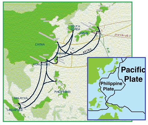
- Damaged Undersea Cables affect
Internet in PH, Asia-Pacific
March 31, 2014
http://www.rappler.com/technology/news/54323-damaged-apcn2-internet-connectivity
- One of the major international
undersea cable systems in the region -- the Asia Pacific
Cable Network (APCN) -- recently suffered two fiber breaks
in the areas between Taiwan-Japan and China-Korea. This
has impacted on telecoms traffic in a large area of the
Asia Pacific region, including the Philippines. As a
result, this may affect your data service. The APCN
consortium that manages the cable system is now
undertaking repairs and expects to finish in
mid-April. The APCN2 is a submarine
telecommunications cable that provides a link for 9
countries: China, Hong Kong, Japan, Malaysia, the
Philippines, Singapore, South Korea, and Taiwan.
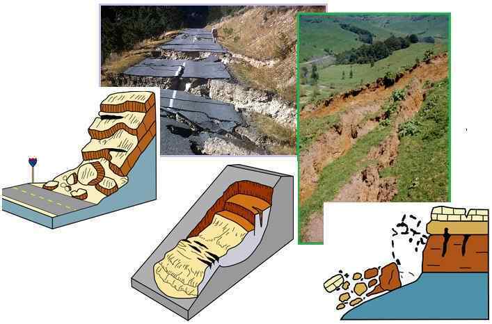
Landslides
Landslides are on the increase, as this Pole
Shift ning blog attests. Recent examples are a horrific
slide in Washington State, where the hillside slid down over a
town below, trapping the residents in a thick slurry of mud. The
hillside was considered unstable, but the residents claimed no
one had pressed that fact on them. Was it a disaster waiting to
happen, or are landslides on the increase?
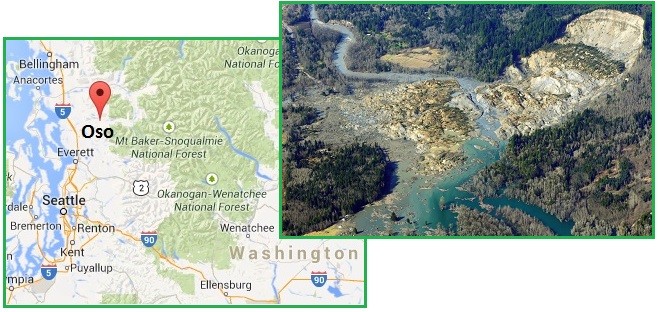
- 176 Reports of People Missing in
Mile-Wide Mudslide
March 24, 2014
http://seattletimes.com/html/localnews/2023215066_mudslidemondayxml.html
- Officials said they have received
176 reports of people missing as rescuers continue to
search the debris from a milewide mudslide in Snohomish
County.
- Fears Rise that More Than 8 Died in
Mudslide
March 8, 2014
http://news.yahoo.com/fears-rise-more-8-died-mudslide-172534848.html
- The 1-square-mile slide swept
through part of a former fishing village about 55 miles
northeast of Seattle. Of the 49 structures in the
neighborhood hit by the slide, authorities believe at
least 25 were occupied full-time. Authorities had to pull
back some crews because of concern about the hillside
moving. Frequent, heavy rainfall and geography make
the area prone to landslides. Less than a decade ago,
another slide hit in the same general area. Geologists and
other experts said the Stillaguamish River likely caused
some erosion in the area that was carved by glaciers.
Landslides are occurring in many places around the world.
Compare the slide above Seattle to this one in Italy. Horrific,
and ongoing. Yet that castle was built atop the hill, in the
past. Per the Zetas, landslides are
on the increase, and the pace will quicken as the Pole Shift
approaches.
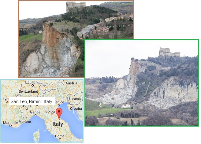
- San Leo, the Landslide Terrorizes:
Evicted Homes, Schools and Barracks
February 28, 2014
http://www.ilrestodelcarlino.it/rimini/provincia/2014/02/28/1032648-san-leo
- Rock collapse in San Leo, Rimini,
Italy. After a site visit and the meeting of the CoC, it
was decided the evacuation of 10 apartments near the
cliff. "Situations are unstable on the wall."
ZetaTalk Comment
3/29/2014: The
causes of landslides are not a mystery to mankind. Layers of
rock and soil such that rain running along a clay or rock
layer can create a slippery surface for the weight of the
layers above it is a common cause. A rock jumble from previous
mountain building, broken or fractured rock easily dislodged.
We have stated that the earthquakes man experiences between
the periodic passages of Planet X can be considered
aftershocks from the last passage, and this is true of
landslides also. Mountain building rumples the landscape, so
the land is not flat but has steep ravines and hill sides.
Older mountain ranges are recognized for their rounded or
smoothed appearance, because of frequent landslides
distributing the rubble.
As we approach another
passage, another Pole Shift, the pace of landslides has picked
up. Why would this be? Plates under pressure will put pressure
on regions that contain rumpled hillsides and deep ravines, as
these give more readily than strictly flat land, thus act as a
weak link. In addition, due to the wobble, the weather has
gotten more extreme, with drought and deluge increasing in
extremes. Dry ground, suddenly flooded with rainwater needing
to seek its level as runoff, will create internal water slides
between the rock and soil layers that constitute the rumpled
hillsides. Is there an early warning system that mankind could
use? The trembles that soil about to slide emits could be
detected, yes. These are not earthquakes, and have their own
frequency.
Mankind has flat land and steep rocky mountain peaks and in
between, rolling hills subject to landslide, as this Idaho
geology site details.
- Landslides
http://www.idahogeology.org/DrawOnePage.asp?PageID=83
- Many landslides are initiated by
triggering factors that increase stress and weaken slope
materials. These triggers include: Heavy rains, rapid
snowmelt, or irrigation that load slopes with water.
Natural erosion or human activities that increase slope
angles or undercut the toes of slopes. Shaking by
earthquakes. Removal of vegetation by wildfire, logging,
agriculture, or overgrazing. Loading of slopes with piles
of rock, ore, or mining waste.
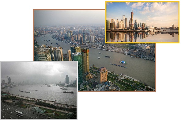
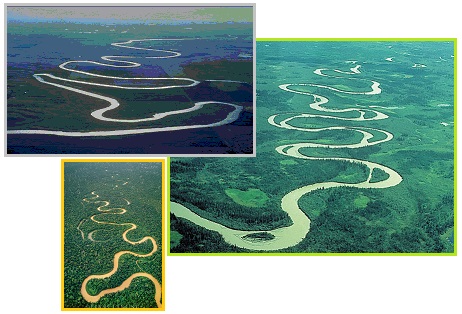
River Danger Zones
If living on hillsides composed of rubble and thus subject to
landslide is dangerous, living along river bottoms will prove
unquestionably disastrous during the Pole Shift. As with coastal
developments, river bottoms allowed for ready transportation by
boat, so settlements naturally sprang up along the banks of the
river. River deltas are also fertile land, due to periodic
flooding depositing soil washed downstream. As cities built up
along the river banks, flooding in the populated cities was
pushed back by levees, as relocating any large investment is
expensive. Thus, the cities grew and grew, in an unsafe area.
Look at this development, hugging the meandering rivers, in
Shanghai, Calgary, London, and Germany.
- Earthquakes, Hurricanes, Cyclones and
Tsunamis: the World's 10 Riskiest Cities
March 25, 2014
http://www.theguardian.com/cities/gallery/2014/mar/25/earthquakes-hurricanes
- With so many cities built on flood
plains and river deltas, flooding is the most common risk
they face. India and China face the most significant
risks; with 11.7 million residents directly threatened,
Shanghai is a particular hot spot for flooding, but other
such risky cities include Bangkok, Mexico City, Baghdad,
Paris and Doha.
- Shanghai Ranks World's 8th Riskiest
City for Natural Disasters
March 26, 2014
http://shanghaiist.com/2014/03/26/well_this_is_just_great_shanghai_ra.php
- Shanghai, unfortunately enough,
happens to be built atop a flood plane.
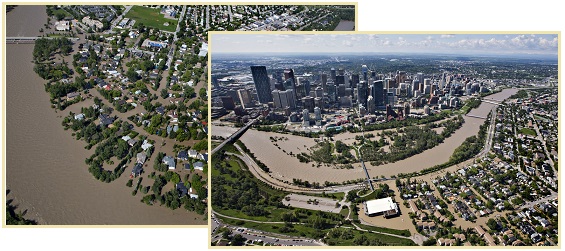
- Epic Flooding in Calgary, By the
Numbers
June 24, 2013
http://www.theatlanticcities.com/neighborhoods/2013/06/epic-flooding-calgary
- Officials and residents are
beginning to clean up Calgary, where the worst flooding in
Alberta's history forced 75,000 people from their homes. A
torrent of water from the Bow and Elbow Rivers, which
nearly overran the city's bridges, receded slowly over the
weekend, leaving streets full of silt, waterlogged cars,
and whole neighborhoods without electricity or working
sewers.
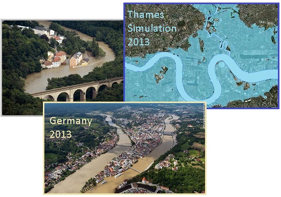
- What London Would Look Like If the
Thames Barrier Failed
December 6, 2013
http://www.theatlanticcities.com/neighborhoods/2013/12/what-london
- Of course, it's just a simulation;
the barrier closed in time for a monster tempest that
forecasters said could deliver the U.K.'s biggest storm
surge in 60 years. The dire prediction that this
gusty weather-socking could be as bad as the
dread North Sea Flood, a killer of roughly 2,500
people in 1953, did not come true, although there is a
report that sea levels were higher this time around.
- Germany Deploys Troops to Assist
Flooded Regions
June 4, 2013
http://www.thetransmittergroup.com/news/politics/Germany-deploys-troops
- Prague was flooded by overflow of
Vltava river and immediate evacuations were ordered in the
region. Reports suggest that this is the worst flooding
experienced by Europe since 2002. Though flood waters in
Danube dipped by 2.5 meters on Tuesday, downstream regions
are expected to see further flooding as water flows down
into the lower tributaries.
The Zetas have repeatedly stated that river bottoms will not
only flood during the hour of the Pole Shift, they will be
scoured. Rushing water will undermine building foundations,
bringing the buildings down into the rushing water. Even well
before the Pole Shift, river drainage is being adversely
affected by heaving ground, so that even the levee systems will
not suffice.
ZetaTalk Warning
10/30/2010: We
have stated that river bottoms are situated along areas of a
plate that are thin, and have thus sunk down, thus becoming a
river bottom.
ZetaTalk Warning
8/13/2011: Attempting
to survive the pole shift along a river or in river bottom
lands is never advised, as the pole shift sloshing can bore up
a river and the torrential rains expected during the hour of
the shift will make them flood beyond all memory in any case.
ZetaTalk Warning
7/29/2013: What
is lost in the reports on horrific and record breaking
flooding is the role that heaving or shifting ground plays in
the inability of water to drain in its accustomed manner. The
N American continent is in a bow, the tip of Mexico pulled
west while the top part of the continent stays in place. The
Aleutian Islands and the tip of Mexico are the ends of the
bow. What happens when the land to the east of the Continental
Divide is stretched in this manner? Grab the edges of a
rumpled blanket and pull it taut and watch the blanket almost
rise from the bed. Rivers drain along the lowlands, and when
these rise as the land is being stretched, the rivers cannot
drain as before.
Examine this aspect of
horrific flooding in various parts of the globe. Uttarakhand
in India is where the flat land of India dives under the
Himalayas. The land is being pushed down, changing the
landscape for water that must drain away from this point.
Water may drain as it did before, but more slowly, may
accumulate at certain points before being released and then
break through an earthen dam to be released in a rush. The
Eurasian Plate is being stretched, sinkholes and twisting
rails a plague from the UK past the Black Sea region and onto
the far East. Thus stretched, river bottom lands in many
places will interfere with drainage, causing flooding.
Levees built by man are arguing with a force of nature, which
wants rivers to meander. Meandering becomes convoluted, and any
analysis over time shows the meander moving and even repeating
the course the river takes. Silt is being deposited over time,
forcing a meander, but allowing for rich river bottom soil to be
available for farming. Crops should be grown in the bottom
lands, but people should live upland in safety.
- Meander
http://en.wikipedia.org/wiki/Meander
- A meander forms when moving water
in a stream erodes the outer banks and widens its valley,
and the inner part of the river has less energy and
deposits silt.
New Video Clips
Two new video clips added on March 30-31, 2014 – March
Madness and MH370
Disaster
 The
Zeta Report 61 – During the month of March, 2014
Alberto's photos of the Planet X complex showed that Planet X
has come closer. Dramatic String of Pearls, slinging Moon
Swirls, and the blast of the tail directly toward Earth. On YouTube. The
Zeta Report 61 – During the month of March, 2014
Alberto's photos of the Planet X complex showed that Planet X
has come closer. Dramatic String of Pearls, slinging Moon
Swirls, and the blast of the tail directly toward Earth. On YouTube.
 The
Zeta Report 62 – What caused the MH370 disaster? All
evidence points to an electromagnetic pulse, as with AF 447, as
the Zetas (right again) stated the day after the plane
disappeared. On YouTube. The
Zeta Report 62 – What caused the MH370 disaster? All
evidence points to an electromagnetic pulse, as with AF 447, as
the Zetas (right again) stated the day after the plane
disappeared. On YouTube.
|