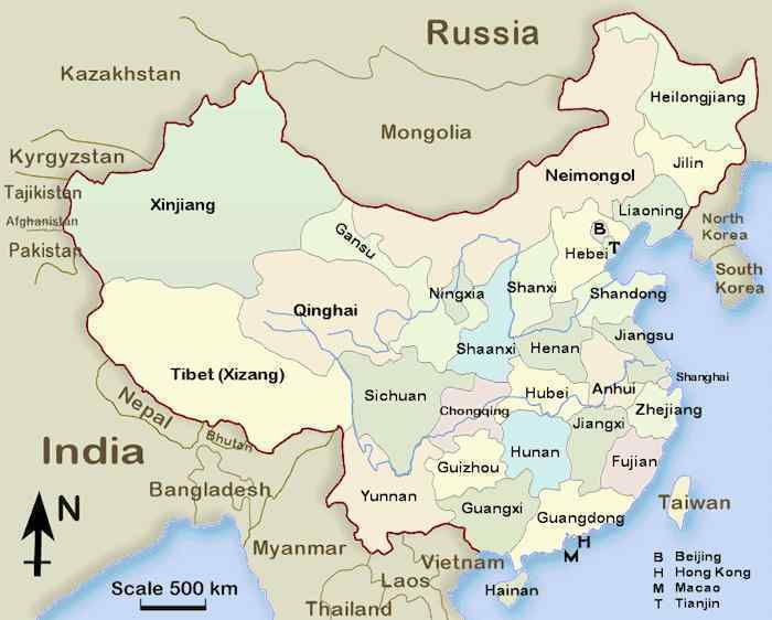
China
Ghost Cities
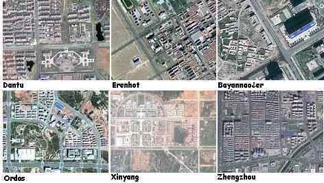
Recently the Daily Mail in the UK published an article about
China's ghost cities, which have been built inland, in often
desolate places, and are vastly unpopulated. The rationale for
these cities is not explained by the state, but Google images
clearly show these are not merely housing complexes - these are
cities!
- The Ghost Towns of China
December 18, 2010
http://www.dailymail.co.uk/news/article-1339536/Ghost-towns-China
- These amazing satellite images
show sprawling cities built in remote parts of China that
have been left completely abandoned, sometimes years after
their construction. Elaborate public buildings and open
spaces are completely unused, with the exception of a few
government vehicles near communist authority offices. Some
estimates put the number of empty homes at as many as 64
million, with up to 20 new cities being built every year
in the country's vast swathes of free land. The
photographs have emerged as a Chinese government think
tank warns that the country's real estate bubble is
getting worse, with property prices in major cities
overvalued by as much as 70 per cent.
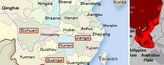
Note that the location of the ghost cities avoids the south
China region warned by the Hangzhou UFO to be subject to a
sinking coastline as part of the 7 of 10 sinking of the plate
tongue holding Indonesia. The coastline warned of a 20 foot drop
in sea level elevation stretched from Hangzhou south along the
coastline to Vietnam.
ZetaTalk Interpretation
7/10/2010: Hangzhou is on the line of
breakage as the tongue of the Eurasian Plate is pulled down
and under the Indo-Australian Plate. This is the line so
active in sinkholes lately, from the point where the Himalayas
are pushing into China across to the coast. The UFO was
reported, sighted, as far south as Guangxi and Guangdong
provinces, which are likewise along the coastlines in the
regions being drawn down as the tongue of the Eurasian Plate
is being bent. These regions, and Hangzhou, are clearly being
warned about tsunami and a suddenly rising sea level as the
plate is bend and pulled down.
The location of the ghost cities also avoid the sinkhole belt,
which stretches from the Himalayas east to the coast, and per
the Zetas represents the swath of land which is bending as the
plate tongue holding Indonesia is pulled down.
The ghost cities are also being built inland, away from what
will be flooded coastlines after the pole shift, and in
provinces far from India, which will be the new S Pole.
ZetaTalk Prediction
5/22/2010: The highlands of the many
provinces that lie between Mongolia and the coast of southern
China will have a climate equivalent to southern Canada today.
This allows Canada to grow grain and house herds of cattle.
The highlands in the provinces, inland from the coast of
southern China, will escape the punishing tidal waves.
ZetaTalk Prediction
5/22/2010: Those above Beijing will find
themselves hosting sputtering politicians, who will attempt to
made demands and expecting subservience. Their climate will
remain similar to today, however, so survivors will have less
adaptation required.
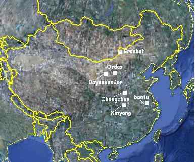
So what is the purpose of these new ghost cities, uninhabited to
date and with NO explanation from the Chinese government as to
their purpose. Per the Zetas, China is taking the ZetaTalk
predictions seriously, and has for the past decades during which
these cities were under construction!
ZetaTalk Explanation
2/12/2011: Cities built within China are
not a corporate effort, they are a state effort, as it is a
communist government. These ghost cities would not be a
mystery if they were corporate developments, as the
corporation would be advertising residences for sale.
Corporate developments also do not include government
buildings, highways, and attention to infrastructure.
Corporate developments build up around existing
infrastructure, building subdivisions or resorts. Given that
this is a state enterprise, why is China doing this?
Note that these ghost cities have been constructed north of
what we might call the sinkhole
belt, a swath of land from the northern
Himalayas east to the coast. The sinkhole belt is caused by
the plate bending as the plate tongue holding Indonesia is
pushed down, sinking. The ghost cities are also inland, not
coastal, and high enough that they would be land even after
the 675 foot rise in sea level we have predicted after the
pole shift. India is expected to be the new S Pole, and thus
provinces in China near India will freeze and struggle, as
northern Canada and Siberia do today. Thus the ghost cities
are to the north of China, in lands that will be temperate. Do
the governments of the world take ZetaTalk seriously? China
certainly has, for the past decade. China is preparing to
relocate its citizens to its new ghost cities from the coast
and from the southern and western provinces near India.
S America Tugging
Per the Zetas the S America roll will be the second 7 of 10
scenario to occur, following closely on the heels of the sinking
of the plate tongue holding Indonesia. Sinking in Indonesia
continues apace, with flooding in new areas and deepening
flooding in those areas affected early in the process, with
flooding "from the sea" and "vicious waves" reported, but the
sinking still has not reached the depth predicted by the Zetas.
Per the Zetas, as explained in Issue
223, plate undulation has set in, causing these delays.
Meanwhile, the rolling of the S American plate continues to tug.
What has occurred in the region since we last reported in Issue 215 that the Panama Canal had been
closed, on December 6, 2010, for the first time in its 125 year
history? Panama is still soggy, and this is not
draining. This per a brave report on the Pole
Shift ning from someone with family in Panama.
My wife is from Panama. I don't
have any physical articles to present as evidence on the
following comments. Panama is experiencing horrible
flooding. The waters are not receding. They are blaming
this on someone not opening the canal doors when it rained
one time, but I don't think that is the cause. I have
heard one theory that it could be the earth's plates that
are rising below the country that will not allow the water
to run off into the rivers and out into the ocean. The
local news doesn't have much coverage of it. For instance
my wife's family lives in Panama City and they only have
potable water 1-2 days out of the week, the rest of the
days they have to go without any water. It has been this
way for over 3 weeks now. This information comes from my
wife's family. I don't know how much of the rest of Panama
is affected by this flooding.
Note that the lack of potable water, reportedly for 3 weeks,
coincides with the reported dates for the collapse of roads in
and around Pamama in the article below. Clearly, sinking in this
region has occurred around January 18, 2011.
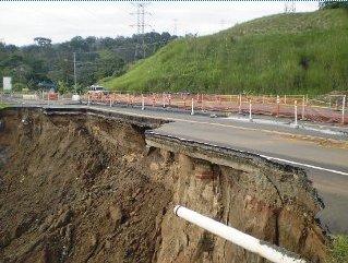
- Fractures Persist on the Transístmic
Road
January 18, 2011
http://mensual.prensa.com/mensual/contenido/2011/01/18/hoy/nacionales/2471546.asp
- Cracks and subsidence, among
other damage, continue to show several sections of track
or Transístmica Roosevelt Boyd, from Colon to Panama and
back, following heavy rains that have lashed the area
since Dec. 8 and hit the road bases. The first collapse
occurred on 15 November, but the rains continued to
undermine the pavement until detach on 13 January. This
has caused along the road that connects the cities of
Panama and there are sections disabled, such as those
listed above, and that drivers have to use a single piece.
Meanwhile, as the hump of the S American Plate continues to
slide over the Caribbean Plate north of Columbia, this does more
than push Panama down. It creates mountain building along the N
Andes Fault Line. A city with almost a million
inhabitants was completely crumbled last December. This city had
been in place since 1857, when it was established in the
Colombian Andes.
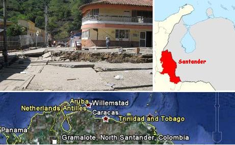
- A Village was Swallowed by the Earth
December 19, 2010
- A Colombian village, Gramalote in
North Santander, is being swallowed by the earth. The town
will disappear in few hours. 90 percent of its population
has been evacuated and rescue teams try to recover
official and historical documents from government
buildings. Gramalote is a municipality of 918,942
inhabitants. It was founded in 1857 on a geological fault
of the Eastern ranges of the Colombian Andes. A hill that
is next to the town, is falling on it.
The crumbling action was described by the Zetas recently, in
graphic terms, as people seemed to be discounting the
seriousness of their prediction for Central America.
ZetaTalk Description
12/11/2010: If total destruction does not
occur during the 7 of 10, it will during the hour of the pole
shift if not before that time. Panama and Costa Rica will be
crushed during the 7 of 10 by the grinding movement of the
hump as the great S American Plate grinds over it. Does this
bring to mind a ride in a car with a bad set of shocks? The
land before you will heave up, up to several hundred feet
high, and tumble toward you. This is an example of what we
mean by "crumbled". Landslides caused by rain and steep
hillsides is not a preview of what to expect! The entire
mountain may sheer off and slide into valleys, crushing not
just a village or road but all civilization for dozens of
miles in either direction, buried under so much rock that
rescue is unthinkable. Valleys will simply fold, the mountain
ranges coming together and squeezing all life out between
them. Guatemala, El Salvador, Nicaragua, and Honduras hardly
fare better, though the hump of S America does not grind over
them. Rock strata torn apart is not local, but has a reach.
They will crumple also, but to a lesser extent during the 7 of
10.
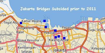
Official
Admissions
Jakarta has been sinking, as noted on September 26, 2010 in Issue 204 of this
newsletter. At that time, their canals had begun to crumble.
News articles to that date indicated that sinking in Jakarta,
due to pulling ground water up and the weight of heavy
buildings, was expected to be a maximum of 10 cm/year, to a
total of 40-60 cm by 2025. This was the projection in 2008 - an
additional 18 inches by 2025. Presumably this was a situation
that had gotten steadily worse as the city grew and the ground
water consumed. A worsening problem. Per a recent article dated
February 9, 2011, the sinking overall, between 1974-2010, was
4.1 meters! And another article, dated February 2, 2011, cites a
danger of a tsunami breaching a sea wall putting parts of
Jakarta under 6 meters of water! Suddenly, since the sinking of
Java has begun, we are talking 4.1 and 6 meter subsidence!
- Indonesia's Thirsty Capital is a
Sinking City
April 15, 2008
http://www.abc.net.au/news/stories/2008/04/15/2217414.htm
- By 2025, estimates from the
Intergovernmental Panel on Climate Change (IPCC) show, sea
levels will have risen by only about five centimetres. But
Mr Brinkman says Jakarta, which spans a flat plain between
mountains and coast, will be between 40 and 60 centimetres
lower than it is now.
-
- Land Subsidence Affecting the Falling
Number of Roads and Bridges in Jakarta
February 9, 2011
http://us.metro.vivanews.com/news/read/203709-dki-diminta-cermati-tujuh-jembatan-anjlok
- Decrease in land surface by 2010
had reached 4.1 meters. Jakarta Konsursium Coastal Defence
Strategy (JCDS) Public Works Department hopes to follow up
the results of the study land subsidence affecting the
falling number of roads and bridges in Jakarta. In the
period 1974-2010 has been a decline in surface soil in the
Jakarta area and 4.1 meters. The decrease in surface soil
in Jakarta, occurred between 5-10 inches each year. In a
preparatory study for manufacturing giant dikes in North
Jakarta, JCDS team found that a number of bridges have
collapsed as part land subsidence, or land subsidence.
Suddenly, Jakarta is worried about the sea breaching its sea
walls, to cause new flooding inland to a depth of 6 meters! This
is in Jakarta general, which is on average 23 feet above sea
level. Have we had sinking, in the Jakarta region such that sea
water can overtop land barriers and inundate low areas to a dept
of 18 feet? Is this in addition to the 23 feet above sea level,
the average for Jakarta? Certainly it is of record that the
island of Java's north coast has recently experienced at least a
20 foot drop.
- Minor Tsunami May Thump Indonesia
Jakarta
February 2, 2011
http://us.en.vivanews.com/news/read/202622-minor-tsunami-may-thump-indonesia-jakarta
- Should the land be flooded by
seawater, the land may subside by up to six meters. Minor
tsunamis may take place. Pasar Ikan floodgate in North
Jakarta has been infiltrated by seawaters by 2 meters in
height.
Meanwhile, sinking continues in Indonesia and the other
countries housed on the plate tongue holding Indonesia. This
past week has been relatively quiescent in that regard as the magma sloshed into the
north Pacific, and was not lifting the eastern end of the
Indo-Australian Plate nor the curve under Sumatra and Java. But
as of February 10, this changed. Another sinking session is
anticipated. But even without the lift to encourage sinking,
sinking has occurred. The dark blue locations are new during the
past week, since February 3, 2011, as indicated in these news articles. Some of the first
locations to sink in late December are being revisited, with
deepening sinking. There are revelations that rivers cannot
drain the waters, flooding is from the sea, choppy waters
capsizing boats, and vicious waves come inland. At no time are
storms reported.
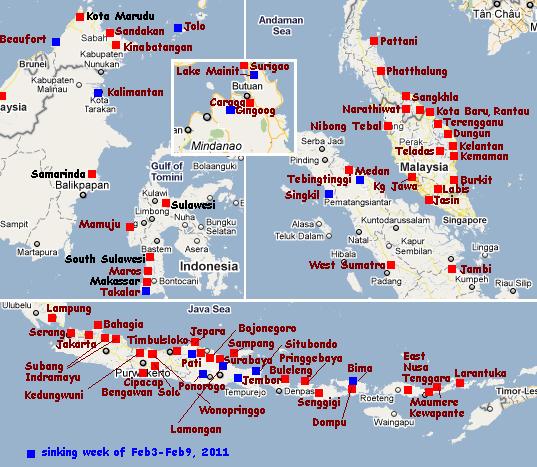
One of the regions to sink recently was Jolo, on the island of
Sulu near northern Borneo, where 10 feet in elevation was
suddenly lost in the middle of the night. This was blamed on a
tornado, though high winds were not in any reports. Very telling
in official admission is the need for a desalination device
so the people will have potable water. The water is from
the sea!
- Definition-de·sali·na·tion (de
sal'? na's?h?n)
- noun
the removal of salt, esp. from sea water to make it
drinkable
also desalinization de·sa'·li·ni·za'·tion (de sa'l? n?
za'-, -sal'?-)
-
- President Aquino leads relief mission
to Sulu
February 11, 2011
http://www.mindanaoexaminer.com/news.php?news_id=20110211054256
- Filipino leader Benigno Aquino
III flew to flood-ravaged southern Philippine town of Jolo
where he distributed relief goods to thousands of victims.
Aquino also said he would ask the Manila Waterworks and
Sewerage System to urge the two water concessionaires of
Metro Manila to help or assist in desalinating the murky
water of the province to ensure that flood victims can
continue enjoying potable water.
India Squeeze
The squeeze is on, with the plate tongue holding Indonesia
collapsing like an
accordion and being pushed under the curve under Sumatra
and Java, causing the countries housed on the plate tongue to sink. The Burma Plate is rising and the
Indo-Australian Plate has tilted so that Pakistan has lost elevation while Sri Lanka is being flooded along its
eastern coastline. The squeeze is on! What does this do to the
continent of India, caught in the midst of this? Central India
has developed tar pits! As noted in the press and on the Pole
Shift ning recently.
There is a district in the State
of Andhra Pradesh, India, called Anantpur where residents
of that district observed the earth developing deep
cracks, almost like the scene in the movie, "Tremors."
From those cracks, smoke is emanating with lava like
material oozing out. In other places, (in the same
district) upon digging the earth, people found hardened,
black stone or earth crust charred to a cinder but firm to
the touch. There is no volcano in and around the area so
it is pretty strange that lava like substance can be
found. A few days later as on Feb/6/2011, in Krishna
district, also in Andhra Pradesh, a man was getting a bore
well dug up and found to his surprise hot water like a
geyser, bubbling on the surface. Geologists dismiss this
in their usual brusque manner as something that happens
when there is an earthquake and that the place experienced
some tremors some time ago, which is not true. Is there a
cover up? Why is the Government not going deep into the
matter? These are some of the questions that crop up in
one's mind when one takes the overall scene of what is
going on in the rest of the world.
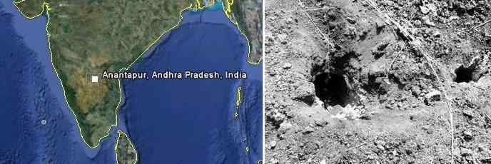
- Black substance spews from earth,
creates panic in Kurnool
February 8, 2011
http://timesofindia.indiatimes.com/india/Black-substance-spews-from-earth
- In a strange phenomenon, a black
chemical substance gushed out from the earth, creating
panic in Maddikera village in Kurnool district. Huge
cavities also formed. The nearby grass caught fire when
the black substance spread like lava from a volcano. A
cement electric pole in the vicinity collapsed.
Per the Zetas, it's just the squeeze.
ZetaTalk Explanation
2/12/2011: Certainly, the rock strata
beneath India is feeling the squeeze, and in such cases the
weak point breaks. Up comes something long buried. Oil comes
in many forms - gaseous, liquid, or tar. In this case, a tar
bed has been breached, and is bubbling to the surface during
the squeeze.
You received this Newsletter because you subscribed to the ZetaTalk
Newsletter service. If undesired, you can quickly Unsubscribe.
|