|
Internet Options
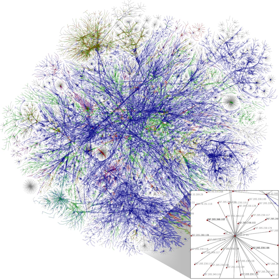
The Zetas have stated that the Internet will not simple be
blocked or taken down in an attempt to restrict the free flow of
information. It is used by commerce and government, worldwide,
and the design of the Internet is such that blocks are simply
bypassed, as this routing path diagram from Wikipedia
demonstrates.
ZetaTalk Insight
12/8/2012: Due
to the nature of the Internet and how it is structured, it is
not possible to shut it down globally unless every country
were to participate willingly in such a shutdown. We have
stated that due to the degree the Internet is used by
government and for commerce, the public is hardly the client
to be most distressed by an Internet shutdown. The Internet,
as designed and functioning worldwide, is like water, flowing
around and through any blockages.
ZetaTalk Comment
2/12/2011: The
Internet was designed to avoid outages by having multiple
routes from one point to another. If one server was down, or
one city were experiencing earthquakes or electrical outages,
traffic would simply be sent on a different route. Thus, if
the undersea cables between Europe and N America were severed
in the Atlantic, traffic would be routed via Asia and across
the Pacific or satellite bounce would be used. This is by
design.
ZetaTalk Comment
11/10/2012: The
Internet functions at the level it does because there are many
routes for a packet to travel, so that if one route fails,
another is tried. Then the packets are pieced together on the
receiving end. The Internet also repeats a send if a
packet is damaged or not received. There is a conversation
going on where the sending site anticipates a return receipt,
and it if does not get it, retries. If there are missing
packets at the receiving end, sometimes the whole conversation
needs to be re-instituted.
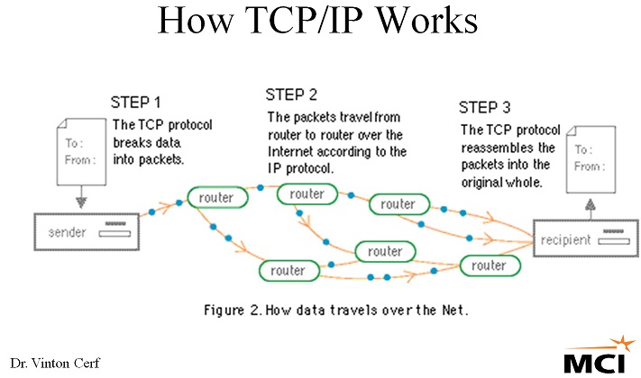
The design of the Internet is based on TCP/IP, with each sender
or receiver having a unique Internet Protocol (IP) address and
any packet of data moved along by the entire Internet toward its
destination. If one route is blocked, another is used, such is
the design.
- TCP/IP Processes, Multiplexing and
Client/Server Application Roles
http://www.tcpipguide.com/free/t_TCPIPProcessesMultiplexing
- IP, TCP and UDP provide the means
of keeping distinct the data from each application. TCP/IP
is designed to allow many different applications to send
and receive data simultaneously using the same Internet
Protocol software on a given device.
- Happy 30th Anniversary, Internet and
TCP/IP!!!
http://www.billslater.com/internet/
- TCP/IP is the protocol that has
run the Internet for 30 years. TCP stands for
Transmission Control Protocol. IP stands for
Internet Protocol. Without an Internet, there would
be no World Wide Web, and there would certainly be no
Facebook, Google, eBay, AMAZON.com, YouTube.com, CNN.com,
etc. In fact, the computer world would probably look
like it did prior to the Internet.
There are two ways to block the information flow. One is to
block at the source, ie take down the website by hacking or
crippling it with a flood of requests via a DDOS attack. The
second it to cut off users, clients in the public, by disrupting
their Internet Service Provider (ISP). Attempts by China or
Saudi Arabia to have a single gateway for the country or
attempts to shut down the Internet in Egypt or Syria during the
Arab Spring failed to
block the Internet as the public simply used dialup connections
via their cell phones, calling outside the region, or other such
bypass techniques.
ZetaTalk Comment
2/12/2011: What
goes into or out from a particular household or business is a
different matter, as this is usually routed through a
particular ISP (Internet Service Provider). Thus, if someone
wanted to restrict you from the Internet, they could either
haul away your PC, or kill your account at your ISP, or close
down your ISP completely.
ZetaTalk Insight
2/22/2014: What
makes the social media aspect of the Internet, in place today,
so threatening to a control oriented establishment is the
ability to send data as well as merely receive. The reason
DDOS attacks are utilized at all against websites and the
servers that host them is due to the inherent nature of the
Internet as constructed years ago. It was designed to overcome
blocks by moving in many different directions. A packet
travels with an IP address, and can take an infinite number of
routes to deliver the packet to do so. It flows like water.
One must eliminate the source, the offending website, to
affect the traffic as once out of the door, there is no
stopping the packet.
The Internet at present is
very competitive, with hundreds of service providers available
to provide Internet access. Savvy users can even purchase a
computer and convert it to a server, becoming one’s own
service provider. The public is not excluded from such
activity. We have often stated that the Internet will not be
shut down, even during rioting that may commence during the 8
of 10 sociological changes, as business and governments use
the Internet intensely. But by getting large portions of the
public to connect to a controlled gateway, such as Google is
offering in cities, one can control those portions of the
public.
So given the importance of the ISP - the phone number one dials
to connect to the Internet such as AOL, the cable provider such
as Charter, the satellite provider such as Hughes – what is to
be made of the sudden rush to provide free access via wifi in
space or balloons in the stratosphere? These technologies will
not truly provide Internet access, as they are more akin to
getting cable TV, where the flow of information is one way, not
interactive. No email. No chats. And a limited selection. This
holds the potential for controlled propaganda.
- Forget the Internet - Soon there will
be the OUTERNET
February 5, 2014
http://www.dailymail.co.uk/sciencetech/article-2552177/Forget-Internet
- An ambitious project known as
Outernet is aiming to launch hundreds of miniature
satellites into low Earth orbit by June 2015. Each
satellite will broadcast the Internet to phones and
computers giving billions of people across the globe free
online access. Citizens of countries like China and North
Korea that have censored online activity could be given
free and unrestricted cyberspace. The group is hoping to
raise tens of millions of dollars in donations to get the
project on the road. Using a technique known as User
Datagram Protocol (UDP) multitasking, which is the sharing
of data between users on a network, Outernet will beam
information to users. Much like how you receive a signal
on your television and flick through channels, Outernet
will broadcast the Internet to you and allow you to flick
through certain websites.
- Coming Soon: Free Internet from Space
February 20, 2014
http://www.nationaljournal.com/tech/coming-soon-free-internet-from-space
- The satellites won't be providing
conventional Internet right away. They'll initially be
used for one-way communication to provide services like
emergency updates, news, crop prices, and educational
programs. Users will help determine what content is
offered. It will be at least five years before Outernet
can offer the more interactive Web as we know it, which
allows users to both access information and upload it.
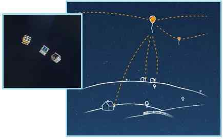
- Balloon-Powered Internet for Everyone
http://www.google.com/loon/
- What is Project Loon? Many
of us think of the Internet as a global community. But
two-thirds of the world’s population does not yet
have Internet access. Project Loon is a network of
balloons traveling on the edge of space, designed to
connect people in rural and remote areas, help fill
coverage gaps, and bring people back online after
disasters. Project Loon balloons float in the
stratosphere, twice as high as airplanes and
the weather. They are carried around the Earth by
winds and they can be steered by rising or descending
to an altitude with winds moving in the desired direction.
People connect to the balloon network using a special
Internet antenna attached to their building. The signal
bounces from balloon to balloon, then to the global
Internet back on Earth.
ZetaTalk Insight
2/22/2014: A
sudden rush to provide an Internet gateway could have many
motives. It could be humanitarian, wanting to provide the
Internet to regions of the world still without access. It
could have a profit motive, even if such access is initially
given away for free. A demand for traditional land-based ISPs
is created, as well as a demand for PCs and phones that can
access the Internet. There are also sinister possibilities, as
where there are many ISPs serving an area it is not possible
to cut off the Internet from the public, but limited gateways
allow this type of control by reducing the access options down
to one.
Outernet, which on the face of
it claims to be providing open access to Communist countries
such as China and N Korea, states that the network of users
would have access only to certain websites, and would not be
interactive for years. Outernet access to the Internet will be
like cable TV, where one has certain channels to choose from
but cannot interact with the TV stations. Nor can the clients
chose what websites they want to browse, beyond clicking
through the selection offered. Project Loon is essentially no
different. What benefit any of this brings to mankind is in
the hands of man at present, as it could move in any
direction, depending upon who is in command.
Atlantic Droop
Both sides of the Atlantic are pulled down during the
continental rip that occurs during each Pole Shift, which the
Zetas have described as a droop on either side of the Atlantic
Rift due to lack of support for land masses on either side of
the rift.
ZetaTalk Prediction
7/15/1995: As
we have stated, the Atlantic will widen and the Pacific will
shorten. Where the Pacific effect will cause sudden and
violent subduction of several plates, which are already
subducting, in the Atlantic the effect will be the opposite. A
gulf will appear, with plates torn apart and the softer magma
under the plates exposed to the cold Atlantic water. Where
this will harden the magma, and establish new plate surface,
there will be less support for the abridging plates, those
that attach however remotely to the shorelines of the
Americas, Europe, and Africa. These non-supported plates will
sink, somewhat, bringing their formerly above-water land
masses down under the water in many places. As an instance,
Europe and in particular the western islands of Britain and
Ireland will find itself more affected than some other parts
of the globe.
This fact has hit the news in the UK recently, as this Pole
Shift ning blog presents. Evidence of an ancient forest
that was pulled under the waves emerge after a storm, and can be
seen at low tide. The Guardian even notes this ancient forest is
estimated to have gone under the waves some 3,100-4,000 years
ago (the passage of Nibiru happens every 3,600 years). The loss
of these lands along the Wales coastline was also captured in a
legend.

- Surreal Seascape Revealed by the
Storms
February 20, 2014
http://www.dailymail.co.uk/news/article-2564285/5-000-year-old-forest-unearthed-storms
- The ancient forest was covered in
peat before eventually being swallowed by the sea.
Scientists knew the forest was there as stumps could
sometimes be seen at low tide. Folklore has it that
Cantre’r Gwaelod, or the Sunken Hundred, a once-fertile
land and township, was lost beneath the waves in a
mythical age. The land is said to have extended 20 miles
west of the present Cardigan Bay, but disaster struck and
Cantre’r Gwaelod was lost to floods when Mererid, the
priestess of a fairy well, apparently neglected her duties
and allowed the well to overflow.
- Prehistoric Forest Arises in Cardigan
Bay after Storms Strip Away Sand
February 20, 2014
http://www.theguardian.com/uk-news/2014/feb/20/prehistoric-forest-borth-cardigan-bay
- Archaeologists also found a timber
walkway nearby, exposed by the storms. It was made from
short lengths of coppiced branches, held in place with
upright posts. It has been dated to between 3,100 and
4,000 years old, built as the local people found ways to
cope with living in an increasingly waterlogged
environment. Human and animal footprints were found
preserved in the hardened top layer of peat, along with
scatterings of burnt stones from ancient hearths.
The issue of the UK being pulled down during each Pole Shift
was last covered in Issue 302 of
this newsletter where the degree of prior sinkage can be
dramatically seen. The Zetas estimate the UK will lose up to 150
feet of elevation in its western lands, due to this draw down
during the Pole Shift.
ZetaTalk Prediction
8/27/2011: We
have predicted the UK in general to anticipate a drop of 75
feet, with Ireland, Scotland and Wales pulled down potentially
by 150 feet, as will the East Coast of the US. The land
essentially flattens between the East Coast of the US and the
islands of the UK, or attempts to do so. This deforming seldom
returns to a pre-deforming state, and after the pole shift
even less support along the rift edges exists, so the land is
also drooping for this reason. Ireland, Scotland, and Wales
face the Atlantic Rift more than the east coast of England,
and thus take the brunt of the droop. One can see from the
underwater shelf that lies to the west of these islands that
this has happened before.
Across the Atlantic in New Hampshire similar sunken forests can
be found. Where the land used to lie, in areas now called the
Continental Shelf, can clearly be seen. Here again the estimate
in years is given variously as beween 3,500-4,000 years or
3,400-3,800 years. We are speaking of the same event on both
sides of the Atlantic.
- Sunken Forests of New Hampshire
http://en.wikipedia.org/wiki/Sunken_Forests_of_New_Hampshire
- Near Odiorne Point State Park in
Rye, this sunken forest is referred to as the "Drowned
Forest". The roots of different coniferous trees
(including white pine and hemlock) are visible at most low
tides. Core samples taken from the roots indicate that the
trees are about 3,500 - 4,000 years old. The Jenness Beach
forest, much larger than Odiorne Point, is rarely sighted
above sea level. The trees, eight to ten feet in
circumference, have been carbon dated from 3,400 to 3,800
years old. Some estimates say that the coastline of New
England used to extend 75 miles (121 km) east of its
current position; a Native American of the era could have
walked from Nantucket to southern Cape Cod without
touching the Atlantic Ocean. Fishermen have hauled up
mastodon and mammoth teeth miles offshore, suggesting that
the forest extended quite far from its western shoreline
boundary.
The spreading Atlantic is also evident in the Caribbean, which
was once so much above the waves that one could walk from Florida
to Venezuela 10 million years ago, as presented in Issue
179 of this newsletter.
Sunken roads near the Bahamas have been in evidence for years, a
favorite of scuba divers, once again dated to approximately
3,500 years ago. Per the Zetas, mankind fears to contemplate
cataclysms in their lifetime, so looks away when such evidence
presents. But it is clear that the Continental Shelf on both
sides of the Atlantic was once land, pulled under during the
periodic passage of Planet X.
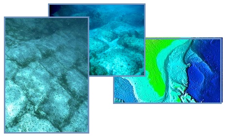
- The Bimini Road: Another Underwater
Mystery
July 24, 2009
http://voices.yahoo.com/the-bimini-road-another-underwater-mystery
- The Bimini Road, also known as the
Bimini Wall, is an underwater rock formation off the coast
of North Bimini Island, in the Bahamas. The Bimini Road is
a fascinating structure and has been a topic of
controversial debate for quite some time now. Is this the
remains of an ancient civilization or is it a natural
formation? The Bimini Road is a 1600 foot long formation
of various shaped stone blocks that appear to have been
cut, and purposely placed in an arrangement that would
serve as a road. The blocks are made up of limestone
composed of shell hash that is referred to as beach rock,
and radio carbon dating tells us that the Bimini Road
roughly is 3500 years old.
ZetaTalk Comment
8/27/2011: It
is known that land off the East Coast of the US, and in the
Caribbean, was once above the waves. The remains of forests
can be seen beneath the waves, roads paved with carefully cut
stones, and the clear outline of where rivers cut through the
previous coastal area. It is clear from the ruins in Central
and S America that civilizations existed in the past, and for
reasons mankind cannot fathom, disappeared. The reason man
struggles with this is that denial is much more comfortable.
To imaging cataclysms that could drop the land beneath
civilizations is too horrific to contemplate.
Second Sun
Planet X as a Second Sun seen at sunrise or sunset is
increasingly evident and captured on video. The Zetas predicted
this increased visibility as part of the 8 of 10 phase, due to
the relative location of Planet X vs a vs the Earth. This was
last addressed in Issue 358 of this
newsletter on August 13, 2013. The Second Sun can be seen in
Germany on November
13, 2013.

In California on February
20, 2014.
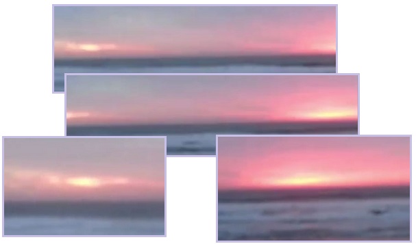
And in a couple videos from the S Pole’s Neumayer Station on January 21,
2014. One of the videos time
stamps the capture.

ZetaTalk Analysis
7/20/2013: As
we predicted would occur during the 8 of 10 phase, visibility
of the Planet X complex has increased. As we have explained,
Planet X and the Earth assume a more side-by-side posture
during the 8 of 10 phase, Planet X moving forward in its path
but the Earth pulling far to the left where it is trapped
within the cup. Visibility increases because the angle of
bounce for sunlight reflected off the vast dust cloud that
shrouds both Planet X and the Moon Swirls is more optimal.
Weather Wobble Shift
The weather wobbles are frequently covered in this newsletter,
as the weather gives evidence of the daily Earth wobble. This
was last covered in Issue 379 of
this newsletter on January 5, 2014 with a graphic showing how
the snow cover in December lines up with the Figure 8 wobble
pattern.
Now, at the close of Winter, Accuweather
has provided another image showing the variation this past
Winter from average temps during 1981-2010. Note that the wobble
has shifted west, to some degree, because Planet X has shifted
to the right relative to the Earth, which has shifted to the
left in her attempts to evade the hosing of magnetic particles
coming from the magnetic N Pole of Planet X. This shift can
clearly be seen in the temperature variation map!

- Rough Winter to Lag Into March for
Midwest, East
February 25, 2014
http://www.accuweather.com/en/weather-news/rough-winter-to-lag-into-march
- Steering winds high in the
atmosphere, known as the jet stream, have been in a very
high amplitude configuration for months. Early in the
winter, the pattern developed big southward dip in much of
eastern North America and a northward bulge in western
North America. Since Dec. 1, 2013, Minneapolis has
averaged 8 degrees below normal with Chicago at 7 degrees
below normal and Detroit 6.5 degrees colder than average.
ZetaTalk Comment
12/21/2013: Weather
extremes are due to the Earth wobble, as where there are
places of extreme or unusual cold, there are likewise
simultaneously places of extreme or unusual heat! While the
east coast of the US is experiencing extreme December cold,
Alaska is almost in a thaw. And where the Middle East is
shocked to be under snow, much of Europe seems to be
experiencing an early Spring. The wobble is more violent,
swings farther North and South, and parts of the Earth
affected by this are getting, thus, more or less sunlight.
|